


Tonight’s Forecast:
A disturbance to our west that will bring snow to the mountains tonight will keep our skies partly to mostly cloudy. In spite of the clouds, precipitation is not expected east of the mountains from this storm. Overnight lows tonight won't be as cold as last night as the coldest air should stay in the mountains and mountain valleys.
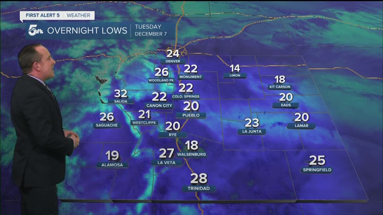
COLORADO SPRINGS: Low: 24; High: 48. Breezy and warmer on Tuesday, with decreasing clouds by the afternoon and evening and near average highs for the Pikes Peak Region.
PUEBLO: Low: 21; High: 53. A nice warming trend for our Tuesday as highs rebound into the lower 50s.
CANON CITY: Low: 30; High: 52. Skies will turn partly cloudy to mostly sunny by the middle of the day as temperatures warm quite a bit from what we saw Monday.
WOODLAND PARK: Low: 26; High: 43. Mostly cloudy skies early will give way to a mostly sunny and breezy afternoon across Teller County. Afternoon gusts of 20-30 mph will be possible.
TRI-LAKES: Low: 10s/20s; High: 40s. Snow will fall across the mountains through midday Tuesday, but for northern El Paso County, our forecast will be dry and breezy, with near seasonal temperatures expected.
PLAINS: Low: 20s; High: 40s/50s. Lighter winds and more sunshine for our Tuesday across the Plains, and much more comfortable temperatures expected for afternoon highs.
WALSENBURG/TRINIDAD: Low: 20s/30s; High: 40s/50s. We'll see a nice warming trend on Tuesday thanks to a healthy dose of afternoon sunshine and breezy downslope winds.
MOUNTAINS: Low: 20s; High: 30s/40s. Snow from our current storm will largely miss our southeastern mountains as the snow looks to stay closer to the Continental Divide. If you're traveling into Monarch Pass or the central mountains, you can expect wintry driving conditions and possible delays because of the snow.
Extended Outlook:
A dry, downslope wind pattern will bring warmer than average highs to the I-25 corridor and Plains from Wednesday into Thursday. Mid-week highs will warm into the 50s and 60s, and spotty high fire danger may develop in some of our more wind prone areas. For the mountains, a second storm will bring the potential for more robust snow totals starting Wednesday night, with the potential for snow through the start of the weekend. For the I-25 corridor, light accumulations may occur from Friday afternoon into late Friday night.
KOAA News5 on your time, streaming on your Roku, FireTV, AppleTV and AndroidTV.
