


Tonight's Forecast:
Other than a few spotty showers and thunderstorms over the mountains this evening, we're looking at a dry and warm night across Southern Colorado. After midnight, cooler air will settle into the forecast as overnight lows outside of the mountains drop down to the 50s and 60s.
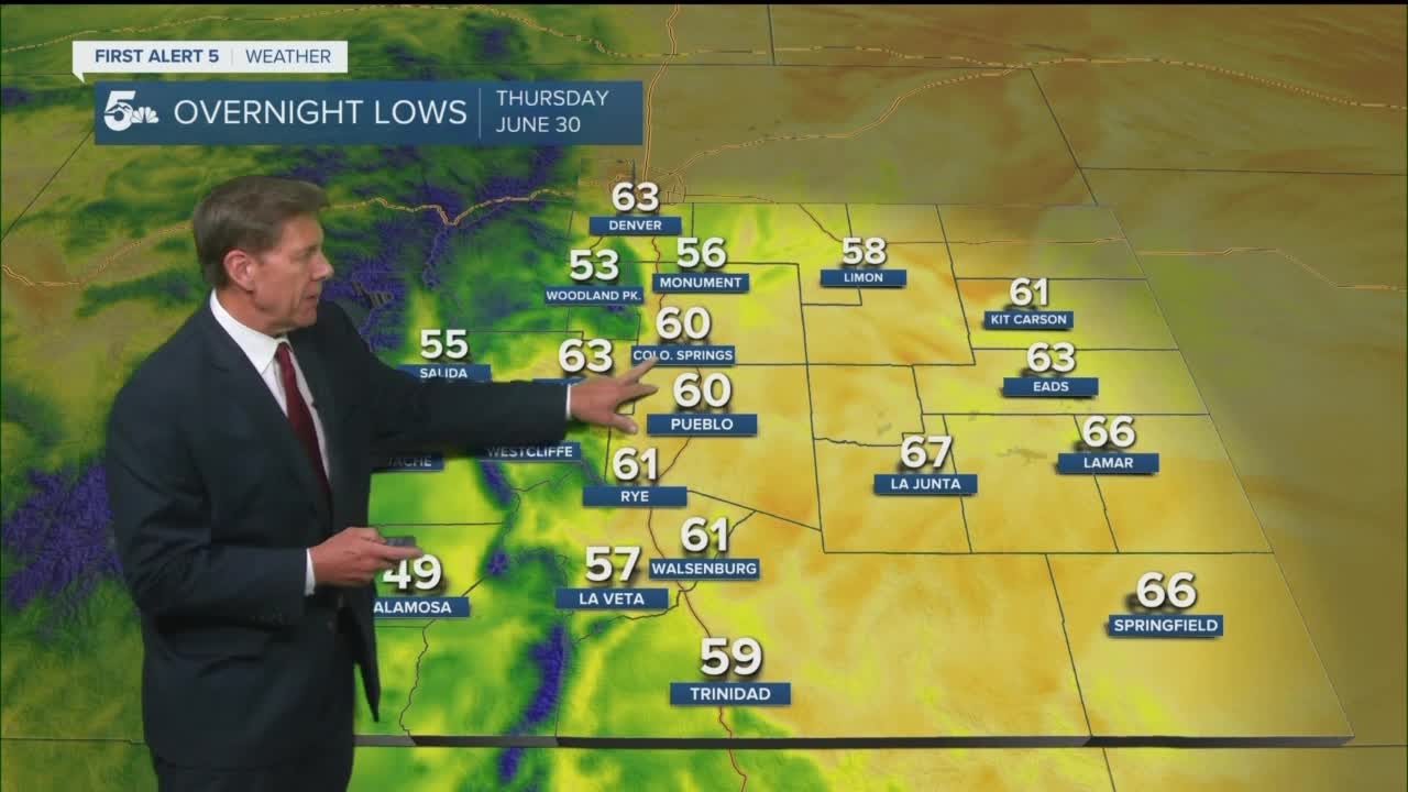
Colorado Springs forecast: Low: 60; High: 85; A cold front will drop in around the lunch hour, helping to provide a modest amount of cooling to our highs on Thursday. Moisture will also increase behind the front, with a solid chance of afternoon and evening thunderstorms for the Pikes Peak Region.
Pueblo forecast: Low: 60; High: 93; Slightly cooler Thursday, with morning sunshine giving way to scattered late afternoon and evening thunderstorms.
Canon City forecast: Low: 63; High: 91; Mostly sunny in the morning, with the mercury expected to rise quickly during the day. Skies will turn mostly cloudy by the afternoon hours, with showers and thunderstorms building across the Arkansas River Valley.
Woodland Park forecast: Low: 53; High: 76; Partly cloudy with a slight chance of thunderstorms by late morning. Skies will turn stormy by the afternoon as showers and thunderstorms are expected to move across Teller County.
Tri-Lakes forecast: Low: 50s/60s; High: 70s/80s; Partly sunny skies early will give way to building showers and thunderstorms Thursday afternoon as the monsoon looks to become a much more active player late this week.
Plains forecast: Low: 60s; High: 90s; The heat will remain in place for one more day on the Plains ahead of a cooler day on Friday. Mountain showers and thunderstorms will have a much better chance to reach the Plains tomorrow, with afternoon and evening thunderstorms possible.
Walsenburg and Trinidad forecast: Low: 50s/60s; High: 80s/90s; Storm potential will start to increase on Thursday as the monsoon returns to Colorado. For the southern I-25 corridor, spotty to scattered thunderstorms will be possible by late afternoon and evening.
Mountains forecast: Low: 50s; High: 60s/70s; More widespread thunderstorms will return to the mountains on Thursday as the monsoon drifts back into Colorado, and promises an active start to the holiday weekend.
Extended outlook forecast:
With the monsoon flow becoming more pronounced late this week and weekend over Southern Colorado, storms will become more widespread from Friday to Saturday. Along with the threat for afternoon and evening thunderstorms, we'll also be watching closely the potential for burn scar flooding, as well as urban flooding. Moisture is expected to thin out some from Sunday to Monday, with storm chances on the more isolated side. As rain chances lower, temperatures will rise back to seasonal levels by the Fourth of July.
Speaking of the 4th...isolated thunderstorms during the afternoon should give way to calmer conditions by Monday evening.
____
Curious about the First Alert 5 Weather Storm Impact Scale? Check out our cheatsheet explainer.
Watch KOAA News5 on your time, anytime with our free streaming app available for your Roku, FireTV, AppleTV and Android TV. Just search KOAA News5, download and start watching.
