


Tonight's Forecast:
Throw a few logs on the fire place if you've got one and hunker down for a cold night here in Southern Colorado. Before the cold settles in, some additional snow showers will continue, with the snow likely wrapping up by around 8 pm for the I-25 corridor, but closer to midnight for the eastern Plains.
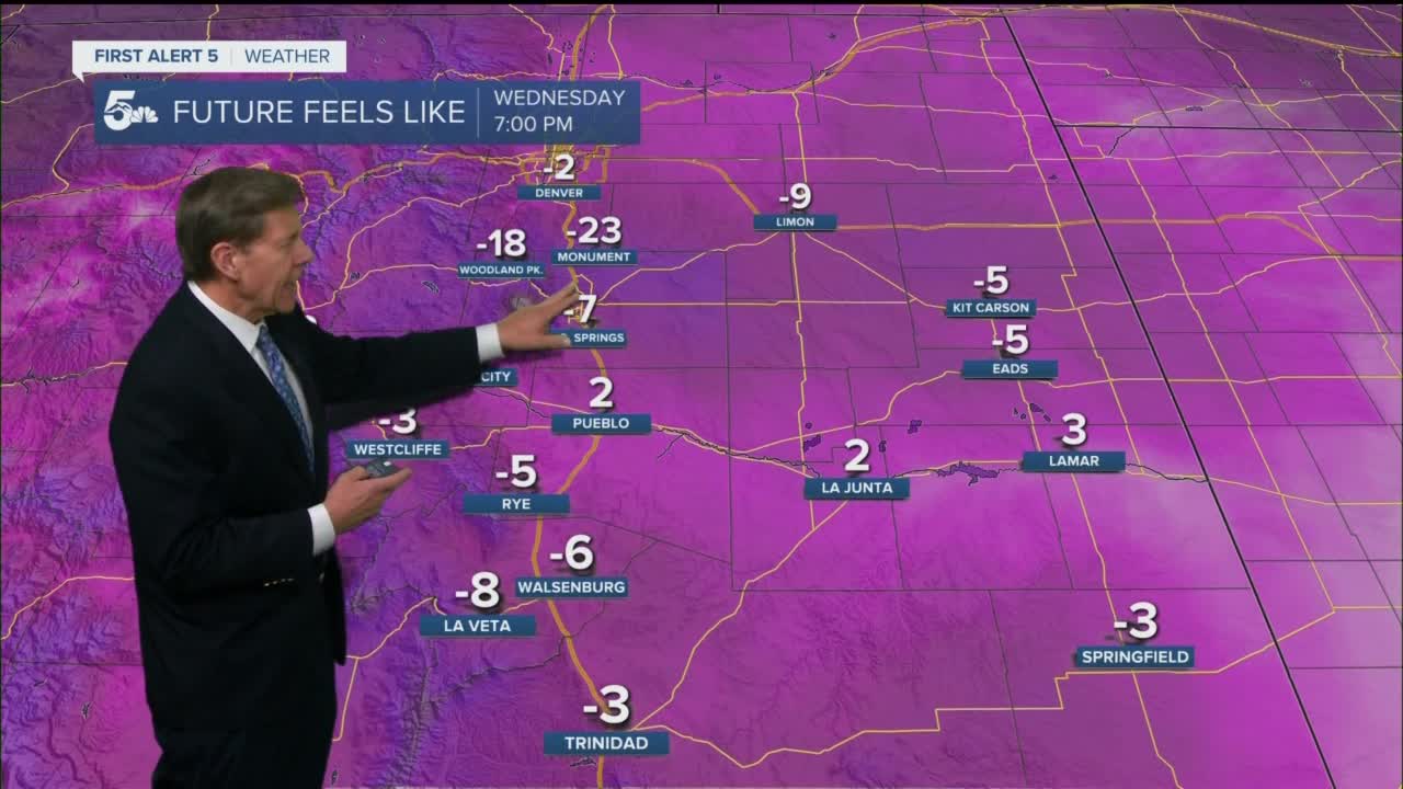
At this time, a Winter Storm Warning remains in effect until 11 pm for parts of Southern Colorado, with a Wind Chill Advisory in effect until 8 am Thursday for northern parts of El Paso County. In these areas, dangerous wind chill temperatures as low as -15 to -25 degrees could bring frostbite to exposed skin in as little as 30 minutes.

Colorado Springs forecast: Low: 3; High: 28; Wind chill temperatures down in the negatives Thursday morning will moderate by the afternoon as well as the actual air temperature as sunshine returns to the Pikes Peak Region. With the snow gone, we'll see a return to upper 20s by the afternoon.
Pueblo forecast: Low: 3; High: 31; A partly cloudy and cold start to our Thursday will give way to lower 30s and sunshine by the afternoon, which should allow for some snowmelt to begin.
Canon City forecast: Low: 4; High: 31; Single digit lows and negative morning wind chill temperatures will give way to a high on Thursday near the freezing mark in Canon City, which should help to melt away some of today's snowfall.
Woodland Park forecast: Low: -5; High: 23; Layer up if you have to be outside early in Teller county, because you'll be feeling the big chill until the sun can come out and warm us up. By the afternoon, daytime highs will top out in the lower 20s.
Tri-Lakes forecast: Low: -0s/0s; High: 20s; Brutally cold morning temperatures and wind chill values will give way to middle and upper 20s by the afternoon as sunshine returns in the wake of today's storm.
Plains forecast: Low: 0s/10s; High: 20s/30s; With the snow coming to an end late tonight, we'll see a return to sunshine on Thursday for the Plains of Colorado, along with a very cold day.
Walsenburg and Trinidad forecast: Low: -0s/0s; High: 20s; A no-fun dose of winter chill behind today's storm will bring single digits and negative lows to the southern I-25 corridor overnight tonight and Thursday morning. Thankfully by the afternoon, sunshine will allow our highs to top out in the 20s.
Mountains forecast: Low: -0s/0s; High: 10s/20s; After getting hammered over the past 24 hours, the snow will come to an end in the mountains late tonight, leaving us very cold, but at least dry and sunny by Thursday.
Extended outlook forecast:
Sunshine and near average highs on Friday will give way to a wonderful weekend. Highs in the Plains will return to the 50s, with Sunday looking like the warmest day. The weekend warm-up will continue on Monday before our next storm arrives on Tuesday, bringing the potential for a return to more wintry weather for Southern Colorado.
____
Curious about the First Alert 5 Weather Storm Impact Scale? Check out our cheatsheet explainer.
Watch KOAA News5 on your time, anytime with our free streaming app available for your Roku, FireTV, AppleTV and Android TV. Just search KOAA News5, download and start watching.
