


This blog is not being updated in real-time. Check back in at 6 a.m. Tuesday for the latest.
Snow ends by 11 pm-midnight for the Pikes Peak region (Teller and El Paso Counties) and ends by 2 am for the entire region. Temperatures will drop to the teens and single digits overnight. Roads will still be icy or snowy in the morning on Tuesday.

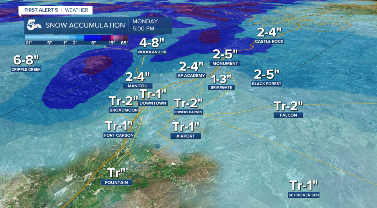
Additional snowfall between 6 pm and overnight:

MONDAY 10:00 P.M. Update:
Southbound I-25 is closed at exit 64, eight miles south of Colorado City. Northbound I-25 between Graneros Road and Highway 165 in Colorado City remains closed for a crash.
MONDAY 6:00 P.M. Update:
Eastbound Highway 50 is closed at mile Fourmile Lane in Cañon City for a crash. Highway 160 is closed in both directions from Carson Avenue in Fort Garland to Beaver Creek Road, which is located near Walsenburg for safety concerns.
MONDAY 4:00 P.M. Update:
I-25 between Graneros Road and Highway 165 in Colorado City is closed in both directions for a crash. Expect delays. According to the Colorado Department of Transportation (CDOT) there is a 10 minute delay northbound and a 14 minute delay southbound.
MONDAY 1:00 P. M. Update:
ROAD IMPACTS
- Per CDOT: Northbound I-25 closed at Milepost 180 at Plum Creek Parkway just south of Castle Rock due to multiple weather-related crashes. One lane reopened.
- Per Colorado State Patrol (CSP): Crash along Southbound I-25 blocking traffic at Baptist Road.
- Per CSPD: Crash at Hancock and Milton Proby Pkwy., unknown blockage.
- Per CSPD: Crash Mesa Rd. and Uintah, unknown blockage.
- Per CSPD: Multiple crashes Tutt Blvd. and Tutt Center Pt., vehicles sliding on hill. Avoid the area.
- Per CSPD: Crash at Rockrimmon Boulevard and I-25 unknown blockage.
- Per CSPD: Crash Broadmoor Valley Rd. and Star Ranch Rd., unknown blockage.
- Per CSPD: Crash SB Southgate north of Lake, blocking traffic.
- Per CSPD: crash Motor City Dr. and 8th St., unknown blockage.
- Per CSPD: Crash Bijou and I-25, blocking ramp to NB I-25.
- Per CSPD: Vehicle vs. transformer box New Life Dr. and Voyager, unknown blockage.
- Per CSPD: Vehicle vs. transformer box WB N. Carefree and Peterson, blocking the right lane.
- Per CSPD, Crash Murray and S. Carefree, blocking traffic.
- Per CSPD: Crash along North Bound I-25 south of Woodmen. An emergency vehicle is blocking the center lane.
- Per CSPD: Crash at Woodmen and Duryea, unknown blockage at this time.
Measuring Snow Correctly:
When measuring snow it's best to do this on a flat, grassy surface. Pavement tends to be warmer than those grassy surfaces, and the snow will compact more. It gives meteorologists a better idea of how much snowfall we got when it's on a grassy surface.

Snow Totals Forecast:
The higher totals will be for the southern portion of I-25, but there will be periods of limited visibility. Use caution while driving in these conditions.

Track this storm through the morning, including snow totals and updated forecasts, on the First Alert 5 Weather stream, which can be viewed on the KOAA News5 app for your Roku, FireTV, AppleTV or AndroidTV.
Resources:
- Get your latest First Alert 5 Weather Forecast
- Find the current school closing and delay list
- Keep track of flight delays at Denver International Airport or the Colorado Springs Airport
- Watch KOAA News5 LIVE newscasts and updated content throughout the day in your browser, the News5 App, or your favorite streaming device.
- Download the free News5 App for your iOS or Android device to get the latest headlines and news across Colorado.
- Download the free First Alert 5 Weather App for your iOS or Android device to get the latest headlines and news across Colorado.
- You can find us on social media with KOAA on Youtube, Facebook, Instagram, and Twitter
