


Today’s Forecast:
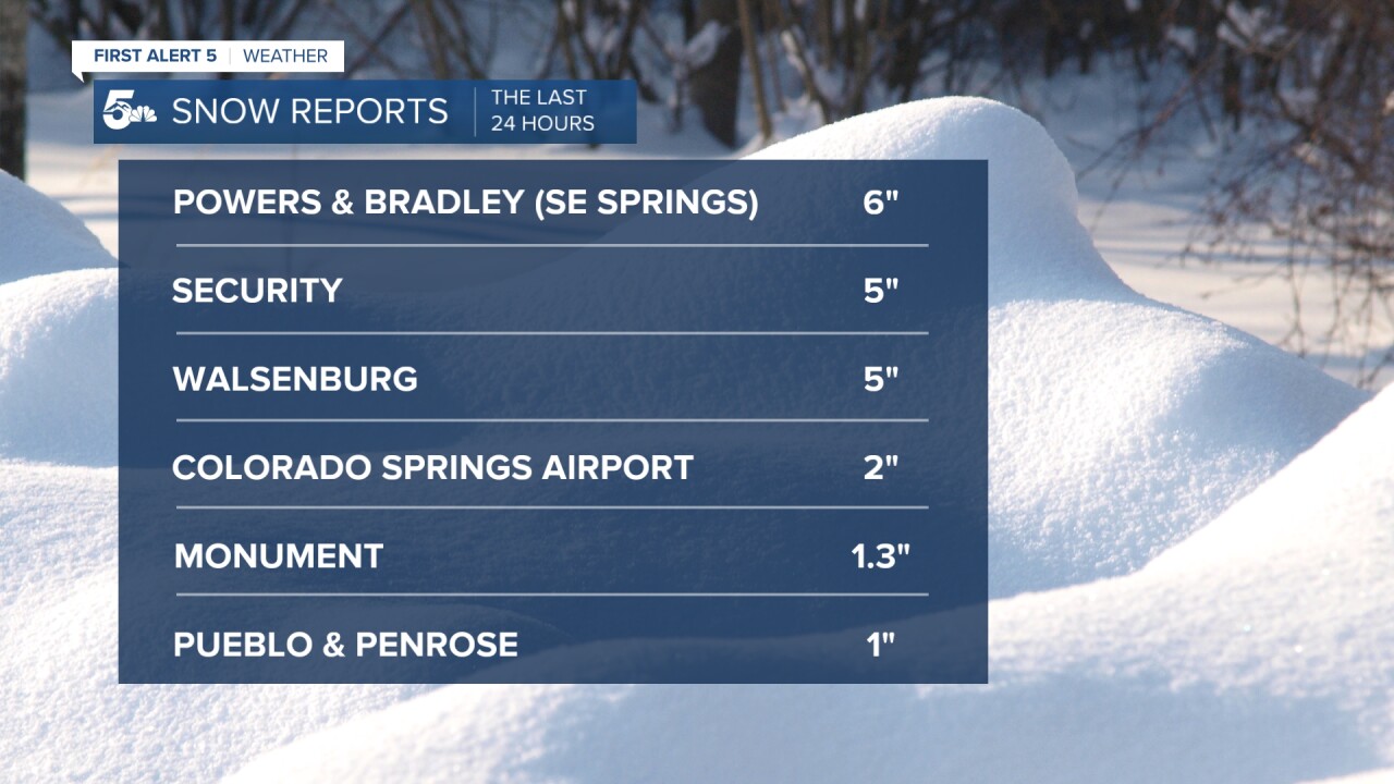
It's a tale of two cities this morning, with parts of Southern Colorado waking up to several inches of snow whereas other areas didn't see any snow at all. The worst hit areas were in southeastern Colorado Springs, with several reports of 5-6" of snow coming into our newsroom.
The storm has cleared out this morning, but has left us foggy. Whether it be fog or icy roads, make sure to give yourself a little extra time today getting to work. Sunshine this afternoon will feel nice as highs look to top out in the 40s and 50s.
Colorado Springs forecast: High: 45; Low: 24. A cold, foggy start to our Wednesday will give way to a seasonably cool afternoon as today's high looks to warm into the middle 40s. Sunshine this afternoon should help to melt away last night's snow that impacted central and southern parts of the city.
Pueblo forecast: High: 49; Low: 20. Areas of fog, along with snow covered roads this morning may slow down your morning commute by a few minutes. Afternoon sunshine will feel nice, with our high today topping out near 50 degrees.
Canon City forecast: High: 52; Low: 30. Sunshine on Wednesday will allow for a seasonably cool afternoon, with our high today topping out in the lower 50s.
Woodland Park forecast: High: 44; Low: 22. It's cold out there this morning, with single digits in Teller County. Sunshine this afternoon will melt away yesterday's snowfall while bumping temperatures into the middle 40s.
Tri-Lakes forecast: High: 30s/40s; Low: 20s. A cold and foggy Wednesday morning will give way to a bright and chilly afternoon, with today's highs warming into the upper 30s and 40s.
Plains forecast: High: 40s/50s; Low: 20s/30s. Areas of fog this morning along with icy streets will make for a wintry start to our Wednesday on the Plains. Sunshine by the afternoon will melt away the snow and warm us into the 40s and 50s.
Walsenburg and Trinidad forecast: High: 40s/50s; Low: 20s. Cold out there this morning, with snow on the ground in parts of Huerfano County. Sunshine throughout the day will feel pretty good as today's highs warm into the 40s and 50s.
Mountains forecast: High: 30s; Low: 0s/10s. Wednesday will be a beautiful but chilly day in the high country as sunshine returns to our forecast, and winds remain on the light to moderate side.
Extended outlook forecast:
After a pretty active first half of the week, we're expecting our weather to "chill out" on Thursday. Sunshine, light breezes and much warmer highs can be expected tomorrow as high look to rebound into the 60s on the Plains.
Highs will climb further into the 60s and 70s on Friday and Saturday, with stronger winds expected region-wide. Along with the high winds will come an increased threat of high fire danger as we head towards the upcoming weekend. Moisture in the extended looks fairly limited, with our next chance for rain or snow late on Sunday.
____
Curious about the First Alert 5 Weather Storm Impact Scale? Check out our cheatsheet explainer.
Watch KOAA News5 on your time, anytime with our free streaming app available for your Roku, FireTV, AppleTV and Android TV. Just search KOAA News5, download and start watching.
