


Today’s Forecast:
Wicked winds may have woken you up in the middle of the night, and so far this morning, the wind remains strong and gusty across most of Colorado. A High Wind Warning will remain in effect until noon for the southern mountains, the foothills, Teller County, western El Paso County and eastern Fremont County. Gusts in some areas are expected to top 80 mph through the lunch hour, with the strongest gusts on the eastern mountain slopes.
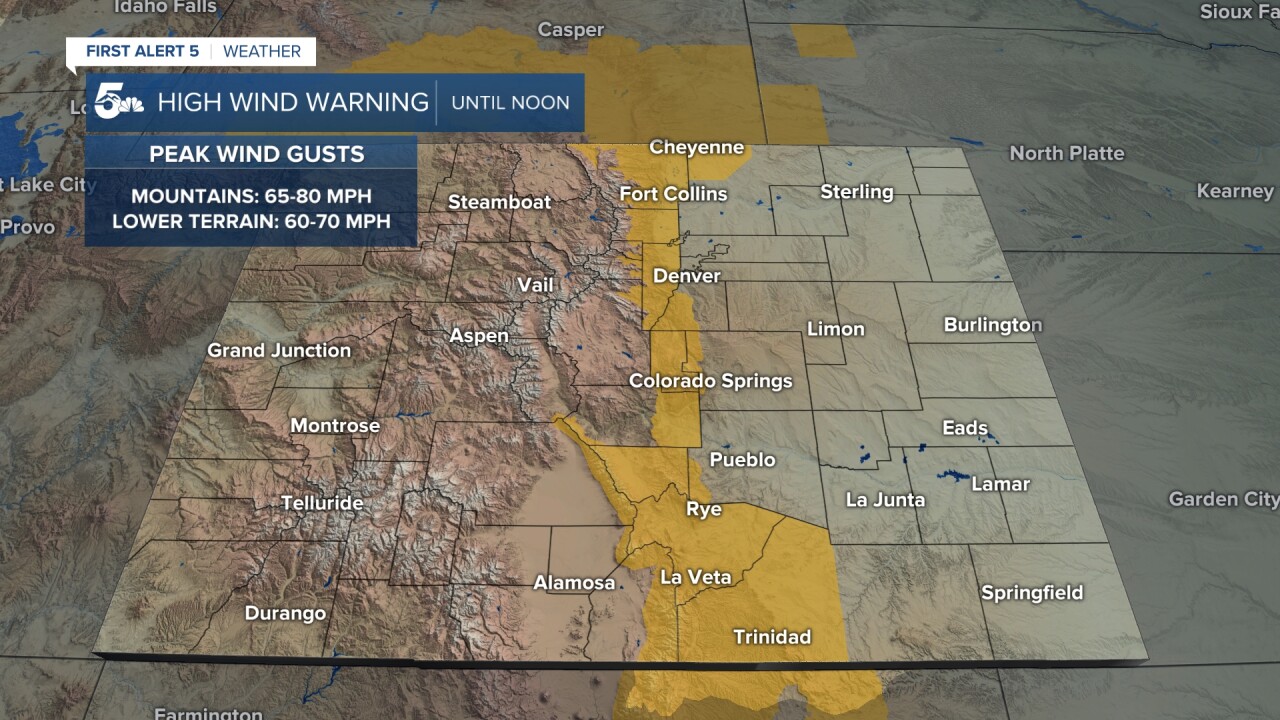
On top of the wind today, Red Flag Warnings will remain in effect from 10 am until 10 pm for the San Luis Valley and southeastern Plains. For the mountains, heavy snow is expected to impact travel most of today.
Colorado Springs forecast: High: 62; Low: 37. Western parts of El Paso County have been added to today's High Wind Warning. Gusts in the foothills could top 95 mph. Gusts along and east of I-25 today will range between 40-60 mph. Travel on N-S oriented roadways could be impacted by wind, flying debris and blowing dust.
Pueblo forecast: High: 70; Low: 37. Wicked winds will continue to scream across Pueblo County through at least the lunch hour, with peak gusts up around 60 mph. Even though skies will be mostly sunny today, areas of blowing dust and sand may impact visibility during periods of stronger wind.
Canon City forecast: High: 64; Low: 41. A High Wind Warning is in effect until noon today in eastern Fremont County, with gusts in some areas up over 60 mph.
Woodland Park forecast: High: 50; Low: 30. A cooler and very windy start to the week in Teller County, with a High Wind Warning in effect until at least noon. Some gusts in Teller county today could top 80 mph.
Tri-Lakes forecast: High: 50s; Low: 30s. A chilly and windy start to the week for the Palmer Divide and Tri-Lakes region. Gusts today will range between 40-60 mph, with some weakening of the wind this afternoon and evening.
Plains forecast: High: 60s/70s; Low: 30s/40s. With gusts today around 40-60 mph, areas of blowing dust and sand can be expected on the Plains. Even though we're not under a High Wind Warning today on the Plains, a Red Flag Warning will remain in effect in some areas from 10 am until 10 pm.
Walsenburg and Trinidad forecast: High: 60s; Low: 20s. A High Wind Warning will remain in effect until noon today for the southern I-25 corridor, where peak gusts of 60-80 mph will be possible. The strongest wind gusts will be west of I-25 into the wind prone foothill areas.
Mountains forecast: High: 40s; Low: 20s. For the mountains on Monday, a High Wind Warning will remain in effect until noon. Gusts to 90 mph will be possible in some areas. For our state's northern and central ranges, a combination of snow and very strong wind may lead to difficult driving conditions at times today.
Extended outlook forecast:
A strong area of low pressure will move to our north on Tuesday, but will keep the wind howling across the state. Gusts on Tuesday will be around 40-50 mph in Colorado Springs and Pueblo, with our high tomorrow warming into the 60s, 70s and very low 80s on the Plains.
Highs will be cooler late this week, with a breezy high of 60 degrees in Colorado Springs on Wednesday. Moisture is expected to increase region-wide late this week, with a better chance for afternoon showers and thunderstorms both Thursday and Friday.
____
Curious about the First Alert 5 Weather Storm Impact Scale? Check out our cheatsheet explainer.
Watch KOAA News5 on your time, anytime with our free streaming app available for your Roku, FireTV, AppleTV and Android TV. Just search KOAA News5, download and start watching.
