


Tonight's Forecast:
As a trough of low pressure moves into western parts of the state tonight, rain showers will push into these areas. Along the I-25 corridor and the Plains, it will be windy at times this evening. These gusty winds will keep us much more mild tonight compared to the previous few nights.
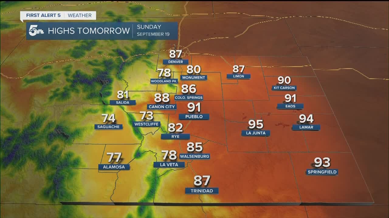
COLORADO SPRINGS: Low: 57; High: 86. Very warm and windy on Sunday as fire danger increases across the Pikes Peak Region due to the forecast and drying fuels.
PUEBLO: Low: 58; High: 91. About as a hot as Saturday, but even windier during the afternoon hours. Peak wind gusts of 20-30 mph will be possible.
CANON CITY: Low: 57; High: 88. A mild morning will give way to a warm and breezy final Sunday of summer.
WOODLAND PARK: Low: 48; High: 78. With fall just days away, the final Sunday of summer will be a warm and breezy one for Teller County, with generally dry skies expected.
TRI-LAKES: Low: 50s; High: 70s/80s. Warm and breezy, with rain not expected for the Palmer Divide through Sunday evening.
PLAINS: Low: 50s/60s; High: 90s. Late-summer heat returns to the Plains once again on Sunday. Gusty winds will accompany the heat, with near critical fire weather conditions possible in some areas.
WALSENBURG/TRINIDAD: Low: 50s; High: 80s. Gusty west/southwest winds will bring a dry heat to the forecast again on Sunday as highs climb into the middle and upper 80s.
MOUNTAINS: Low: 30s/40s; High: 60s. Periods of rain will be possible across the mountains this evening, with an isolated chance lingering into Sunday ahead of some cooler changes (and snow) early next week.
Extended Outlook:
A powerful Monday morning cold front will bring us a windy and cooler start to the week. The strongest gusts are expected Monday morning when the front passes through. Locally, only iolated showers will be possible from this storm as most of the moisture looks to stay well to our north. Snow showers will be possible Sunday night and Monday across our state's central and northern mountains, with some light accumulation also possible on Pikes Peak. Cooler, fall-like temperatures will continue through Tuesday before we warm things up late next week.
KOAA News5 on your time, streaming on your Roku, FireTV, AppleTV and AndroidTV.
News5 App | First Alert 5 Weather App | Youtube | Facebook | Instagram | Twitter
