


Tonight’s Forecast:
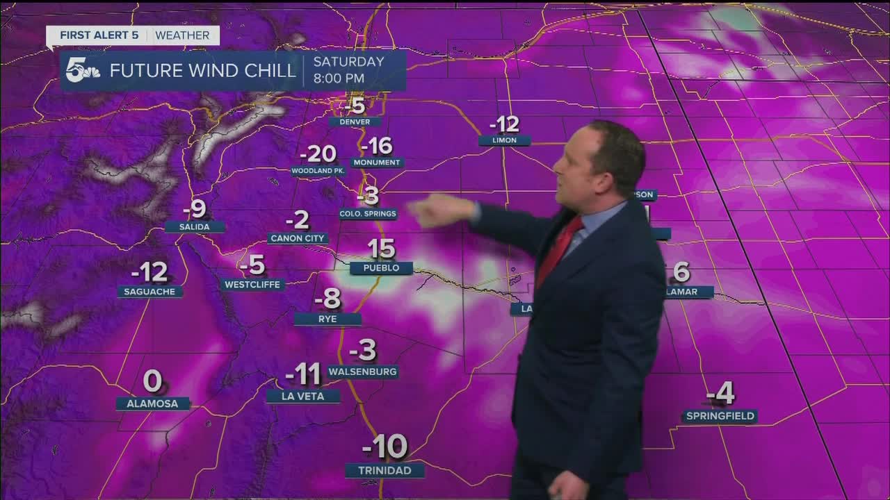
Clearing skies will lead to some frigid overnight temperatures. By Sunday morning, we'll see negative lows and single digit temperatures across Southern Colorado. Wind chill values during the overnight hours will be as cold as -10 to -25 degrees, and the worst of it will be across the eastern Plains and the San Luis Valley. These areas will be under Wind Chill Advisories and Wind Chill Warnings through 10 am Sunday. If you have to be outside during this time, make sure to cover all exposed skin to avoid the potential threat of frostbite. This can develop within 15-30 minutes with wind chill values this low.
COLORADO SPRINGS: Low: 0; High: 42. Brutally cold morning temperatures and dangerous below zero wind chill values will quickly give way to a near average afternoon temperature wise as highs rebound into the lower 40s.
PUEBLO: Low: -4; High: 43. Below zero morning temperatures and even colder wind chill values will give way to a sunny and pleasant afternoon as temperatures climb into the lower to middle 40s.
CANON CITY: Low: 2; High: 45. The cold will be the big story Sunday morning as temperatures start out in the single digits. Thanks to abundant afternoon sunshine, daytime highs will top out in the middle 40s.
WOODLAND PARK: Low: -5; High: 36. A brutal cold morning will give way to just barely above freezing highs in Teller County that top out in the middle 30s.
TRI-LAKES: Low: -0s; High: 30s/40s. Below freezing temperatures and dangerous wind chills will continue into Sunday morning before warming into the upper 30s and lower 40s for daytime highs.
PLAINS: Low: -0s; High: 30s/40s. Tonight we'll see the coldest air of the season, with some areas nearing negative 10 degrees. Because of the cold, Wind Chill Advisories will remain in effect from 11 pm to 10 am Sunday.
WALSENBURG/TRINIDAD: Low: -0s/0s; High: 30s/40s. Cold and breezy tonight, with dangerous wind chill temperatures expected to continue for most of the night. Sunday's weather will be bright and breezy, with highs in the 30s and 40s.
MOUNTAINS: Low: -0s; High: 20s/30s. Drying out, but a very cold night for the mountains and mountain valleys, with dangerous wind chill values for all areas. Sunday afternoon will be sunny, cold and gusty as afternoon wind gusts could top 35 mph.
Extended Outlook:
High pressure, our fair weather maker, will deliver a much welcomed warming trend for the first part of the work week. By Tuesday, a digging trough of low pressure will spread stronger gusts into Southern Colorado, with possible high fire danger. Our forecast will remain windy through Wednesday before a cold front brings some moisture and the potential for light snow showers Wednesday night into Thursday morning. Accumulations look light this far out. Following the cold front will come another dose of cold weather on Thursday.
KOAA News5 on your time, streaming on your Roku, FireTV, AppleTV and AndroidTV.
