

COLORADO (KOAA) — Colorado's snowpack has not kept pace with even the worst SNOWTEL-era snowpack curve in the last several weeks, and conditions are likely to worsen significantly in the next two weeks.

Over the past two weeks, snowpack has decreased from 63% of average to 61% of average. Keep in mind: if we don't get enough new snow, our snowpack percentages go down. That is to say: 5/10 (50%), is a higher percentage than 5/12 (41.6%). If the average goes up, and snowpack itself does not, the snowpack percentage goes down. That's what that number means. But the more alarming development is that the snowpack itself — not just the percentage — is now physically shrinking.
According to data from the USDA, the snow water equivalent, which measures the amount of water contained in the snowpack, dropped from 8.6 inches on Tuesday to 8.4* inches today. That kind of decline is highly unusual for early March and raises the possibility that snowpack may have already peaked for the season. This is not certain as April patterns aren't in focus yet - but the long range trends aren't good, either.

Basin-by-basin maps show little change from last week, with some basins up a percent or two and others in the southwestern tier down a percent or two. Most of Colorado's water supply — and much of the West's — comes from winter snowpack.

The outlook is expected to deteriorate further. An intense ridge of high pressure will build across the southwestern United States next week, bringing widespread, record-breaking heat to Colorado in the middle to end of next week. The combination of the higher sun angle typical of early March (providing more energy to melt snow) and that intense heat is likely to rapidly accelerate snowmelt.
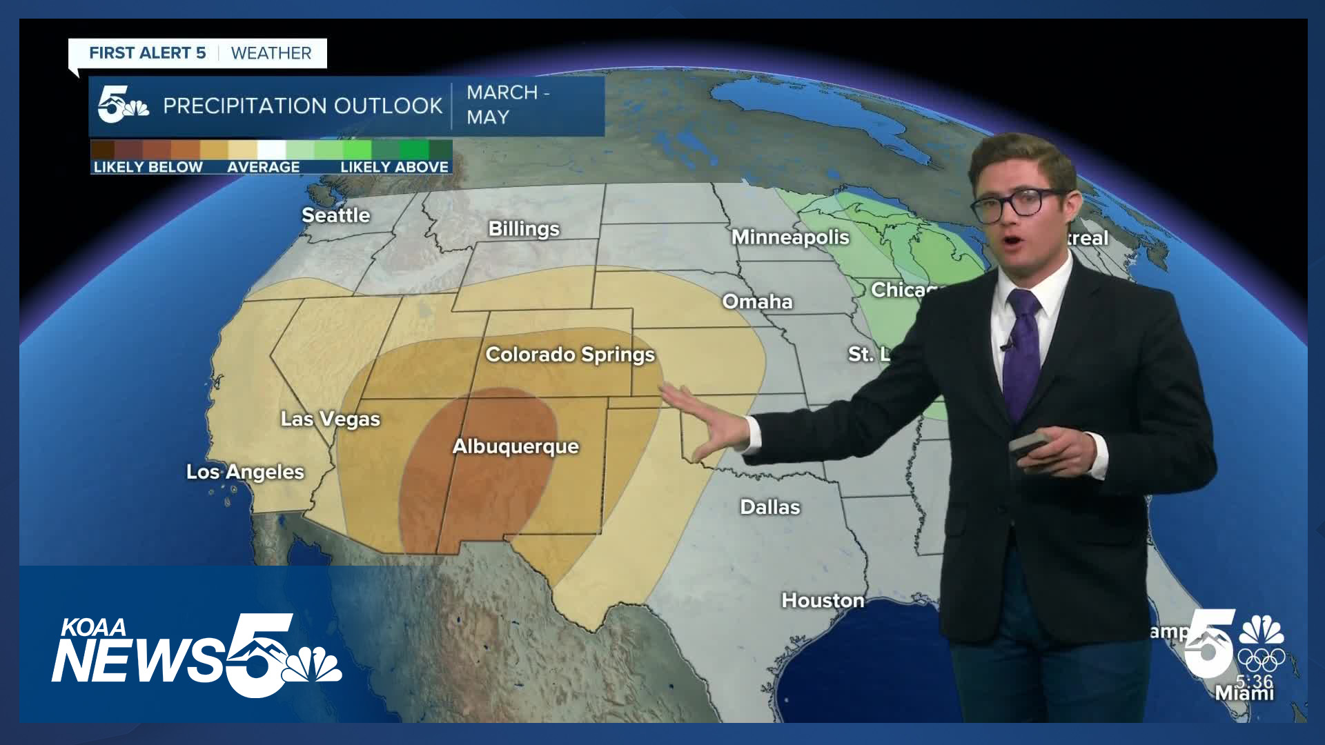
Looking further ahead, the Climate Prediction Center is forecasting above-average temperatures across Colorado through May, along with below-average precipitation through the same period. Long range models, such as the ECMWF Weeklies, and global weather patterns, back this possibility up. While conditions in April remain uncertain, the overall trend is not encouraging.
This is a serious situation, and the outlook doesn't leave much room for optimism.
*An earlier USDA report from 12:00 AM on 3/11/26 reported 8.3" SWE, which has been revised at the time of publication to 8.4".
____
Have a question or story idea you would like the First Alert 5 Weather team to consider? Email: weather@koaa.com
Watch KOAA News5 on your time, anytime with our free streaming app available for your Roku, FireTV, AppleTV and Android TV. Just search KOAA News5, download and start watching.
