

Today’s Forecast:
A big warm up is slated for our Wednesday as this week's persistent layer of stratus clouds will finally burn off today. If you've been craving some vitamin D in your life in Colorado Springs or Pueblo, we should see clearer skies return this morning. With both sunshine and a building ridge of high pressure in our forecast today, highs will be around 15-20 degrees warmer than yesterday. Highs will warm into the 60s and 70s in the mountain valleys, with 70s and 80s today on the Plains.
Colorado Springs forecast: High: 76; Low: 48. As we approach sunrise, this morning's blanket of low clouds and fog will continue to erode away from south to north across the Pikes Peak Region. Highs today will be as much as 15-20 degrees warmer than Tuesday.
Pueblo forecast: High: 81; Low: 49. Wednesday's forecast will feature much warmer highs and a triumphant return to sunshine. Highs this afternoon will top out in the lower 80s.
Canon City forecast: High: 79; Low: 52. Sunny skies and warm highs can be expected on Wednesday, with temperatures this afternoon around 6-10 degrees above average.
Woodland Park forecast: High: 68; Low: 40. A building ridge of high pressure will bring us a bright and mild afternoon, with a near perfect high today of around 68 degrees.
Tri-Lakes forecast: High: 70s; Low: 40s/50s. Morning clouds and fog will give way to an abundance of sunshine today. This will allow for a pretty significant boost in temperatures as highs this afternoon top out in the 70s.
Plains forecast: High: 70s/80s; Low: 50s. Patchy morning fog on the Plains will give way to a bright, breezy and warm afternoon. Southerly wind gusts on the High Plains today will be around 25-35 mph.
Walsenburg and Trinidad forecast: High: 70s; Low: 50s. We'll see a bright, breezy and warm day on Wednesday, with highs this afternoon climbing into the 70s.
Mountains forecast: High: 60s; Low: 30s/40s. It will be mostly sunny and breezy in the mountains on Wednesday, with only a slight chance for showers in the Sangre de Cristos this afternoon. Peak gusts to 35 mph.
Extended outlook forecast:
Thursday will begin with sunshine, and end with increasing clouds. As high pressure peaks over Colorado, highs will be even warmer than today, topping out in the 80s on the Plains.
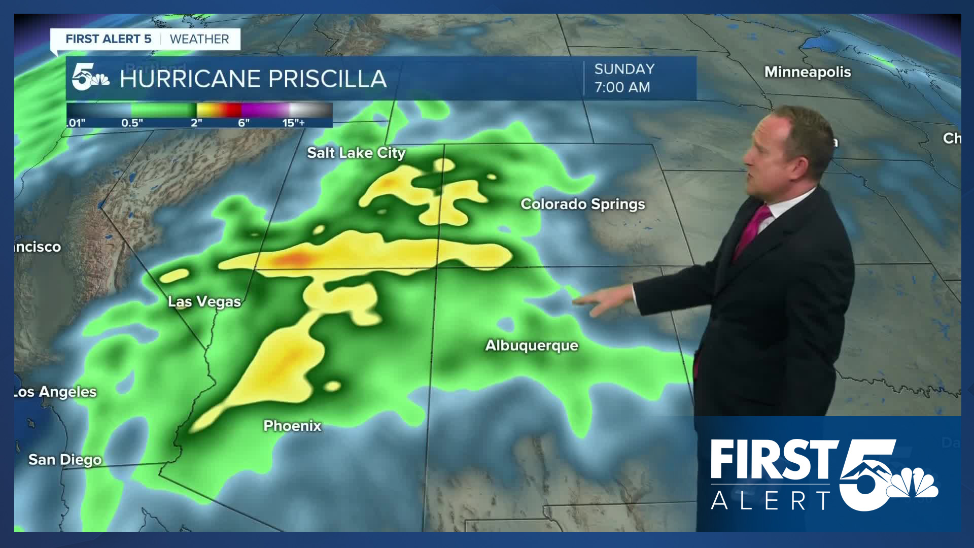
Highs will cool back down to the middle 70s on Friday in Colorado Springs due to increasing clouds and moisture coming into the state from the remnants of Hurricane Priscilla. This will bring the potential for heavy rain and high elevation snow to western Colorado this weekend, and a small chance of a shower or two Friday afternoon or evening in the Pikes Peak Region. Highs will remain in the 70s this weekend, with afternoon wind gusts up around 25 mph. While rain will continue in the mountains, showers will remain unlikely for most of Southern Colorado this weekend.
____
Curious about the First Alert 5 Weather Storm Impact Scale? Check out our cheatsheet explainer.
Watch KOAA News5 on your time, anytime with our free streaming app available for your Roku, FireTV, AppleTV and Android TV. Just search KOAA News5, download and start watching.
