

Today’s Forecast:
Temperatures on Monday will be pretty similar to the past few days, with a mix of 80s and 90s on the Plains, and 70s for the higher elevations. Temperatures today will be around 5 degrees above average in most areas.
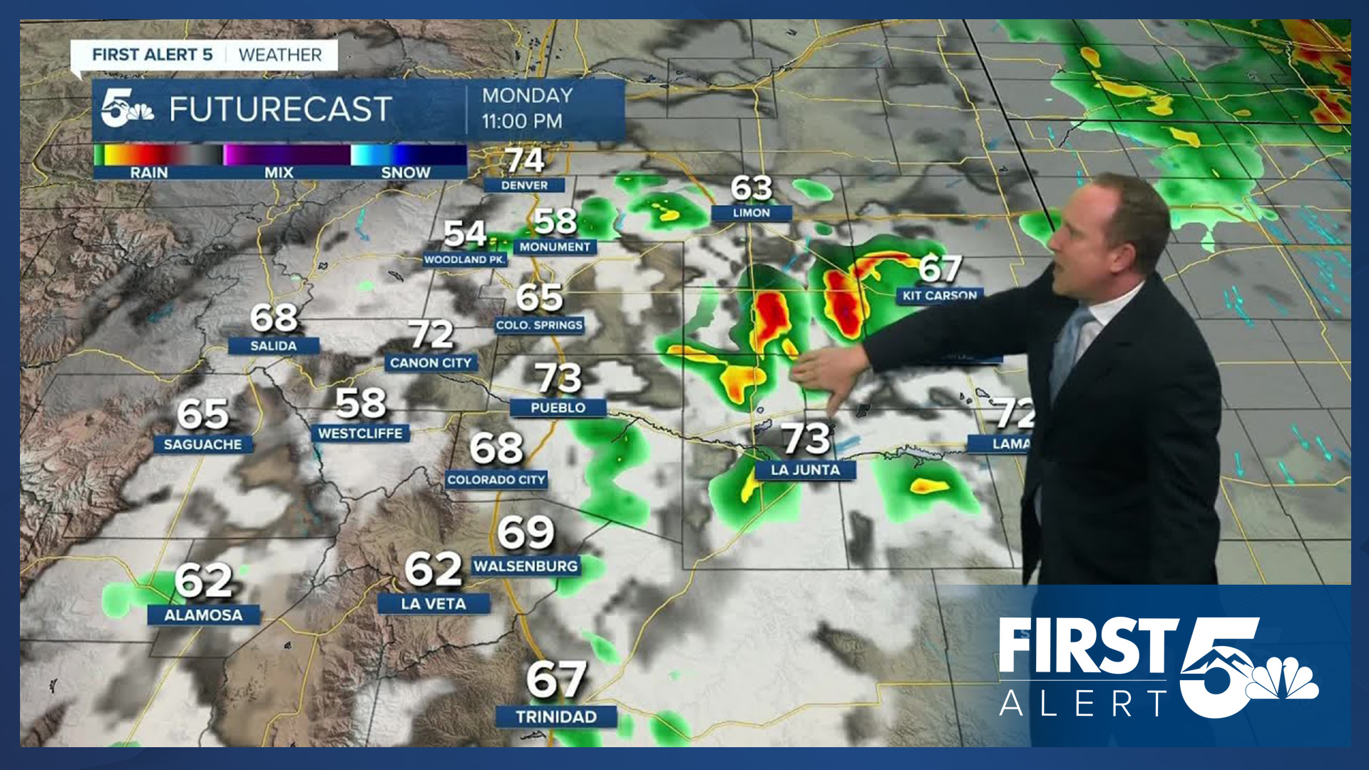
Moisture will be slightly more abundant today, which gives way to the potential for spotty to scattered thunderstorms this afternoon and evening. Storms look to fire off as early as the lunch hour in the mountains and Pikes Peak Region. Storms should mostly remain sub-severe for areas close to I-25 today, with lower end severe threats possible on the eastern Plains. Thunderstorms today will be capable of strong and gusty winds, plus hail up to 1" in diameter.
Colorado Springs forecast: High: 88; Low: 59. Little change temperature wise on Monday as highs climb back into the upper 80s in Colorado Springs. Storm chances however will be higher than yesterday, with scattered thunderstorms developing after the lunch hour in the Pikes Peak Region.
Pueblo forecast: High: 96; Low: 61. Hot and slightly more humid today as we're looking at the possibility of at least a few thunderstorms in Pueblo County. Rain chances in town will be around 25% this afternoon and evening.
Canon City forecast: High: 94; Low: 62. The work week will begin will above average highs and muggy conditions. The higher dew points will help to aid in the potential for scattered showers and thunderstorms this afternoon.
Woodland Park forecast: High: 78; Low: 48. It will be a warm and more humid start to the week for Teller County, where thunderstorms could form even before the lunch hour today. Lightning and gusty winds will be our main storm threats.
Tri-Lakes forecast: High: 80s; Low: 50s. This week will begin with warmer than average highs and a pretty good shot at some rain this afternoon and evening. Storms today will be capable of strong wind, small hail and frequent lightning.
Plains forecast: High: 90s; Low: 60s. Two rounds of rain will be possible today on the Plains. One towards the late afternoon and early evening, with a second rain of rain later tonight into Tuesday morning. Storms east of I-25 will also have the potential to bring severe threats to some areas, including 60 mph wind gusts and 1" hail.
Walsenburg and Trinidad forecast: High: 80s/90s; Low: 50s/60s. Dry skies this morning will give way to low end rain chances this afternoon. Storms here are not expected to reach severe criteria.
Mountains forecast: High: 70s; Low: 40s. Thanks to an influx of monsoonal moisture, the mountains will be ground zero for thunderstorm development on Monday. Storms will bring the potential for heavy rain and gusty winds, along with small hail and frequent lighting. Outside plans today could be impacted as early as 11 am to noon.
Extended outlook forecast:
Recycled moisture on Tuesday may allow for a rogue shower or thunderstorm in the Pikes Peak Region, with our high in Colorado Springs warming back into the upper 80s. Similar temperatures will continue on Wednesday ahead of one day with our high hitting the lower 90s on Thursday. Highs in Pueblo and Canon City this week will warm into the 90s, and may even hit 100 degrees in some areas on Thursday.
An incoming cold front on Friday will drop highs back down to the upper 80s in Colorado Springs as building thunderstorm chances return by Friday afternoon. More numerous storms are expected this weekend across the state as the monsoon flow becomes quite active. Highs will be cooler, topping out in the upper 70s to lower 80s this weekend in Colorado Springs.
____
Curious about the First Alert 5 Weather Storm Impact Scale? Check out our cheatsheet explainer.
Watch KOAA News5 on your time, anytime with our free streaming app available for your Roku, FireTV, AppleTV and Android TV. Just search KOAA News5, download and start watching.
