

Today’s Forecast:
Your Friday will be a comfortable outdoor activity type of day in Southern Colorado. Although feels like temperatures early today are in the low teens along much of I-25, and negative in the mountain valleys - high pressure to the west of the Centennial State leads to another day with northwesterly flow. Winds today will be light, but that wind direction is downslope, which will help temperatures rise to the 40s and low 50s this afternoon. You'll see some passing mid-level clouds in the mid-morning period.
Otherwise, it's a comfortable end to the week but change will arrive tonight. A backdoor cold front - arriving from the northeast - will push into the state this afternoon. This may result in flurries over the eastern plains, and eventually pockets of fog in the Pikes Peak Region tonight. Some portions on the High Plains could see freezing fog.
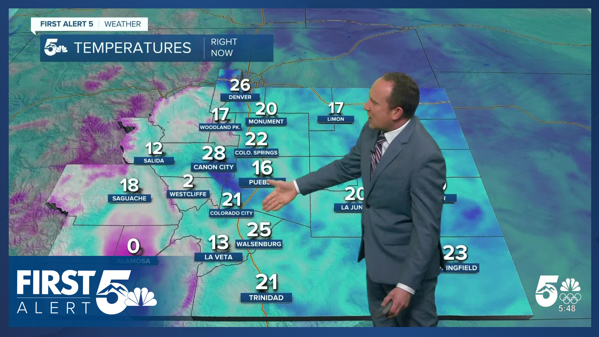
Colorado Springs forecast: High: 47; Low: 18. Less windy on Friday, with sunshine giving way to increasing clouds tonight and the potential for patchy freezing fog.
Pueblo forecast: High: 52; Low: 17. Temperatures will warm comfortably into the lower 50s on Friday, with sunny skies during the giving. A backdoor cold front will bring the potential for freezing fog later tonight.
Canon City forecast: High: 52; Low: 22. Sunshine and light breezes will make for a gorgeous end to the week in Fremont County. Highs today will warm into the lower 50s.
Woodland Park forecast: High: 38; Low: 18. Chilly sunshine during the day will give way to increasing clouds this evening as overnight temperatures tumble all the way down to the 10s.
Tri-Lakes forecast: High: 30s/40s; Low: 10s/20s. It will be a sunny start to our Friday, with the sunshine game expected to remain strong into the afternoon hours. A backdoor cold front will move in from the northeast this evening, bringing the potential for areas of frozen fog.
Plains forecast: High: 40s/50s; Low: 10s/20s. Breezy on the Plains today as we'll be the first to feel the effects of an incoming cold front dropping in from the northeast. Gusts today will increase to around 30-35 mph. A few flurries will be possible this afternoon, along with the potential for flurries and freezing fog later tonight.
Walsenburg and Trinidad forecast: High: 40s; Low: 10s/20s. Sunny and not as windy on Friday, with temperatures this afternoon expected to top out in the 40s.
Mountains forecast: High: 20s/30s; Low: 10s. A sunny and cool day can be expected in the mountains on Friday, with temperatures this afternoon topping out in the 20s and 30s. North wind gusts today will be around 25-35 mph.
Extended outlook forecast:
Freezing fog is possible on Saturday morning which will otherwise start off cold and cloudy with temperatures in the teens. These temperatures will warm slowly until the fog and low cloud cover burns off through the morning. But, by the afternoon, skies clear as the front swings back east and out of Colorado. Your highs warm to the low 50s.
A warming trend continues through Monday as upper level ridging remains to the west. A front will move in Monday night and has a bit of moisture behind it. Therefore, a few weak snow flurries are possible on Tuesday. A secondary wave of moisture will move into the mountains Tuesday night.
____
Curious about the First Alert 5 Weather Storm Impact Scale? Check out our cheatsheet explainer.
Watch KOAA News5 on your time, anytime with our free streaming app available for your Roku, FireTV, AppleTV and Android TV. Just search KOAA News5, download and start watching.
