

Today’s Forecast:
Not as cold on Friday as the snow from this week's storm will continue to melt away from Southern Colorado. Highs on Friday will warm into the 30s and 40s.
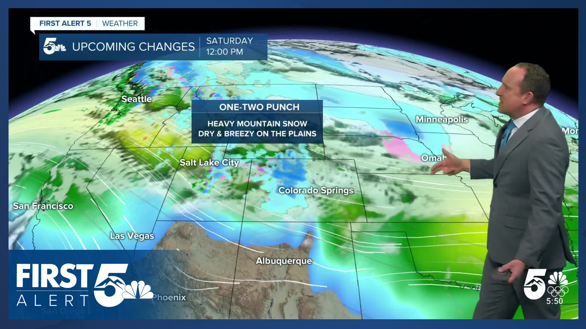
Tonight will be cold, with increasing southwest winds. Lows will drop down to the 10s and 20s across the Plains. While it will stay dry tonight in Southern Colorado, snow will increase in the mountains as a major snowmaker picks up across the high country into Saturday.
Colorado Springs forecast: High: 40; Low: 20.
Mountain wave clouds lead to a partly sunny Friday in Olympic City U.S.A. as we continue to slowly thaw out from our recent winter storm. Expect patchy black ice on secondary roads, bridges, and overpasses this morning. North winds at 5-10 mph this morning, shifting northeast this afternoon.
Pueblo forecast: High: 38; Low: 17.
Areas of patchy fog this morning in the Steel City should dissipate before the afternoon. Otherwise, a partly cloudy end to the week. Expect some slick patches on side streets this morning, that should largely melt by afternoon. Northwest winds at 5-10 mph.
Canon City forecast: High: 43; Low: 23.
Mostly sunny this morning, partly cloudy this afternoon. Northwest winds at 5-10 mph.
Woodland Park forecast: High: 36; Low: 15.
Mostly sunny and chilly, with northwest winds at 10-15 mph.
Tri-Lakes forecast: High: 30s/40s; Low: 10s/20s.
Partly to mostly cloudy through the day, due to mountain wave clouds rolling past the area. This is very common when the winds at the height our airplanes fly at are out of the northwest as they are now. At the ground, winds are also out of the northwest today, at 5-10 mph.
Plains forecast: High: 40s; Low: 10s/20s.
Areas of fog with the potential for dense fog in the lower Arkansas River Valley early today. Then clearing skies and becoming mostly sunny through early afternoon, then becoming mostly cloudy. North winds at 10-15 mph.
Walsenburg and Trinidad forecast: High: 30s/40s; Low: 10s/20s.
Mostly cloudy early this AM becoming mostly sunny this afternoon and then mostly cloudy again this evening. Northwest winds at 5-15 mph, gusting to 35 mph this morning.
Mountains forecast: High: 30s; Low: 10s/20s.
In the southern mountains - skies today will be mostly sunny and it will be breezy. North winds at 5-10 mph in the valleys, but 10-20 mph on the higher slopes. Snow will impact the central and northern mountain ranges today, becoming heavy this evening.
Extended outlook forecast:
Winter Storm Warnings will remain in effect from Friday evening into the day on Saturday in the mountains, with totals expected to range between 6-14" for the I-70 corridor and Monarch Pass area. On top of the heavy snowfall, wind gusts to 55 mph will also create hazardous driving conditions into and out of the mountains on Saturday. Travel is not recommended.
In Southern Colorado, we'll be on the dry, downslope side of Saturday's storm. Temperatures will warm into the mid to upper 40s along I-25 under partly to mostly cloudy skies. It will be breezy on Saturday, with NW wind gusts around 20-30 mph. If we do see any snow in the Pikes Peak Region, it would be towards Teller County, with only a 10% chance of snow on Saturday in El Paso County.
Highs will cool from the upper 40s on Saturday down to the lower 40s on Sunday in Colorado Springs. Next week looks mild, dry and breezy as highs are expected to warm into the 50s by next Tuesday from Colorado Springs to Pueblo.
____
Curious about the First Alert 5 Weather Storm Impact Scale? Check out our cheatsheet explainer.
Watch KOAA News5 on your time, anytime with our free streaming app available for your Roku, FireTV, AppleTV and Android TV. Just search KOAA News5, download and start watching.
