


Live Weather Blog:
We're now seeing the coldest air of the weekend settle in this morning. We'll update this story through the morning, but the worst is about to be behind us.
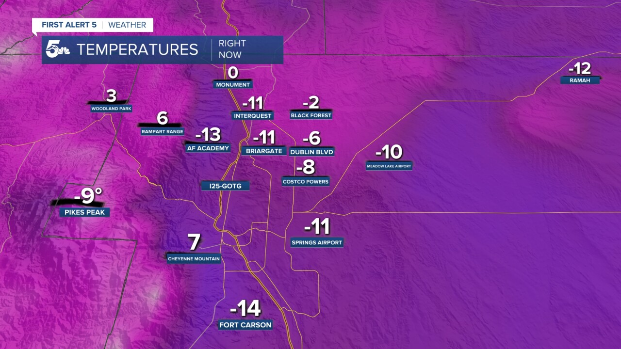
Monday: 6:30 a.m. | Temperatures have bottomed out through southern Colorado with every low elevation area below zero this morning.

It's actually colder this morning in parts of Colorado Springs and the plains than it is at the summit of Pikes Peak.
Monday 5:30 a.m. | Wind Chill Warnings and Advisories are in effect through 11 am today due to the extreme cold in the region.

Sunday 9:40 p.m. | Based on how cold it is already, I've made some adjustments to tonight's overnight lows. This is major folks!
Based on current temps, I've adjusted the forecast lows way, way down across Southern Colorado. Is this the coldest air that you've even seen? Let me know! #cowx pic.twitter.com/UN7a3cuKoK
— Alan Rose (@AlanRoseWX) February 15, 2021
Sunday 5:15 p.m. | With an overnight low of -13 degrees in Colorado Springs, there's a really good chance that we'll break a new record on Monday.
It's a pretty safe bet that we're going to set a new record low in Colorado Springs on Monday, but we shouldn't get anywhere close to a record in Pueblo. #cowx pic.twitter.com/JI9Nds3V4V
— Alan Rose (@AlanRoseWX) February 14, 2021
Sunday 3:25 p.m. | The National Weather Service has added El Paso County to tonight's Wind Chill Warning. The warning is set to go into effect at 5 p.m.
#BREAKING El Paso County has been added to tonight's Wind Chill Warning. Wind chill values in the -25 to -35 degree range can lead to frostbite in 15-30 minutes. #cowx pic.twitter.com/LJxC4zzzAb
— Alan Rose (@AlanRoseWX) February 14, 2021
Sunday 8:30 a.m. | Some snow totals are starting to come in this morning. Not included in the tweet below are:
Securty 1"
Wetmore 1.2"
Blende 1.3"
Canon City 1.5"
Peterson AFB 1.5"
W Pueblo 1.7"
Colorado Springs, Broadmoor 1.9"
Buena Vista 1.9"
Lamar 2"
Colorado City 2"
Rocky Ford 2.5"
Higbee 2.8"
Salida 3"
Crestone 4.4"
Snow totals starting to trickle in this morning. It will still be lightly snowing through the rest of the morning. #COwx pic.twitter.com/fU57UR6NWu
— Alex O'Brien (@WXAlexOBrien) February 14, 2021
Sunday 6:30 a.m. | Snow was widespread overnight in our region, leaving all roads snow-covered this morning. The intensity was lighter than forecast, with snow totals in the plains generally between 1-3 inches. Please send your snow reports to weather@koaa.com. The snow is so light that it is easily blowing and reducing visibility on the roads.
Morning wind chill values are in the negative teens and 20s.
Saturday 8:30 p.m. | Even though it's very cold tonight, the worst is yet to come, with the potential for new record lows being set in Colorado Springs the next few days.
Setting a record low in Colorado Springs tomorrow is possible, but much more attainable Monday morning as the forecast low is -11 degrees, 3 degrees greater than the current record. #cowx pic.twitter.com/fKJObTGSC6
— Alan Rose (@AlanRoseWX) February 14, 2021
Saturday 7:00 p.m. | UPDATED look at the snowfall forecast for the next 24 hours. Most of the snow will fall through early Sunday morning.
Light, fluffy snow will fall through Sunday morning before tapering off to flurries. Snow totals will be pretty high across the region, especially the far east Plains and Sangres. #cowx pic.twitter.com/oMvDCcxJBz
— Alan Rose (@AlanRoseWX) February 14, 2021
Saturday 6:10 p.m. |UPDATED wind chill map for Southern Colorado.
The current wind chill in Monument is -19 degrees, and there's also snow falling tonight! #cowx #arcticblast #polarplunge pic.twitter.com/CAdrCqAvoM
— Alan Rose (@AlanRoseWX) February 14, 2021
Saturday 5:30 p.m. | Expected Winter Weather Impacts for Southern Colorado through midday Monday. Snow and cold will be the main players.
Our current winter storm will bring high snow impacts and extreme cold/wind chill impacts to Southern Colorado through midday Monday. The heaviest snow will occur through early Sunday morning. #cowx pic.twitter.com/YT42pDhkTi
— Alan Rose (@AlanRoseWX) February 14, 2021
Saturday 5:15 p.m. | Snow has arrived and will become more widespread and heavier this evening over Southern Colorado.
Saturday 7:00 a.m. | Temperatures continue to drop and snow will become a hazard this evening.
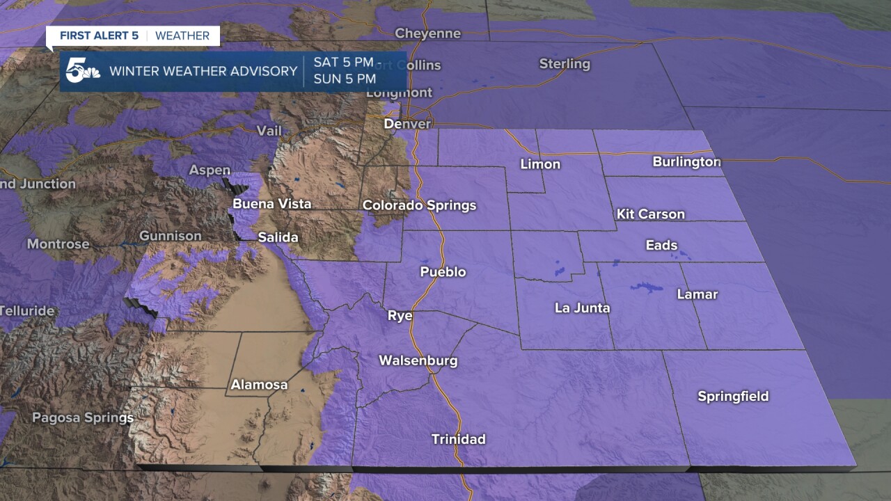
A WINTER WEATHER ADVISORY will go into effect at 5 pm and end Sunday at 5 pm. Snow will be very light and fluffy and stack up easily. Roads will have a hard time melting, if they do at all.

Friday 12:45 p.m. | Wind chill advisories have been expanded west. They now include the counties of El Paso, Pueblo, Huerfano, Las Animas, Crowley, Otero, Bent, Prowers, Kiowa, and Baca. This advisory goes into effect 11 pm tonight through Monday at 11 am. During the coldest hours in this time frame, wind chill values may dip to 30-35 below zero. Frostbite can occur within 30 minutes under these conditions.
Friday’s Forecast:
Arctic air slipped under already cold air last night in the plains and generated light snow and flurries right up into the I-25 corridor! We will keep the cold air around all day today, with highs expected to top out in the teens at best for cities and towns 6,000 feet and below.
There could be occasional flurries through the day today, and then again tonight when temperatures fall even lower. Colder air and heavier snow is expected to fall through the weekend, details can be found at the bottom of this story.
COLORADO SPRINGS: High: 18; Low: 2. Very cold and breezy today with cloudy skies and occasional flurries through the afternoon. Overnight lows will fall to the single digits and we could have more flurries and fog.
PUEBLO: High: 16; Low: 2. Very cold today with light winds, cloudy skies, and the chance for more occasional flurries. Tonight we'll see lows drop to the single digits and we could get more patchy fog and flurries.
CANON CITY: High: 24; Low: 14. Cold and breezy today with cloudy skies and occasional flurries. Tonight we'll see temperatures drop into the teens but there could be more fog and a few flurries.
WOODLAND PARK: High: 36; Low: 20. Cold and windy today with dry but cloudy skies. Overnight we'll see temperatures drop into the lower 20s to the higher teens, and we should stay dry.
TRI-LAKES: High: 20s; Low: <10. Really cold today and breezy at times with cloudy skies and a small chance for stray flurries. Overnight patchy fog and flurries are possible with single-digit temperatures.
PLAINS: High: 10/20s; Low: <10. Extremely cold air will remain in the plains today and tonight with teen and single-digit high temperatures during the day and negatives for the overnight lows. We'll see patchy fog and flurries during the day today, but especially overnight.
WALSENBURG/TRINIDAD: High: 30s; Low: <10. It'll be cold from Walsenburg to Trinidad today but not as much as what we'll see north and east. There could be patchy fog and a few flurries during the day and into the overnight hours.
MOUNTAINS: High: 40s; Low: 20s. Heavy snow is forecast through the central and western mountains today, and even the Sangres could see several inches. Travel on I-70 and connector highways west like 24 and 160 will be very slick the farther west you go, including passes like Wolf Creek and Monarch. It'll be windy over the mountains which will only make travel in the high country more dangerous. Even more snow is expected in the high country through the weekend with very cold temperatures and strong winds.
Weekend Outlook:
Colder air and heavier snow is forecast to hit Colorado through the weekend.

Here in southern Colorado, our heavy snow starts falling Saturday evening and lasts through early Sunday afternoon. We could see several inches along I-25, but the heaviest snow will be in the plains near the CO/KS border, and around the Wet and Sangre De Cristo Mountains.
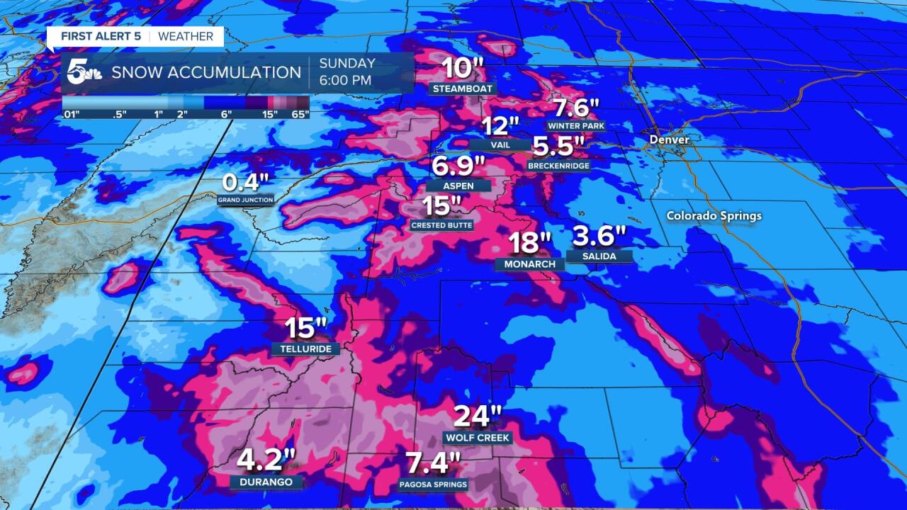
Even colder snow is forecast to fall across the ski areas from Friday through Sunday. Not only could we see many areas get between 1 to 2 feet of snow, we would also have strong winds creating blizzard-like conditions for drivers.

Temperatures will fall into the teens at best on Saturday across the lower elevations, but the coldest day in the forecast is on Sunday. Single-digit high temperatures are expected Sunday afternoon, and this is with the 2 to 4 or 3 to 5 inches of snow we're expecting along I-25 from Saturday through Sunday.
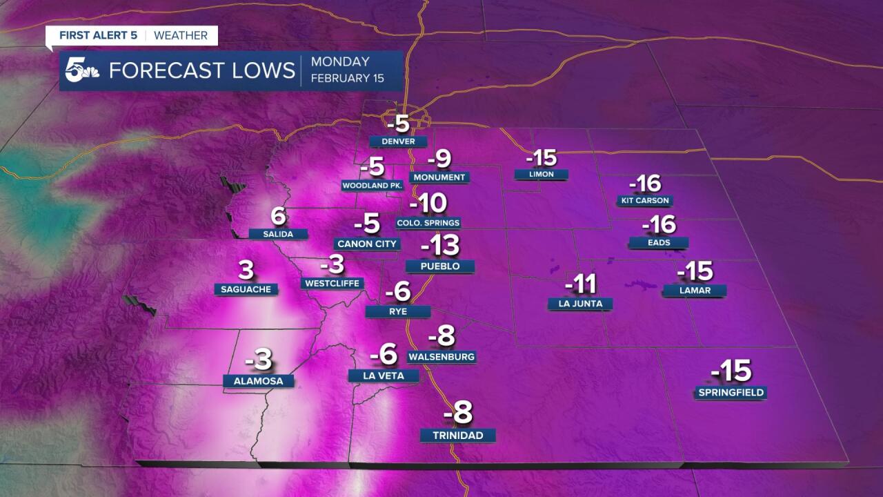
The coldest temperatures of the weekend will occur Sunday night through Monday morning. Lows in the deep negative could result in wind chills between -15 to -30 from I-25 east into the plains.
KOAA News5 on your time, streaming on your Roku, FireTV, AppleTV and AndroidTV.
News5 App | First Alert 5 Weather App | Youtube | Facebook | Instagram | Twitter
