Tonight’s Forecast:
The forecast is on track and we’re still tracking a powerful winter storm system that will slam the plains the hardest tonight into tomorrow morning. Heavy snow, strong wind and even some ice will make travel east and south of Pueblo county dangerous tonight.
Rain in the plains will continue off and on through the afternoon, while the I-25 corridor and northern mountains in our region stay dry until late this afternoon. Snow is moving up from New Mexico and will arrive to the San Luis Valley and southern mountains first, eventually then moving east into the plains overnight. We will also turn the rain in the plains into a brief freezing rain and then snow overnight.
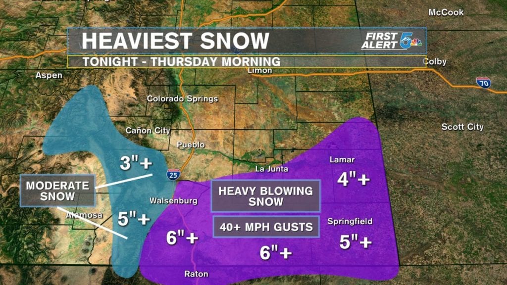
The heaviest snow tonight will occur over Las Animas and Baca counties, but Huerfano, Otero, Bent and Prowers counties should be prepared for the possibility of very heavy snow as well. The winds will be gusting out of the north between 30 to 40 mph with gusts higher than that at times through the plains.
The Pikes Peak region should expect snowfall, and while at times it may look and actually come down heavy this evening, snow totals are still expected to remain under an inch for most places, maybe 1 to 2 inches over Monument Hill
COLORADO SPRINGS: Tonight’s Low – 20. Tomorrow’s High – 32. Blowing snow arrives this evening with wind gusts in the 30 to even 40 mph range. Accumulation of snow will be low, generally at or under 1 inch but visibility from blowing snow could be very low. Wind Chills will be near zero by tomorrow morning.
PUEBLO: Tonight’s Low – 23, Tomorrow’s High – 35. Brief rain turning to blowing snow arrives this evening with wind gusts up towards 40 mph possible. Accumulations of snow remain pretty low but Pueblo has a better chance of seeing 1 to 2 inches compared to the Springs. Wind chills will be in the low teens in the morning.
CANON CITY: Tonight’s Low – 22, Tomorrow’s High – 34. Very light snow and gusty winds are still forecast for Canon City tonight, but a limited weather impact is expected. Snow accumulations should stay well below 0.5 inches and wind gusts will stay under 20 mph.
WOODLAND PARK: Tonight’s Low – 11, Tomorrow’s High – 25. Blowing, light snow arrives to Woodland Park tonight but snow accumulation is expected to stay at or under 1 inch. Wind gusts will blow in the 20 mph range.
TRI-LAKES: Tonight’s Low – 10s, Tomorrow’s High – 20s. Blowing snow arrives this evening with wind gusts in the 30 mph range. Accumulating snow is expected, with around 1 to 2 inches possible by midnight tonight. Any drives over Monument Hill could easily be slick with visibility down under one mile.
PLAINS: Tonight’s Low – 20s, Tomorrow’s High – 30s. Heavy snow, strong winds and brief icing are all in the cards for the plains tonight. The heaviest snow will likely fall across Las Animas, Baca and Prowers counties, but Otero and Bent should be prepared for heavy snow and dangerous travel conditions tonight. Anyone in the Winter Storm Warning could see a range of snow between 4 to 7 inches. Winds will gust tonight in the 40 to even 50 mph range and snow falling over brief ice will lead to treacherous driving on both highway 50 and 160.
WALSENBURG/TRINIDAD: Tonight’s Low – 10s, Tomorrow’s High – 30s. Heavy snow and strong winds arrive tonight to the southern I-25 corridor and southern mountains. Trinidad and areas in Las Animas county will likely see more snow compared to Walsenburg, but Walsenburg could still easily see over 3 inches of snow. Trinidad should prepare for snow totals ranging from 4 to 7 inches by early Thursday morning. Drives on I-25 south through Raton Pass are expected to be dangerous tonight, as well as drives east and west on highway 160.
EXTENDED OUTLOOK: Occasional flurries Thursday through Friday morning, becomes a steadier snow later Friday. The biggest snow on Friday will occur over the southern mountains, but very cold and saturated air could still squeeze out a few inches around the Pikes Peak region. The weekend looks cold on Saturday but back to the 40s by Sunday with VERY cold mornings. There’s a small chance for snow New Years eve but New Years day looks dry.
