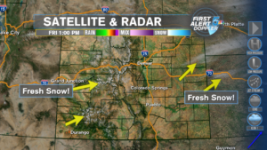
The above image is a satellite image of today, from space. Zero clouds. But here’s the thing, when we change the mode from infra red (heat-based) to visible, you see whatever there is to see, and since there is NO cloud cover, you see the white, which is fresh snow from a few days ago! Along the mountain peaks west, and in extreme eastern Colorado too. Always something to see, learn, enjoy!
Forecast: After a nice TGIF, Saturday will feature even warmer temps, jumping into the 50s and 60s. it’s not going to last, as the temps plummet Sunday & Monday. A bubble of high pressure will keep our skies fair through Saturday night, end because of it’s position relative to us, the winds are down the slopes, which compresses and warms the air. However, it keeps truckin east, and a cold front snaps us back into reality Sunday. It also reverses the wind, and combined with a few pieces of energy embedded in the jet stream, brings us some occasional light snow.
That’s our only precipitation in the forecast, through next Friday…
COLORADO SPRINGS: Low – 20, High – 60. Clear, cold night! Sunny, terrific Saturday.
PUEBLO: Low – 17, High – 63. A clear, cold tonight! A sunny, warm-er Saturday.
WOODLAND PARK: Low – 22, High – 50. Clear, frosty tonight. Sunny, a bit warmer Saturday.
TRI-LAKES: Low – 19, High – 52. Clear sky, cold tonight. Sunny Saturday.
PLAINS: Low – 22, High – 63. Clear tonight. Sunny, much warmer Saturday.
WALSENBURG/TRINIDAD: Low – 26, High – 62. Clear & cold tonight. Sunny, noticeably warmer Saturday.
EXTENDED OUTLOOK: After a major temp plunge Sunday & Monday, Tuesday is a transitional day, and it turns amazing for next Wednesday through…who knows!
