Today’s Forecast:
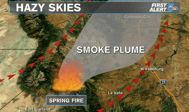
High heat and strong winds in the forecast today with hazy skies possible as smoke from the Spring Fire heads north. Strong afternoon surface winds out of the south work together with southerly upper level winds to blow smoke up to the north and northeast through the day today. If cities like Colorado Springs and Pueblo do not see hazy skies today, it’s definitely possible we will tomorrow morning as an overnight inversion pushes any smoke closer to the surface. High heat will be the biggest story of the day with both Springs and Pueblo likely to break temperature records.
COLORADO SPRINGS: High – 100; Low – 64. Extremely hot with the old record today sitting at 98 degrees. We’ll see a stronger afternoon wind south of the south boosting fire danger. Tonight the winds will lighten up and temperatures will fall to the 60s.
PUEBLO: High – 107; Low – 68. Extremely hot and dry today with a stronger breeze through the afternoon. The old record is 106 for today. Temperatures will stay very warm overnight with a lighter breeze. There are no fire advisories but fire danger will stay high through the evening.
CANON CITY: High – 104; Low – 69. Very hot, dry and windy today with high fire danger well into the evening. Temps stay very warm overnight.
WOODLAND PARK: High – 90; Low – 57. Very warm today with only a small chance for a mountain thunderstorm that would likely put down more wind than any rain. The winds will be stronger this afternoon and lighten up tonight with temperatures staying in the upper 50s.
TRI-LAKES: High – 90s; Low – 50s. Very hot and windy today, especially through the afternoon with temps cooling to the upper 50s tonight.
PLAINS: High – 100s; Low – 60s/70s. Extremely hot and dry today with strong winds through Bent, Prowers and Kiowa counties.
WALSENBURG/TRINIDAD: High – 100s; Low – 60s/70s. Very hot and windy today with very high fire danger. Isolated high based thunderstorms are possible but we would likely see just strong and gusty winds instead of rain with how dry the air is.
WEEKEND OUTLOOK OR NEXT WEATHER MAKER:
Cooler air moves into the upper atmosphere tomorrow and we’ll see things about 5 degrees cooler here at the surface. The winds will still be strong on Friday and we’ll likely see Red Flag Warnings return, especially in the southeast mountains through Friday evening. A cold front pushes in Saturday bringing 80s and 90s back to the lower elevations and small rain chances to the Front Range and far eastern plains.
RELATED LINKS:
| Drive the Doppler | Colorado Temperatures |
| 7-Day Forecast | National Temperatures |
| Weather Cameras | Wind Chills |
| Traffic | Wind Speeds |
| Closings and Delays | Photos |
| Take 5 to Prepare | Storm Safe |
