Today’s Forecast:
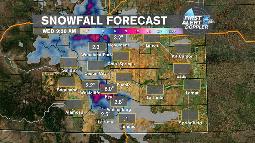
A cold front overnight brought chilling temperatures, strong winds, and trailing rain and snow impacting the tail end of your morning commutes. A line of snow in Denver will push south into the Rampart Range, northern Teller county, Monument Hill area and then Colorado Springs through the morning and then fade quickly and move east as our strong northerly winds dry it out. Monument Hill will see light snow this morning but Colorado Springs will have a mix of non accumulating wet snow and rain. We’ll be mainly dry through the region around noon but after 2pm rain and snow start returning to the mountains west of I-25 and then spill towards the interstate and south along in through the evening. The biggest snow accumulations will be in the Wet Mountains will snow totals over 6 inches possible! Woodland Park and Monument should expect totals between 1 to 3 inches through tonight and the Sangre De Cristo mountains should expect similar totals.
COLORADO SPRINGS: High – 67; Low – 33. Morning rain/snow mix with afternoon and evening rain to a rain snow mixture. Snow accumulation will be nothing to a dusting on the grass on the north side of the city. Temps fall to freezing tonight and a few icy spots
PUEBLO: High – 67; Low – 33. Isolate showers possible late this morning but we’re mainly dry until 5pm tonight when heavier rains will return and continue well into the early evening. Temps drop near freezing tonight so no icy roads are expected.
CANON CITY: High – 67; Low – 33. Late day and early evening showers are expected with a possibly brief wet and non accumulating snow possible after 5pm tonight. Roads will stay wet and not icy tonight.
WOODLAND PARK: High – 67; Low – 33. Brief light snow this morning but the larger accumulating snow will occur later today and into tonight. Slick roads for the evening commute should be expected and things could get icy. Snow totals between 1 to 3 inches are expected, an isolated 4" total is possible.
TRI-LAKES: High – 67; Low – 33. Light snow this morning with I-25 mainly damp this morning and any snow will be light and mainly on the grass. Later this afternoon through tonight we’ll see bigger snowfall return and the evening commute could get icy. Snow totals between 1 to 3 inches are expected.
PLAINS: High – 67; Low – 33. Light rain this morning with heavier rain returning through the afternoon and especially the overnight hours. Temperatures will likely stay warm enough to where all precipitation will stay as rain.
WALSENBURG/TRINIDAD: High – 67; Low – 33. Mainly dry this morning with rain returning this afternoon and a turn to snow likely especially for areas in the higher elevations. Walsenburg could see 1 to 3 inches of snow through tonight, Trinidad likely less than 1 inch.
WEEKEND OUTLOOK OR NEXT WEATHER MAKER:
Dry and nice for Wednesday with highs returning into the 60s under sunny skies. Thursday we’ll see a cold front blast strong winds through the area with a few spotty showers possible for areas like Colorado Springs and Teller county down the Front Range. The weekend still looks very warm with highs in the 70s and 80s roaring back into the area.
RELATED LINKS:
| Drive the Doppler | Colorado Temperatures |
| 7-Day Forecast | National Temperatures |
| Weather Cameras | Wind Chills |
| Traffic | Wind Speeds |
| Closings and Delays | Photos |
| Take 5 to Prepare | Storm Safe |
