A nasty winter system is forecast to move into southern Colorado this weekend and it could drop the first substantial snow of the season. Meteorologist Sam Schreier will step through the raw model output and discuss the amounts he believe will fall.
This system is going to pack a lot of wind, cold, and yes snow. Saturday would be a good idea to take care of any work outside such as flushing your sprinkler lines, putting away summer furniture, preparing fragile plants, and making plans for your pets.
The modeling has been fairly consistent all week with this system. The biggest accumulators will be the Sangre De Cristos, Wet Mountains and areas south towards the Raton Mesa. Monument Hill will also likely do well as that north wind will ramp right up the terrain.
Breaking Down The Model:
As of Friday morning, here are the current numbers being forecast by the KOAA RPM model. As you can see, the model is favoring the high terrain of the Sangres, Wets and Raton area, as well as Monument Hill. Small accumulations will be likely through Colorado Springs and areas out east along highway 94 and north of highway 50.

What Sam Thinks – Pikes Peak Area:
This is a bit of a tough one. The winds and moisture will be coming straight out of the north, meaning the Palmer Divide is going to soak up and physically block a lot of moisture from moving into the Springs. That being said, Colorado Springs should still expect a nice range of 1 to 2 inches across the city with lower accumulation south and greater accumulation north.
Teller County will absorb whatever moisture makes it over the front range mountains west of Colorado Springs. Woodland Park should expect anywhere between 1 to 3 inches, but there is large uncertainty for this area.

What Sam Thinks – Arkansas River Valley:
Without the blocking wall of the Palmer Divide and Monument Hill, the Arkansas River valley and especially the mountains to the west, should get decent accumulation. Pueblo should receive a nice range of 1 to 3 inches through Sunday night. The largest accumulations will fall on the Wet Mountains, especially the eastern slopes.
Canon City has a high degree of uncertainty since the air will need to funnel in right from the east to get decent accumulation. Still, most modeling is and has been supportive of at least a couple inches through Sunday night.
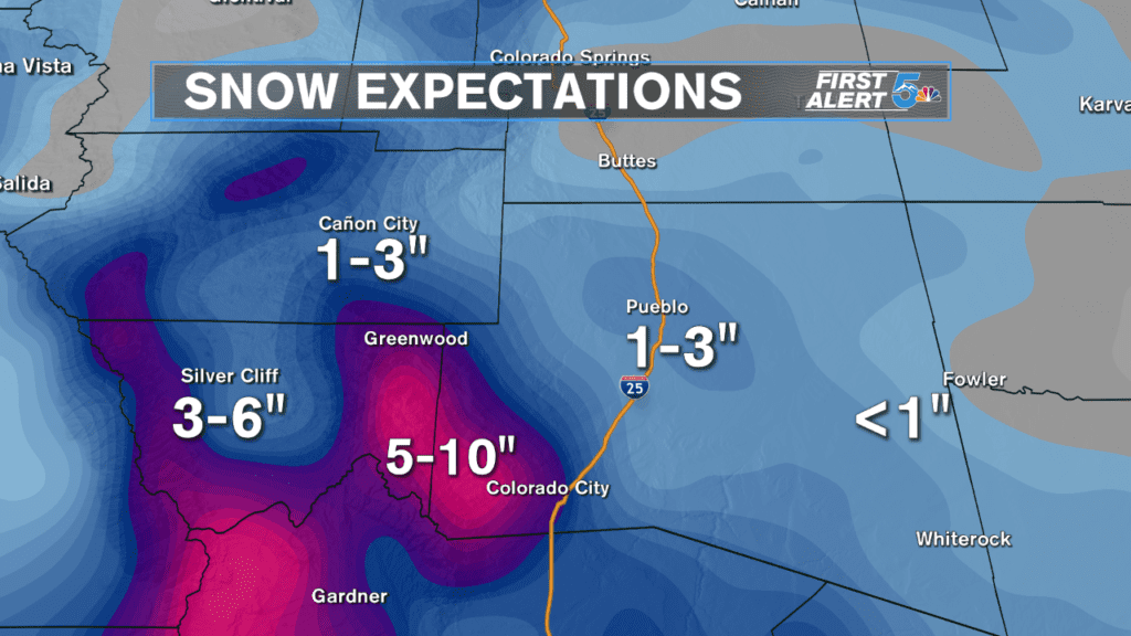
In case you are wondering, in the record books the earliest trace of snow in Pueblo was on September 10th in 1898, over a century ago! The earliest measurable snowfall in Pueblo occurred on September 17th in 1971 with 7.3 inches recorded.
What Sam Thinks – Southern I-25 Corridor:
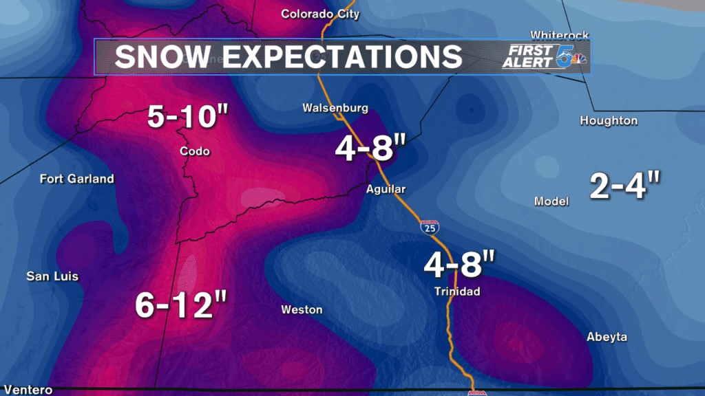
The Sangres, Raton Mesa and open space between Walsenburg and Aguilar should do very well this weekend. Cold, moist, northeast winds will slam snow right into the high terrain and produce heavy accumulation through Sunday night. La Veta Pass could be a nasty drive Sunday and Monday morning, so be extra careful if you commute through there.
What Sam Thinks – Plains Forecast:
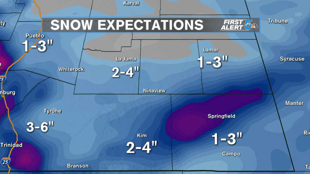
Snow in the plains should be modest to healthy with higher snow accumulations favoring areas south of highway 50. Of the bigger towns through the plains, La Junta will probably grab the most snow, unless a rogue heavy band sets up over Springfield.
As we get new model runs today and especially tomorrow, we’ll be able to fine tune our forecast numbers and give you a better idea of exactly how much will fall in your area. Stay tuned on air and online through the weekend, the First Alert 5 Weather Team will have your back.
RELATED:
Protect your plants: Recognize the signs a frost or freeze is on the way
Please take care of your pets as more winter weather approaches
