

Today’s Forecast:
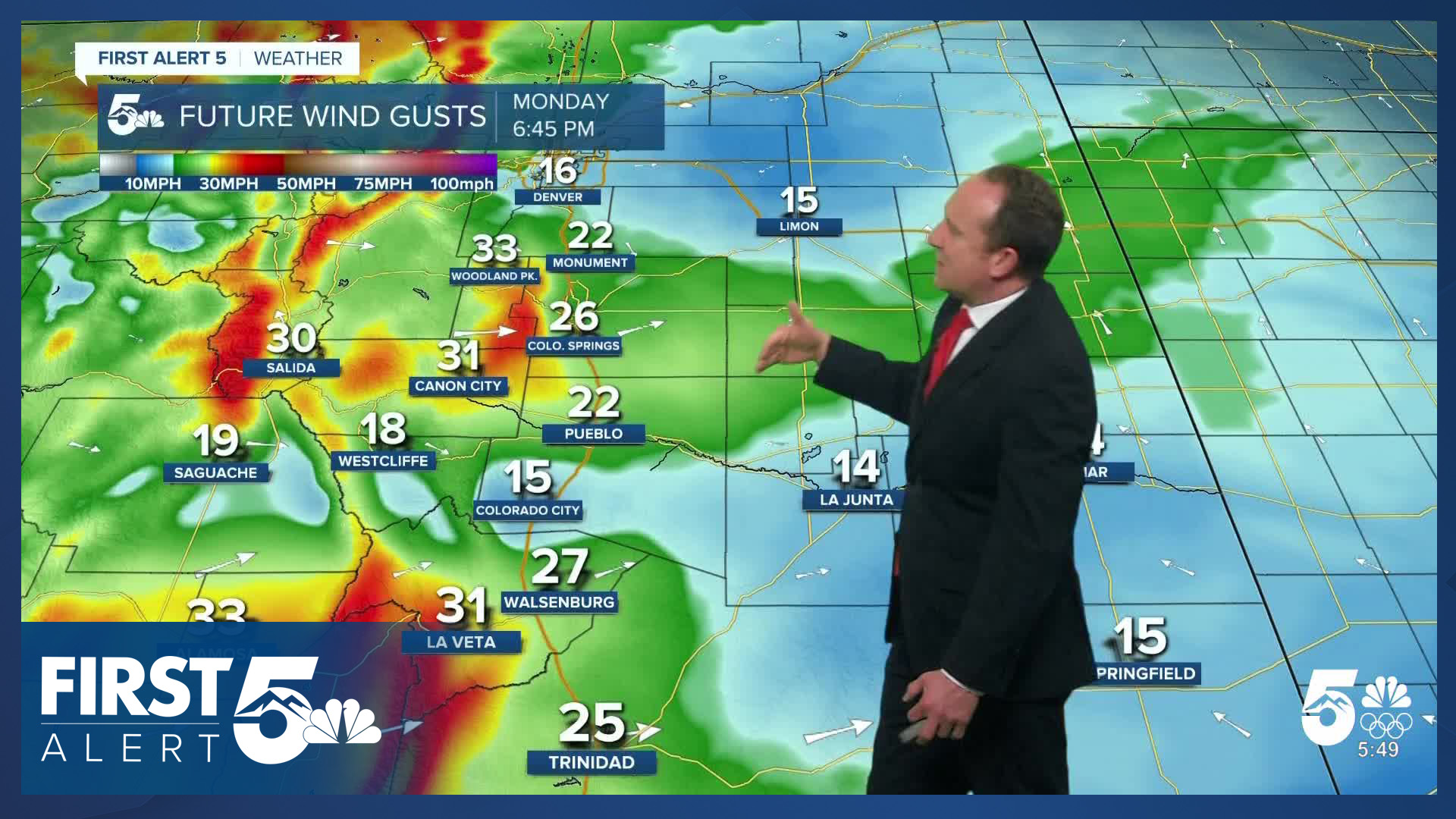
With increasing westerly wind across Colorado on Monday, areas east of the mountains will see a dry, warm and gusty start to the week. Highs on the Plains will warm well into the 70s today, with a few areas expected to top the 80 degree mark. Highs in the mountain valleys and higher elevation areas will warm into the 50s and lower 60s.
With peak wind gusts to 35 mph lowering relative humidity down to the single digits and teens, many areas outside of the mountains will see Red Flag Warnings today. For the southern I-25 corridor, these warnings will remain in effect from 10 am to 7 pm. For the El Paso, Pueblo, Fremont and Crowley counties, as well as the San Luis Valley, Red Flag Warnings will remain in effect from noon to 7 pm. Precipitation is not expected on Monday.
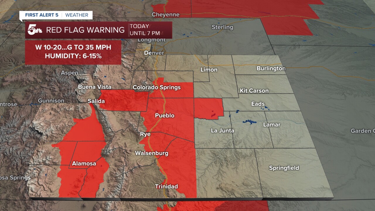
Colorado Springs forecast: High: 71; Low: 39. Warm, spring-like weather will continue on Monday. Highs in the lower 70s this afternoon will be well above our average high of 53 degrees. It will also be gusty on Monday, with a Red Flag Warning back in effect today from noon to 7 pm.
Pueblo forecast: High: 78; Low: 35. Downsloping wind will bring warm temperatures and sunshine to our forecast today. Afternoon highs will peak in the upper 70s, and a Red Flag Warning will be in effect today from noon to 7 pm.
Canon City forecast: High: 75; Low: 40. Red Flag Warnings return to our forecast starting at noon. The downslope wind will bring downslope warmth this afternoon as high temperatures climb into the middle 70s.
Woodland Park forecast: High: 60; Low: 32. Monday's forecast high of 60 degrees will be more like May than March. On top of today's mild temperatures, it will be breezy to gusty, with peak wind gusts this afternoon to 40 mph.
Tri-Lakes forecast: High: 60s/70s; Low: 30s. Unseasonably warm and gusty conditions on Monday will be matched by more wind and warmth on Tuesday. Highs both days look to top out in the 60s and very low 70s.
Plains forecast: High: 70s/80s; Low: 30s/40s. A warm and windy start to the week can be expected on the eastern Plains, with a Red Flag Warning in effect today for Huerfano, Las Animas and Crowley counties.
Walsenburg and Trinidad forecast: High: 60s/70s; Low: 30s/40s. Windy, dry and warm on Monday, with a Red Flag Warning in effect from 10 am until 7 pm. An approaching storm Tuesday may provide some brief fire danger relief, thanks to a few showers and thunderstorms.
Mountains forecast: High: 40s/50s; Low: 20s/30s. After snow last week, spring-like wind and warmth will return to the Wet Mountains and Sangres on Monday. Peak gusts this afternoon could top 45-50 mph in some areas.
Extended outlook forecast:
Tuesday looks busier than today, but for Colorado Springs, it might end up being on the quiet side compared to other parts of Southern Colorado. An area of low pressure that pinched off of Friday's storm will travel west to east from Arizona into New Mexico. The storm is expected to stay pretty far south, with only around a 10% chance of a shower in Colorado Springs. Areas south of Highway 50 and the eastern Plains will see slightly better chances for rain, thunderstorms and snow Tuesday afternoon. Our high in the Springs on Tuesday will still warm into the lower 70s.
Wednesday will be cooler following the passage of Tuesday night's cold front. Our high of 51 degrees will be the coolest of the week in Colorado Springs, and our only day below average. Temperatures will rebound back into the 70s and 80s late this week on the Plains, driven by more breezy to gusty downslope wind. This is likely to bring Red Flag Warnings back to Southern Colorado late this week as well.
____
Curious about the First Alert 5 Weather Storm Impact Scale? Check out our cheatsheet explainer.
Watch KOAA News5 on your time, anytime with our free streaming app available for your Roku, FireTV, AppleTV and Android TV. Just search KOAA News5, download and start watching.
