

Today’s Forecast:
Wave clouds are developing over the Pikes Peak Region this morning, extending down through Pueblo County. Although it is another cold morning - starting off in the 10s and 20s, temperatures at any given hour will be about 5-15 degrees warmer than they were at the same time Monday morning. Cold Canadian air is on its way out of Southern Colorado and today will be a good day to run errands, or do any necessary housework ahead of an incoming winter weather system that arrives tonight. Highs today will be near average - in the 40s and 50s.
Winds today will be out of the northwest, gusty in a few spots this afternoon near the mountains but not for most areas. Clouds will increase through the day as our next storm system approaches.
A few flurries will be possible as early as this evening - though the main snow event will start Wednesday morning.
Colorado Springs forecast: High: 48; Low: 25. Mostly clear skies this morning will give way to increasing clouds this afternoon, with highs today warming into the upper 40s. As we head past midnight, snow is likely to start for the Pikes Peak Region.
Pueblo forecast: High: 51; Low: 25. After a chilly day in the 30s on Monday, highs today will improve by as much as 10-15 degrees for the Steel City. Dry weather today will give way to snow by Wednesday morning.
Canon City forecast: High: 50; Low: 27. After a couple of inches of snow Sunday night and Monday morning, temperatures will warm significantly today, with our high this afternoon topping out near 50 degrees.
Woodland Park forecast: High: 44; Low: 16. Snowmelt warmth can be expected on Tuesday, driven by westerly winds this afternoon up around 10-15 mph. Tonight after sunset, we'll see the potential for light snow to develop, with heavier snow forming by Wednesday morning.
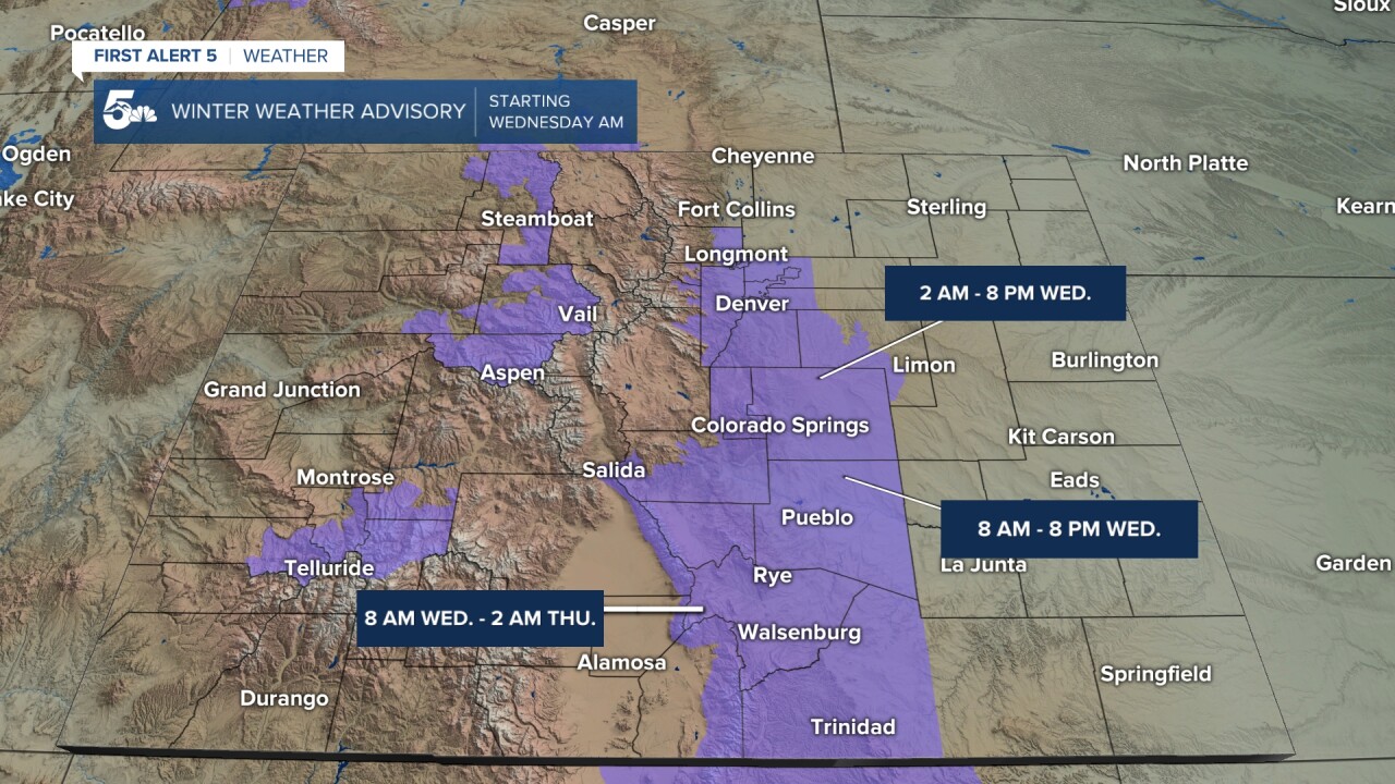
Tri-Lakes forecast: High: 40s; Low: 10s/20s. Overall, we'll see a nice looking Tuesday across northern El Paso County as highs this afternoon climb into the middle to upper 40s. Beginning at 2 am, a Winter Weather Advisory will go into effect, and this will continue until 8 pm Wednesday.
Plains forecast: High: 40s/50s; Low: 20s. Mostly sunny skies early will give way to increasing clouds and near average highs this afternoon. Even with our incoming storm bringing snow to the mountains today, snow is not likely on the Plains until tomorrow morning.
Walsenburg and Trinidad forecast: High: 40s/50s; Low: 10s/20s. Skies will be dry and it will be a bit on the breezy side on Tuesday, with westerly breezes warming highs into the 40s and 50s. Snow here should hold off until Wednesday morning.
Mountains forecast: High: 30s/40s; Low: 10s. Periods of light snow near the Continental Divide will spread east into the southeastern mountains this afternoon and evening as our next winter storm moves into the state. This storm will bring periods of moderate to heavy snow to the mountains later tonight and Wednesday, with some mountain summits expecting more than a foot of snow.
Extended outlook forecast:
Winter weather impacts will begin late this evening in the Pikes Peak Region before spreading southward overnight tonight. We expect this storm system to bring more notable impacts to you than our first winter storm of the season on Sunday night. The storm has multiple components. Currently, an upper level disturbance is over the Pacific Northwest. Today, the system will dive down toward Utah and strengthen. At the same time, another area of upper-level energy will move east through Idaho. Eventually, we'll have a strong low moving through Nevada and Utah, with another weaker disturbance off to the north of Colorado. This sets the stage for what happens here.
Temperatures tonight will drop below freezing - so we are not concerned about precipitation type, or concerned about whether or not snow will stick. Snow will stick, and precipitation will fall as snow.
A Winter Weather Advisory begins at 2 AM Wednesday for the Palmer Divide and N. El Paso county, and Teller County. For other parts of I-25, the advisory begins at 8 AM Wednesday. These advisories continue through 8 PM Wednesday night.
Heading into the overnight, energy ahead of the low pressure system to the west spreads east into Colorado. This upper level energy provides lift to the atmosphere - it helps to gradually push the air upward. At the same time, the northern upper level system will fling a cold front toward Southern Colorado. This front will approach from the east northeast, with airflow behind it coming from that direction, early on Wednesday morning. This upslope airflow is an essential must-have component for snow.
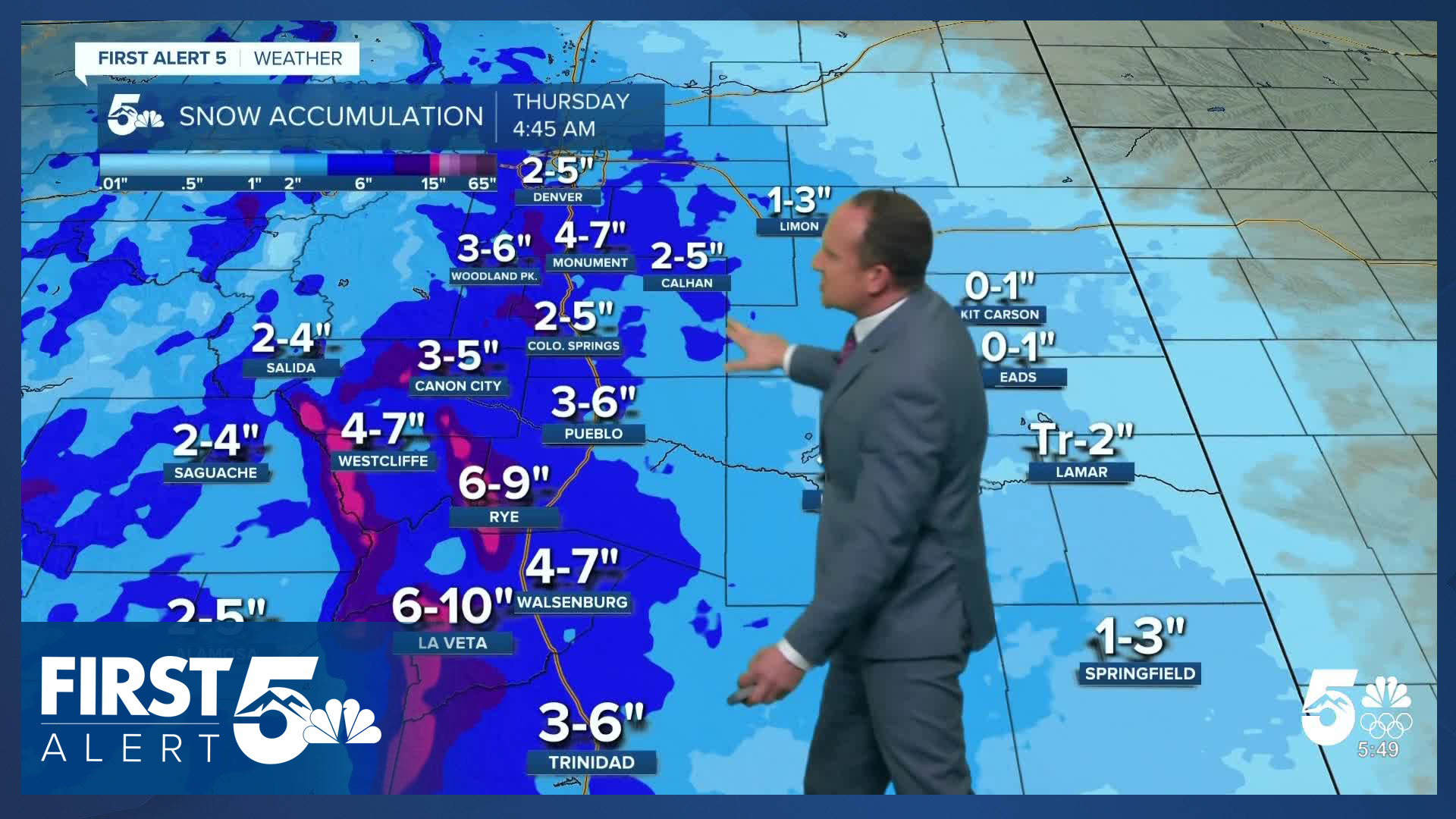
Snow will begin from north to south on Wednesday morning before sunrise, and is likely to be band-like, with accumulating snow in narrow corridors, and flurries in between those bands. Steadier snow will begin as the main western low gets closer, which provides extra lift to the atmosphere. It will snow throughout Wednesday, with intensity alternating through time as bits of energy flow over the mountains and the wind speeds adjust and slightly shift direction through the day. A widespread 2-5" is our current forecast for Colorado Springs, with isolated higher totals where those narrow bands of heavier precipitation set up. Higher totals are also likely over the Palmer Divide - with 4-7" likely, and again, the potential for more in some localized parts of the area.
Snow will come to an end by Wednesday evening. You should expect significant impacts to travel on Wednesday. Highs will remain below freezing all day for much of Southern Colorado.
It will remain cold on Thursday as skies clear. It will be mostly sunny with highs in the 30s and lower 40s.
Warmer weather will follow this weekend, with periods of snow for the high country and generally dry skies on the Plains.
____
Curious about the First Alert 5 Weather Storm Impact Scale? Check out our cheatsheet explainer.
Watch KOAA News5 on your time, anytime with our free streaming app available for your Roku, FireTV, AppleTV and Android TV. Just search KOAA News5, download and start watching.
