


Today’s Forecast:
Another major winter storm is impacting southern Colorado today. A heavy snow band has been affecting Colorado Springs this morning, with 1 inch per hour snowfall rates. This band has expanded along the US 24 corridor from the Springs towards Calhan. With low pressure is tracking south of the state today, moisture and energy is moving in from south to north. Snow will continue to fill in across the entirety of the viewing area through the morning. Along the eastern plains, snow will start off light, with heavier snow in our southern zones.
Snow will be relatively light, becoming heavier through the morning into the mid-afternoon. The heaviest snow will fall this afternoon on I-25, and this evening in the southern plains, which are under a Winter Storm Warning. The remainder of I-25 and most of the plains are under Winter Weather Advisories. Snow will end tonight as a cool and dry push of air passes the region. Snow will become lighter and more showery as the storm moves away. Snow totals will range from 4-8 inches region wide, with the highest totals occurring where snow bands set up. Clouds remain into early Sunday morning with a few remnant flurries possible as well. Highs today will remain below freezing, meaning snow should stick easily to surfaces through the day. This will also lead to high rain:snow ratios - that is to say, this will be a light and fluffy, easy to shovel snow.
Here is the latest First Alert 5 snow accumulations forecast for your city:
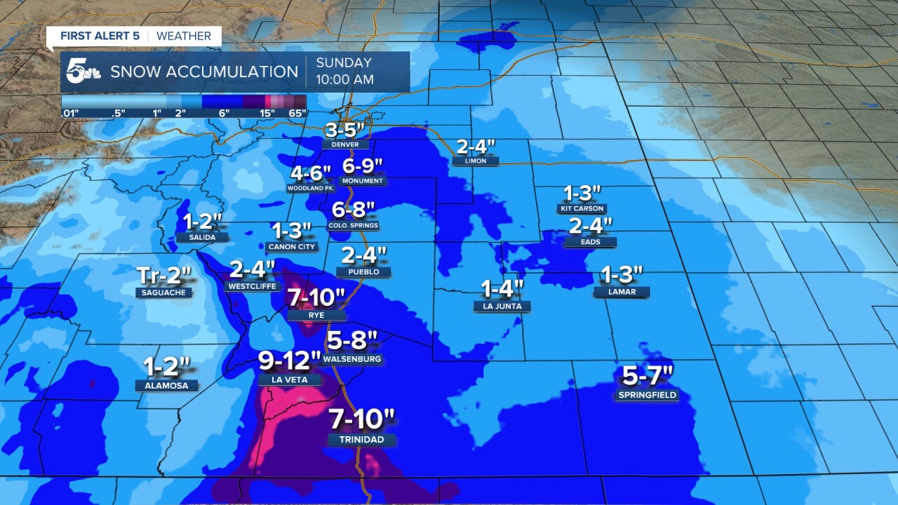
Colorado Springs forecast: High: 30; Low: 16.
*WINTER WEATHER ADVISORY* in effect until 5:00AM Sunday.
Heavy snow this morning due to a small-scale snow band over the region. Snowfall rates of 1 inch per hour will occur where the band is centered with 1/2 inch per hour rates on the fringes. Highs remain below freezing - this snow will accumulate on all surfaces. The City of Colorado Springs has a full call out in place for plows, meaning all plows are active and on the roads.
Pueblo forecast: High: 34; Low: 20.
*WINTER WEATHER ADVISORY* in effect until 5:00AM Sunday.
Snow showers, generally light to moderate in intensity, particularly after 12:00PM. East winds at 10-15 mph, with snow accumulating 2-4". Clouds remain overnight with a few snow showers remaining.
Canon City forecast: High: 34; Low: 22.
*WINTER WEATHER ADVISORY* in effect until 5:00AM Sunday.
Snow, light to moderate in intensity, with a few breaks, through 9:00PM with showers through 10:00PM. Snow accumulations of 1-4". The best chance for heavy snow will be from 3:00PM-6:00PM. Clouds remain overnight with a few remnant snow showers possible.
Woodland Park forecast: High: 26; Low: 7.
*WINTER WEATHER ADVISORY* in effect until 5:00AM Sunday.
Snow, moderate intensity at times, with a few breaks in the action. Accumulations of 4-6" by late Saturday as the storm moves out. Continuous snow should end by 9:00PM tonight, with snow showers still possible through midnight.
Tri-Lakes forecast: High: 20s; Low: Teens.
WINTER STORM WARNING in effect until 5:00AM Sunday.
Heavy snow this morning with a small-scale snow band over the region. Snow continues during the afternoon, heavy at times with additional bands.
Plains forecast: High: 30s; Low: 20s.
*WINTER WEATHER ADVISORY* in effect until 5:00AM Sunday - eastern plains.
WINTER STORM WARNING in effect until 8:00AM Sunday - southern counties...Baca, Las Animas, Huerfano.
Snow, heavy at times through the day, with the highest totals in the southern tier counties. A brief changeover to rain or a mix may occur during mid afternoon on the eastern plains, but this will still be a mainly snow event for you.
Walsenburg and Trinidad forecast: High: 30/32; Low: 18/20.
WINTER STORM WARNING in effect until 8:00AM Sunday.
Snow today, heavy at times, ending from 4:00AM - 7:00AM on Sunday. The heaviest snow will fall in the evening and overnight for you, with rates >1"/hr likely.
Mountains forecast: High: 20s; Low: 10s.
Snow, heavy at times, with very low visibility (<500 feet). Expect difficult to impossible travel conditions.
Extended outlook forecast:
Quiet weather returns for much of our week. Sunday will be clear but chilly with cold Canadian air in place. Highs will only top out in the 30s for most. Sledding will be good during the morning, errands will be best done in the afternoon. The work week will be quiet and seasonable with plenty of sunshine and temperatures in the mid to upper 40s for the first half of the week.
____
Curious about the First Alert 5 Weather Storm Impact Scale? Check out our cheatsheet explainer.
Watch KOAA News5 on your time, anytime with our free streaming app available for your Roku, FireTV, AppleTV and Android TV. Just search KOAA News5, download and start watching.
