


Tonight's Forecast:
After a comfortable mild day, clouds increase tonight with a cold front swinging through early on Thursday morning as our winter storm approaches. Snow showers will be likely in the high country and mountains overnight, with a spotty rain or snow shower along the Front Range as well, particularly in the Pikes Peak Region. A thunderstorm or two is possible along the eastern plains overnight with plenty of instability in place. Lows drop to around freezing for most with northerly winds as the cold front passes by. Winter Alerts go into effect tomorrow at 11AM.

Colorado Springs forecast: Low: 31; High: 47;
Mostly cloudy with rain and snow showers overnight in narrow bands. If you see a band, expect an inch or two of snow Thursday morning when you wake up. If you don't, you'll see nothing. Winds from the north at 10 - 15 mph following a cold front.
Pueblo forecast: Low: 30; High: 53;
Mostly cloudy with a morning flurry possible. Winds from the northwest at 10 - 15 mph.
Canon City forecast: Low: 25; High: 52;
WINTER WEATHER ADVISORY in effect from 11AM Thursday - 11PM Friday
Mostly cloudy with winds from the northwest at 10 mph. A few rain and snow showers are likely in the early morning, with more rain showers and thunderstorms - including thundersnow - during the afternoon.
Woodland Park forecast: Low: 22; High: 41;
WINTER WEATHER ADVISORY in effect from 11AM Thursday - 11PM Friday
Mostly cloudy with snow showers. A few rumbles of thunder are possible in the morning. Winds from the north at 10-15 mph.
Tri-Lakes forecast: Low: 20s; High: 40s;
WINTER WEATHER ADVISORY in effect from 11AM Thursday - 11PM Friday
Mostly cloudy with rain and snow showers overnight. Winds from the north at 10 - 15 mph.
Plains forecast: Low: 30s; High: Upper 40s;
Partly cloudy, becoming mostly cloudy by morning with rain showers in the morning. Thunder will be likely with any heavier shower. Winds from the north at 10-15 mph.
Walsenburg and Trinidad forecast: Low: 32/30; High: 48/54;
WINTER WEATHER ADVISORY in effect from 11AM Thursday - 11PM Friday
Partly cloudy skies with winds from the west at 10 - 15 mph.
Mountains forecast: Low: 20s; High: 40s;
WINTER STORM WARNING in effect from 11AM Thursday - 11PM Friday
Mostly cloudy with rain and snow showers arriving overnight, light at first and then increasing in intensity toward morning. Winds from the west at 10 - 15 mph.
Extended outlook forecast:
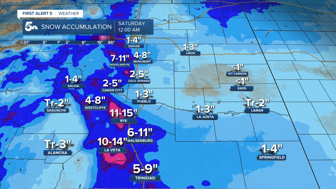
The winter storm we've spent much of the week telling you about arrives on Thursday - with multiple batches of rain and snow on the way, with a complicated set up. Temperatures start off in the low 30s with partly to mostly cloudy skies during the morning commute. A narrow band of moderate to heavy snow is likely early in the morning over northern El Paso County. This may result in an inch of snow along the Palmer Divide by rush hour. Thanks to the cloud cover and cold front, much cooler weather awaits us during the day with highs in the mid to upper 40s, a solid 15-20 degree drop from Wednesday's mild sunshine. We'll get a break in the action during the afternoon as a surface low spins up to the southeast. The exact track and strength of the surface low will matter for totals - a south jog would provide more upslope and much higher totals than we currently expect...farther north and we could see a further reduction.
Rain and snow showers re-develop develop during the afternoon. Thunderstorms are possible with good instability in place - and this precipitation may fall as rain, or snow. This will be the key to our snow totals forecast, as we could get quick accumulations if a heavy shower develops, drops temperatures, and quickly deposits some snow. Winter Weather Advisories and Winter Storm Warnings will be in effect tomorrow from 11AM through Friday at 11PM. Warnings for the mountains, advisories for the higher terrain in the area.
The best chances for moderate sustained snow with patchy heavy spots will be during the evening. Upslope flow will aid in the development of snow showers across the region as temperatures fall. Snow will accumulate during the evening into the morning on Friday.
Our storm continues Friday morning, but approaching dry air from the north with another cold front will start to endd snow across the area by lunchtime on Friday. However, we still have somewhat decent moisture flowing in from the Gulf Of Mexico as this happens, so there will be a bit of a "battle of the elements" Friday as the moisture competes with the dry air. However, since moist air is less dense than dry air...the dry air will ultimately win.
Following our storm, we'll warm up fast - into the upper 40s Saturday, upper 50s to low 60s Sunday with plenty of sun. A great weekend to get outside for sure. Remember to "spring forward" Saturday night - and although you'll lose that hour of sleep, you'll gain a sunset at 7:01 PM, and a beautiful day to enjoy it! By early next week, we'll be in the low 60s, with some breezy days on tap.
____
Curious about the First Alert 5 Weather Storm Impact Scale? Check out our cheatsheet explainer.
Watch KOAA News5 on your time, anytime with our free streaming app available for your Roku, FireTV, AppleTV and Android TV. Just search KOAA News5, download and start watching.
