


Today’s Forecast:
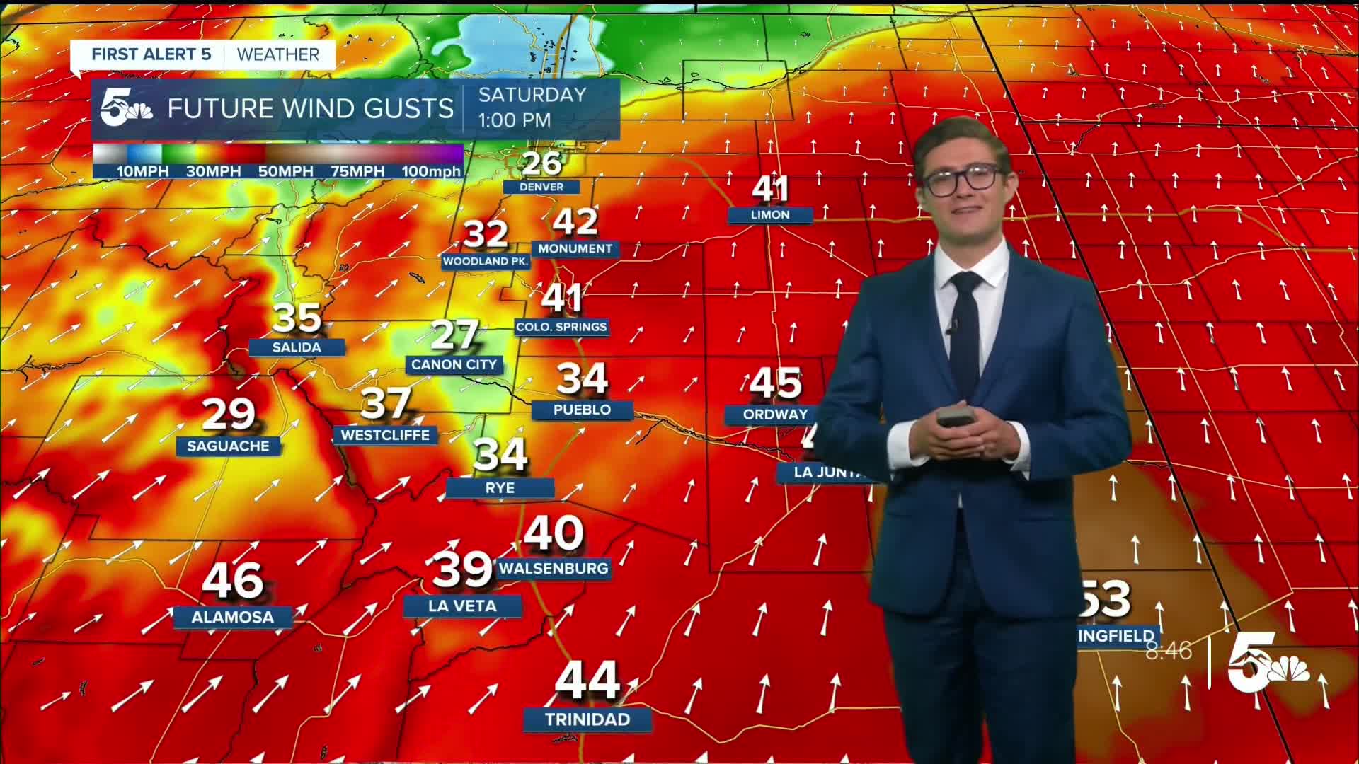
Wind! That's the main story today across southern Colorado, as the strongest storm of fall so far rounds the bend and moves into Colorado. Wind speeds at jet stream level are racing along at about 75 mph this morning, and this afternoon they'll peak near 100 mph (over western Colorado they're in the 120-130 mph range). We'll see downslope wind gusts begin around 10 AM this morning. They'll increase in intensity through mid-afternoon...peaking around 45-50 mph between 1 PM - 4 PM this afternoon on I-25 with a few gusts to 55 mph, and gusting to 55 mph more broadly on the plains. Be careful if you drive a particularly tall vehicle and you're headed either on I-25 or on a northeast to southwest oriented roadway close to the mountains.
The downslope winds will help to keep temperatures warm, even though our air mass is changing. Highs today remain above average with most spots in the upper 70s to middle 80s.
Skies will start off mostly clear on the plains, with clouds over the mountains. I expect us to see an isolated line of fast-moving showers with a few rumbles of thunder this afternoon. This broken line will move fast, so if you get any rain, it'll last less than 10 minutes! These isolated showers will still be capable of gusty wind (see the above jet stream) - with gusts stronger than the general wind you'll see during the day, and very small hail.
The first of two cold fronts arrives behind that broken line of showers tonight. It will cut down the wind and will help lead to a freeze in the San Luis Valley, where a Freeze Warning is in effect tonight from 3 AM - 9 AM.
Colorado Springs forecast: High: 78; Low: 41.
The wind is the big story today. Through the morning, generally from the south at 10-15 mph. By 11 AM, shifting southwest and increasing to 25-35 mph. Gusts to 50 mph are possible between about 1 PM - 5 PM today, though gusts to 40 are possible all afternoon. Mostly sunny through the morning, partly cloudy this afternoon. Isolated showers and thunderstorms possible, mainly between 2-5 pm.
Showers and storms will move very fast, so don't expect a long duration soaking rain. If you do get one of these storms it will mix down the wind from higher in the atmosphere, leading to briefly stronger wind gusts. It may be a smart choice to move lightweight objects like trashcans or lawn chairs, closer to your home today and out of the wind.
Pueblo forecast: High: 86; Low: 43.
A shingle shaker today in the steel city! South winds at 10-25 mph, increasing to 20-30 mph this afternoon from the southwest. Expect gusts to 45 mph, mainly between 1-5 PM, with a couple of 50 mph gusts possible - best chance on the west side of town. Sunny turning partly cloudy this afternoon with isolated showers, and a few rumbles of thunder possible from a very fast moving broken line of storms in the mid-afternoon. I'd suggest planning your day more around the wind than the chance of a 10 minute storm.
Canon City forecast: High: 80; Low: 45.
Mostly sunny this morning, patchy afternoon clouds. Not as windy as other spots, but still breezy. West winds at 10-15 mph in the AM, southwest winds at 20-30 mph in the afternoon, gusting to 35 mph. Isolated quick moving shower/storm possible in the afternoon, not long lasting.
Woodland Park forecast: High: 66; Low: 32.
Gusty with southwest winds at 10-20 mph, increasing to 20-30 mph this afternoon and gusting to 40 mph. Sunny this morning, partly cloudy this afternoon. A quick shower/storm is possible in the early afternoon with gusty wind.
Tri-Lakes forecast: High: 70s; Low: 30s.
Very windy today. South winds, first at 10-20 mph through mid-morning. By late morning shifting southwest and increasing to 25-35 mph. Gusts of 50-55 mph are possible from 1-5 PM; be careful if you drive a tall vehicle. Mostly sunny in the AM, partly cloudy in the PM, with an isolated shower or weak t-storm possible...quick moving, mainly producing gusty wind.
Plains forecast: High: 80s; Low: 40s/50s.
Very windy today. South winds at 20-35 mph in the morning, turning southwest in the afternoon with gusts to 55 mph. Mostly sunny turning mostly cloudy tonight.
Walsenburg and Trinidad forecast: High: 79/80; Low: 43.
Gusty today. Southwest winds at 15-25 mph, increasing to 20-30 mph this afternoon and gusting to 45 mph. Stronger gusts are possible over Raton Pass and La Veta Pass. Sunny, becoming mostly sunny this afternoon with an isolated shower or storm expected but not long lasting.
Mountains forecast: High: 60s/70s; Low: 20s/30s.
Southwest winds at 10-20 mph, increasing to 25-35 mph this afternoon. Gusts from 35-55 mph depending on elevation. Mostly sunny this morning, scattered afternoon showers and thunderstorms. Storms will produce snow above 11,500 feet, and move quickly.
Extended outlook forecast:
Skies start Sunday clear - enjoy that while you can.
Cold front number two arrives from the northeast by early afternoon, leading to another breezy day, this time with an upslope wind direction. It will not be as windy as Saturday, and it's the pick of the weekend to get outside although some leaves will have been blown off the trees by Saturday's winds. Highs reach the upper 60s.
Increasing moisture will lead to clouds moving in north to south through the day Sunday. Most of that action will stay up in the Denver metro through the afternoon with the Pikes Peak Region the place to be for sunny skies. By evening, low clouds, drizzle, and patchy fog will develop across southern Colorado.
The Monday morning commute looks the same - with widespread fog, and some drizzle possible.
The pattern will stay a bit unsettled next week with more morning fog on Tuesday followed by isolated afternoon showers. Temperatures are below average through Wednesday as multiple waves of energy move through the area. Highs in the mid 60s. By the end of the weekend we'll warm up a bit. But we're likely to see some modified tropical moisture arrive by next weekend, which we're keeping an eye on.
____
Curious about the First Alert 5 Weather Storm Impact Scale? Check out our cheatsheet explainer.
Watch KOAA News5 on your time, anytime with our free streaming app available for your Roku, FireTV, AppleTV and Android TV. Just search KOAA News5, download and start watching.
