

Tonight's Forecast:
It will be mild overnight thanks to downsloping westerly wind. The wind will be strong in the mountains overnight, especially in the southern Sangre De Cristos and the Spanish Peaks region.
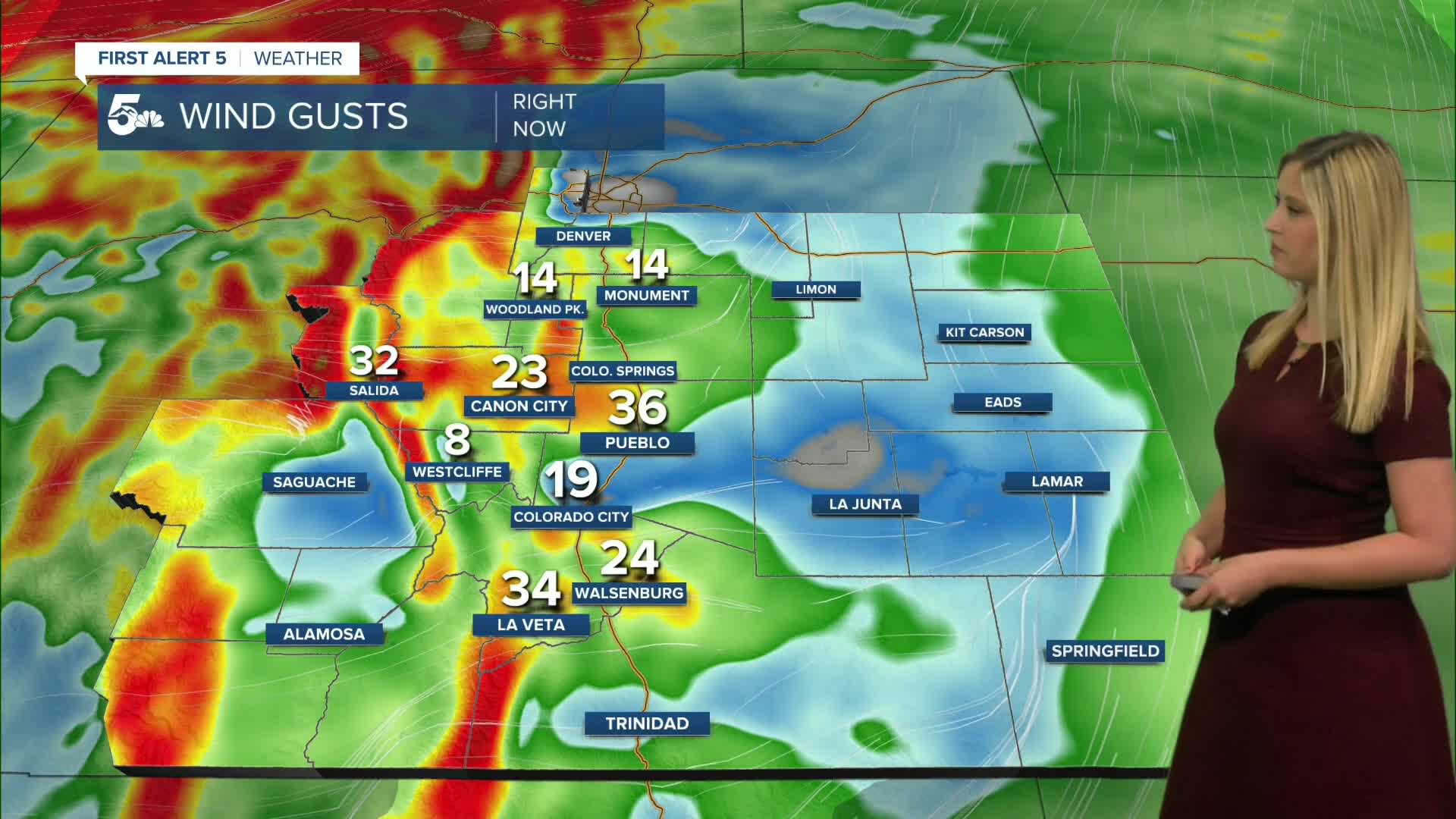
A HIGH WIND WARNING is in effect from 2 am until 9 am for the zones highlighted in gold below. Sustained westerly wind will be between 30-40 mph, gusting up to 75 mph.

Monday will not only be gusty, but it will also be dry. A RED FLAG WARNING has been issued for fire danger and is in effect from 11 am until 6 pm.

Colorado Springs forecast: Low: 47; High: 68;
RED FLAG WARNING from 11 am until 6 pm. WNW wind will be sustained at 10-20 mph, gusting to 35 mph. It will be sunny and dry with temperatures a few degrees above average.
Pueblo forecast: Low: 46; High: 75;
RED FLAG WARNING from 11 am until 6 pm. Winds will be from the WNW at 10-15 mph, gusting to 35 mph. It will be sunny and dry with above-average temperatures.
Canon City forecast: Low: 52; High: 72;
RED FLAG WARNING from 11 am until 6 pm. Winds will be out of the WNW at 10-20 mph, gusting up to 40 mph.
Woodland Park forecast: Low: 43; High: 58;
Cool, sunny and windy on Monday. W wind will be sustained at 10-20 mph, gusting to 40 mph.
Tri-Lakes forecast: Low: 44; High: 62;
RED FLAG WARNING from 11 am until 6 pm. It will be sunny, dry and windy on Monday. WNW wind will be sustained from 15-20 mph, gusting to 40 mph.
Plains forecast: Low: 40s; High: 60s-70s;
RED FLAG WARNING from 11 am until 6 pm for Crowley and Kiowa counties and northward in the plains. Winds will be strong in the afternoon out of the NNW, sustained between 10-20 mph, gusting 30-50 mph.
Walsenburg and Trinidad forecast: Low: 51/51; High: 71/74;
RED FLAG WARNING from 11 am until 6 pm. A HIGH WIND WARNING from 2 am until 9 am for Huerfano County and Raton Pass. In the morning, winds will be strongest out of the W at 30-40 mph, gusting up to 75 mph where the high wind warning is in place. Wind will ease up in the afternoon, but still gust up to 40 mph.
Mountains forecast: Low: 30s-40s; High: 50s-60s;
A HIGH WIND WARNING from 2 am until 9 am for the Southern Sangre De Cristo Mountains and Walsenburg and the Upper Huerfano River Basin. Sustained westerly wind will be between 30-40 mph, gusting up to 75 mph, then will ease up in the afternoon, gusting 30-45 mph. Overall, it will be a dry, cool, and windy day in the mountain valleys.
Extended outlook forecast:
Monday night will be another cold one, dropping below freezing behind a cold front that blows through on Monday afternoon.
Tuesday and Wednesday will be fairly uneventful with 60s and 70s and sunshine. Some changes do come into play on Thursday with our next storm system arriving. This is expected to bring rain to the plains and a wintry mix in the mountain valleys. The sun will return quickly on Friday. Temperatures will cool with this system, but not dramatically.
____
Curious about the First Alert 5 Weather Storm Impact Scale? Check out our cheatsheet explainer.
Watch KOAA News5 on your time, anytime with our free streaming app available for your Roku, FireTV, AppleTV and Android TV. Just search KOAA News5, download and start watching.
