

Today’s Forecast:
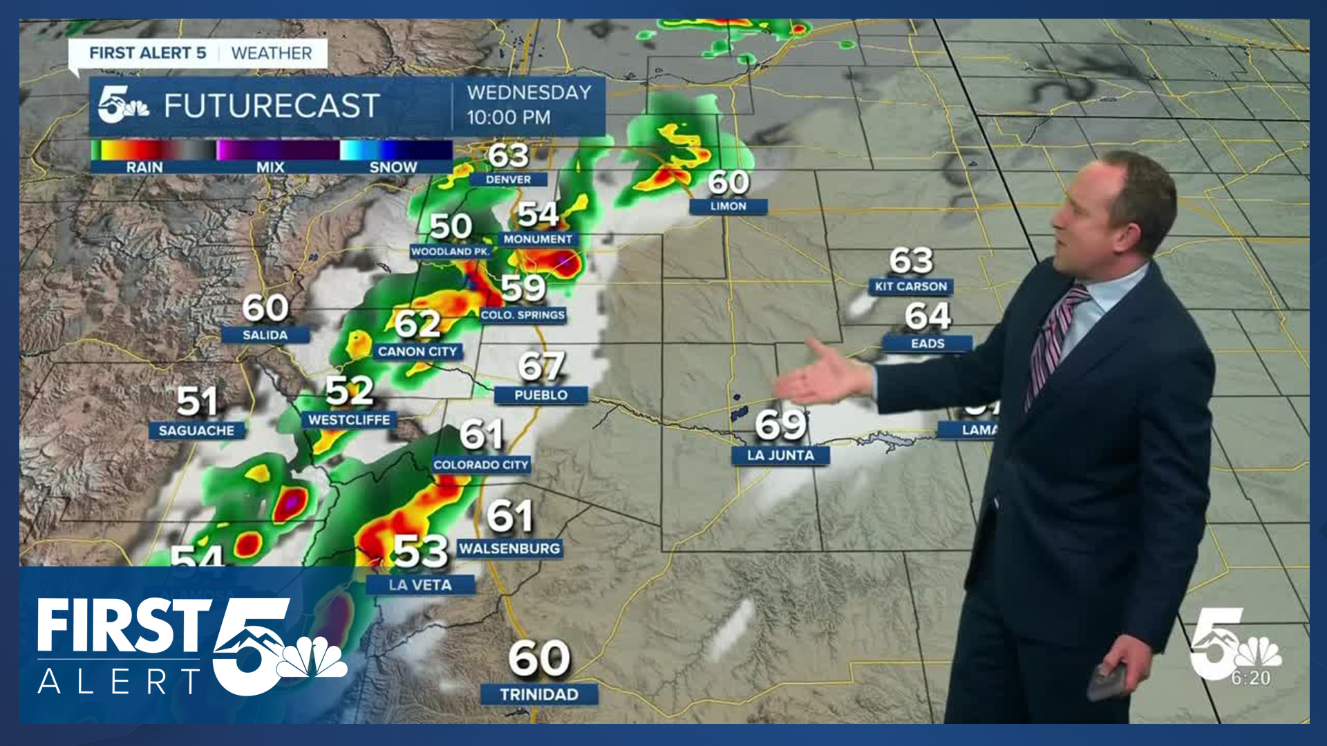
Wednesday will bring a mixed bag of weather, with unsettled conditions on tap for Southern Colorado for the next 12-24 hours. A strong storm centered over the California-Nevada border this morning will lead to a windy day across the state. Wind gusts this afternoon look to range between 30-50 mph, with the strongest gusts south of Highway 50 and over the far eastern Plains. The downslope wind will cause temperatures to spike, warming into the 70s and 80s on the Plains.
Rain will continue to bring a risk of flooding to southwestern Colorado on Wednesday. A line of storms will push east towards I-25 this evening. With increasing instability and wind shear pushing into the state today, some storms will bring a threat of large hail, gusty winds, and even a low end risk of a tornado. The worst of the weather today will continue to be in the southwestern mountains and San Luis Valley.
Colorado Springs forecast: High: 78; Low: 47. Wednesday will be warm and windy in the Pikes Peak Region, with peak gusts up to 35 mph. This evening after sunset, a broken line of storms that moves off of the mountains will bring threats of rain, hail and strong thunderstorm related wind gusts to Colorado Springs.
Pueblo forecast: High: 84; Low: 51. Today will be a windy and very warm day in Pueblo County, with our highs expected to warm well into the 80s. A slight chance of thunderstorms will be possible anytime after 3 pm, with the best chances for rain tonight after sunset.
Canon City forecast: High: 81; Low: 50. A strong low pressure system moving through Nevada this afternoon will bring us a breezy and warm afternoon. Then tonight after sunset, our next front arrives, with a chance for showers and thunderstorms.
Woodland Park forecast: High: 68; Low: 40. Increasing wind during the afternoon hours will be fueled by a strong region of low pressure moving from Nevada into Utah today. Then this evening, a strong cold front will bring the potential for scattered showers and thunderstorms to Teller County.
Tri-Lakes forecast: High: 70s; Low: 40s/50s. Storm energy moving into the state on Wednesday will bring us a mixed bag of weather from gusty winds during the day to a chance of thunderstorms this evening.
Plains forecast: High: 80s; Low: 50s/60s. We're putting fall on pause today, with strong wind gusts to 50 mph in some areas and well above average highs this afternoon. Late this evening, a cold front will bring a chance of thunderstorms to the Plains. Storms should wrap up before daybreak Thursday.
Walsenburg and Trinidad forecast: High: 70s; Low: 40s/50s. Sunny skies and strong winds will make big headlines today, with gusts in some neighborhoods up over 45 mph. Tonight after sunset a cold front will move off of the mountains, with chance for rain and thunderstorms along the southern I-25 corridor.
Mountains forecast: High: 50s/60s; Low: 30s/40s. Windy weather during the day will be followed by the potential for showers and thunderstorms in the mountains late this afternoon and evening. Storms today will be capable of heavy downpours, hail, strong wind gusts, and frequent lightning.
Extended outlook forecast:
Following the passage of tonight's cold front will come a bright, breezy and cooler day on Thursday. Highs on the Plains will warm into the 70s tomorrow, with a mix of 60s and 70s from Friday into Saturday.
As daytime highs cool, so will our overnight lows. Middle to upper 30s can be expected in some neighborhoods Thursday night, with lower to middle 30s both Friday and Saturday nights. In some areas, we could see our first freeze of the season this weekend. Highs will return to the 70s on the Plains from Sunday to Monday ahead of our next cold front Monday evening.
____
Curious about the First Alert 5 Weather Storm Impact Scale? Check out our cheatsheet explainer.
Watch KOAA News5 on your time, anytime with our free streaming app available for your Roku, FireTV, AppleTV and Android TV. Just search KOAA News5, download and start watching.
