

Tonight's Forecast:
The wind will ease up tonight, with a light WSW breeze with gusts of 10-20 mph still expected.
Mountain snow showers will develop overnight along the Sangre De Cristo Mountains, generally above 10,000 feet, as well as the high country west of the Continental Divide.
Tuesday Fire Danger:
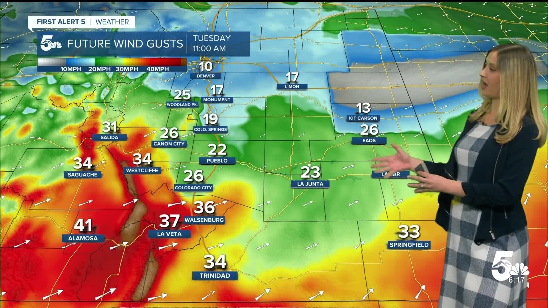
While it will be snowing in the high country on Tuesday, our region will experience downsloping wind that will dry out the air. RED FLAG WARNINGS will be in effect from 11 am until 8 pm on Tuesday for the zones in red. Humidity will drop as low as 9%, and winds will gust up to 45 mph.

Colorado Springs forecast: Low: 39; High: 65;
RED FLAG WARNING from 11 am until 8 pm. Wind will be out of the SW at 10-15 mph, gusting to 35 mph. The sky will be mostly sunny to partly cloudy, and a stray sprinkle is possible as showers move off the mountains.
Pueblo forecast: Low: 41; High: 72;
RED FLAG WARNING from 11 am until 8 pm. It will be sunny, dry, and gusty on Tuesday. Wind will be out of the WSW at 15 mph gusting to 40 mph.
Canon City forecast: Low: 41; High: 67;
It will be partly cloudy on Tuesday with a stray sprinkle possible as showers move off the mountains. It will be gusty with WSW wind at 15 mph gusting to 40 mph.
Woodland Park forecast: Low: 31; High: 54;
It will be partly cloudy with a low chance of a wintry mix during the day. Otherwise, Tuesday will be gusty with SW wind at 15 mph gusting to 35 mph.
Tri-Lakes forecast: Low: 36; High: 60;
It will be partly cloudy on Tuesday and mostly dry, but a brief stray shower may roll off the mountains. Wind will be breezy out of the WSW at 10-15 mph, gusting to 30 mph.
Plains forecast: Low: 40s; High: 70s;
RED FLAG WARNING from 11 am until 8 pm. It will be dry, warm, and gusty on Tuesday. Wind will be out of the WSW at 10-20 mph, gusting to 35-45 mph.
Walsenburg and Trinidad forecast: Low: 41/42; High: 63/68;
RED FLAG WARNING from 11 am until 8 pm. It will be mostly sunny and gusty on Tuesday. Wind will be out of the W at 15-20 mph, gusting 40-45 mph.
Mountains forecast: Low: 30s; High: 50s;
It will be partly cloudy and gusty in the mountain valleys on Tuesday. Wind will be out of the W or WSW at 10-20 mph, gusting 40-45 mph. Snow will be falling over the Sangre De Cristos, the Sawatch Range, and San Juans over about 10,000 feet. A few showers may spill over east of the mountains, into the adjacent plains in the San Luis Valley, Custer County, Fremont County, and Chaffee County.
Extended outlook forecast:
Wednesday's temperatures will be similar to Tuesday's, and the wind will be calmer. It will be a mostly sunny to partly cloudy day.
Thursday warms up 5 degrees or so, and the wind will pick up again. The wildfire danger will rise again on Thursday.
The next cold front arrives on Friday, set to really cool us down with a hard freeze expected Friday night. Some showers may come in with Friday's cold front, favoring the Pikes Peak region. A mix of rain and snow is likely. We will continue to monitor potential impacts, but right now it looks like Teller County and northern El Paso County will see accumulating snow.
____
Curious about the First Alert 5 Weather Storm Impact Scale? Check out our cheatsheet explainer.
Watch KOAA News5 on your time, anytime with our free streaming app available for your Roku, FireTV, AppleTV and Android TV. Just search KOAA News5, download and start watching.
