

Today’s Forecast:
After heavy rain in the Pikes Peaks Region and Southern Colorado on Tuesday, our forecast will remain active from Wednesday until the end of the week. Storms today will be more scattered compared to yesterday. However, where storms do form, heavy downpours, lightning and small hail will remain possible.
Highs today will rebound by as much as 10-15 degrees from yesterday as morning clouds and fog burn off to reveal some sunshine before rain develops this afternoon.
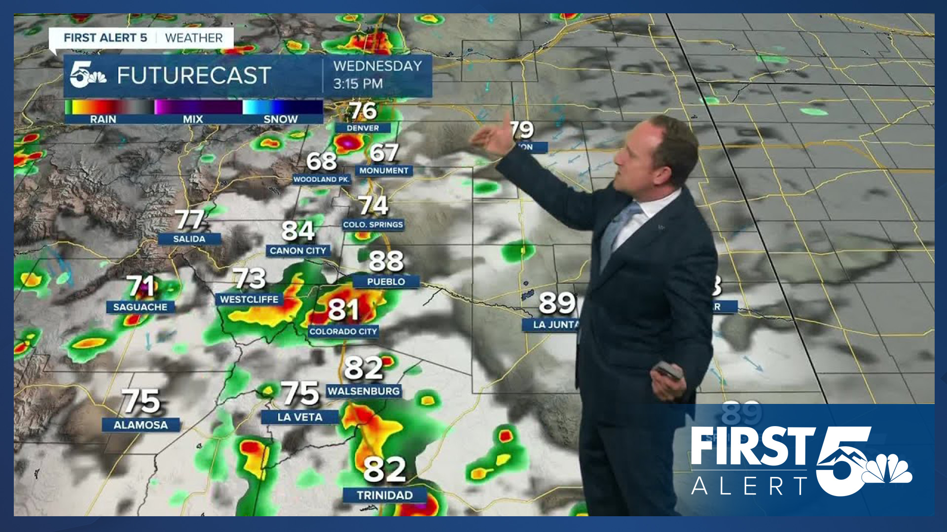
Colorado Springs forecast: High: 79; Low: 54. After a rainy and cool day on Tuesday, today's forecast will be considerably warmer. Areas of fog and mist this morning will give way to another round of showers and thunderstorms this afternoon, with rain wrapping up late this evening.
Pueblo forecast: High: 87; Low: 58. After a high of just 74 degrees back on Tuesday, highs today will rebound into the upper 80s. A mix of sun and clouds during the first half of the day will give way to scattered thunderstorms this afternoon, with rain developing between 2-4 pm.
Canon City forecast: High: 84; Low: 59. Dry, partly cloudy skies this morning will give way to developing rain showers and thunderstorms this afternoon. Storms could once again deliver a big punch, with the potential for heavy rain, flooding, small hail and gusty winds.
Woodland Park forecast: High: 71; Low: 45. As thunderstorms develop by early to mid afternoon, a deep moisture plume will allow for the potential for more big soakers and heavy downpours in Teller County, where the risk for the flooding will remain elevated.
Tri-Lakes forecast: High: 70s; Low: 40s/50s. Highs will be much warmer on Wednesday, with a mix of sun and clouds this morning giving way to scattered showers and thunderstorms during the afternoon and evening hours.
Plains forecast: High: 80s; Low: 50s/60s. The rain that we've seen this week so far has been great news, but if you're looking for drier weather, you're going to have to wait a little longer as scattered showers and thunderstorms will once again be possible on Wednesday.
Walsenburg and Trinidad forecast: High: 70s/80s; Low: 50s. Rain will remain possible this afternoon as additional rain showers and thunderstorms will stick around through at least the start of the holiday weekend.
Mountains forecast: High: 60s; Low: 30s/40s. Like clockwork, rain will begin to develop as early as late this morning, with several rounds of showers and thunderstorms expected through at least sunset tonight. Heavy rain will remain a concern today, and may disrupt outdoor plans today for several hours.
Extended outlook forecast:
The threat for heavy rain and flooding will remain elevated in the Pikes Peak Region and Southern Colorado through the end of the week. Daily highs will warm into the middle 70s in Colorado Springs, which is about 5-8 degrees below average. Highs late this week in Pueblo and Canon City will warm into lower 80s.
Drier air will punch into the state this weekend, but it will take some time for the atmosphere to dry out. A chance for thunderstorms will continue both Saturday and Sunday, with a break from the wet weather by Labor Day.
____
Curious about the First Alert 5 Weather Storm Impact Scale? Check out our cheatsheet explainer.
Watch KOAA News5 on your time, anytime with our free streaming app available for your Roku, FireTV, AppleTV and Android TV. Just search KOAA News5, download and start watching.
