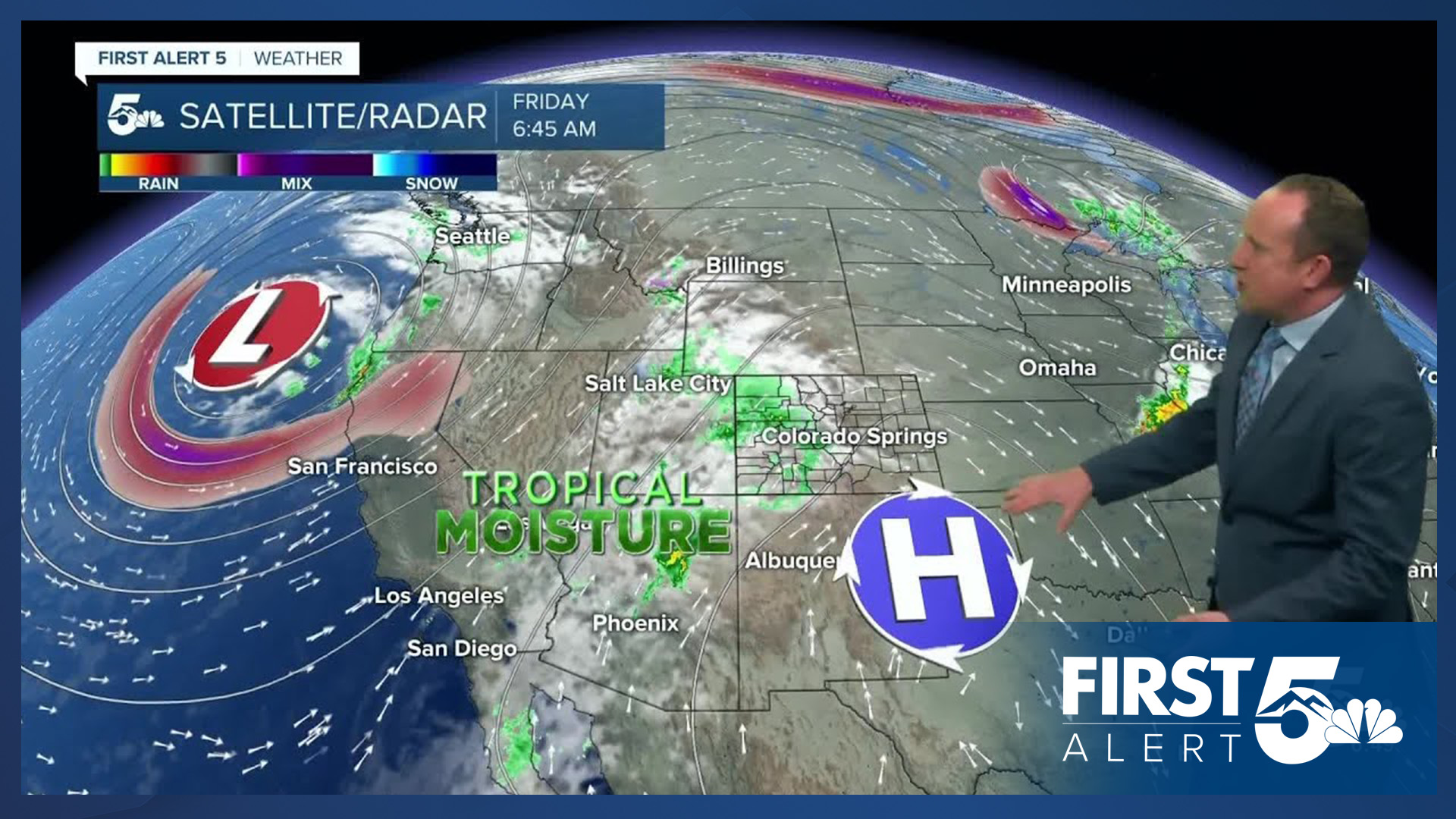


Today’s Forecast:
After we tied the record high temperature in Pueblo yesterday at 89 degrees, today's forecast will be cooler and mostly cloudy. Highs will drop as much as 5-10 degrees due to increasing clouds as sub-tropical moisture streams into the state from our south. Periods of heavy rain will target our mountains and mountain valleys today, mostly along and west of the Continental Divide. Flood Watches have been issued for much of western and southwestern Colorado. These watches will continue through late Saturday evening.

Locally, any rain that moves east towards I-25 and the Plains will quickly dissipate. The best chance for showers will be late this afternoon and evening, and should favor areas near the Pikes Peak Region, especially west of I-25.
Colorado Springs forecast: High: 73; Low: 52. After what could very well have been our last 80 degree day of the year on Thursday, highs today will be as much as 5-10 degrees cooler. Skies will be mostly cloudy and although most of the rain today will fall over the mountains, we could see a few sprinkles or a brief shower this evening.
Pueblo forecast: High: 78; Low: 54. After yesterday's high of 89 that tied the daily record, today's high in the upper 70s will be around 10 degrees cooler. Skies will be mostly cloudy, but rain is not expected.
Canon City forecast: High: 75; Low: 54. Skies will turn mostly cloudy to cloudy on Friday, which should allow for a modest cool down, with highs back down to the 70s this afternoon. While rain will mostly stay to our west on Friday, there will be a slight chance of a shower both today and tomorrow.
Woodland Park forecast: High: 64; Low: 46. Cloudy skies and mild highs on Friday, with a chance for showers this afternoon and evening. Heavy rain is not expected, but keep an umbrella on hand in case you run into some rain.
Tri-Lakes forecast: High: 60s/70s; Low: 40s/50s. Even with as much as 5-10 degrees of cooling from yesterday, highs today will still be above average for this time of the year. Thicker clouds today will not only help with the cooler weather, but could also lead to a shower or two this evening.
Plains forecast: High: 70s/80s; Low: 50s. With partly to mostly cloudy skies and a dry southwest flow in place on the eastern Plains today, we are not expected any rain in eastern Colorado for at least the next 12-24 hours.
Walsenburg and Trinidad forecast: High: 70s; Low: 50s. Skies today will be partly to mostly cloudy, with only around a 10% chance of an afternoon or evening shower. Highs will be cooler than yesterday, topping out in the 70s.
Mountains forecast: High: 40s/50s; Low: 30s/40s. Ongoing threats for rain will impact plans in the high country through the first part of the weekend. While the heaviest rain is expected west of the Continental Divide, rain could be heavy at times by this evening in the Wet Mountains and Sangre de Cristos.
Extended outlook forecast:
Saturday's temperatures will be similar to Friday, with middle 70s in Colorado Springs and lower 80s in Pueblo. Clouds will remain fairly thick throughout the day and after the lunch hour, a line of showers will move from the mountains to the Plains, with a quick chance for rain Saturday afternoon in Southern Colorado.
Sunshine will return Sunday and ahead of a cold front Sunday night, it will be warm and gusty during the day. Highs Sunday will warm into the middle 70s to middle 80s on the Plains. The work week will begin cool and breezy, with Monday's highs in the 50s in Colorado Springs and Tuesday's highs in the 60s, While a chance for showers will be possible on Tuesday, confidence in rain for now remains low outside of the mountains.
____
Curious about the First Alert 5 Weather Storm Impact Scale? Check out our cheatsheet explainer.

Watch KOAA News5 on your time, anytime with our free streaming app available for your Roku, FireTV, AppleTV and Android TV. Just search KOAA News5, download and start watching.
