


Tonight's Forecast:
The wind has already weakened significantly this evening, and will continue to do so over the Plains as pressure gradients relax behind a departing storm. Mountain areas will stay windy at times, with 25-35 mph gusts possible across the higher elevations. Temperatures tonight will cool down to the 10s and 20s, with the San Luis Valley and mountains dropping down to the single digits.
COLORADO SPRINGS: Low: 20; High: 46. Light winds, mostly sunny skies and just above average highs will make for a nice Sunday across the Pikes Peak Region. Enjoy!
PUEBLO: Low: 17; High: 49. Bundle up early in the morning as we'll start out the day in the teens. Afternoon highs will be seasonably mild for this time of the year, topping out near 50 degrees.
CANON CITY: Low: 27; High: 52. Sunday will be mostly sunny, mild and breezy to gusty at times. Highs will top out in the lower 50s.
WOODLAND PARK: Low: 15; High: 40. It will remain windy at times on Sunday across Teller County, with afternoon peak wind gusts up to 35 mph.
TRI-LAKES: Low: 10s/20s; High: 40s. Sunday's forecast will be mostly sunny and pleasant, with highs topping out in the lower to middle 40s.
PLAINS: Low: 20s; High: 40s. Not as windy on Sunday, and mostly sunny across the Plains. High temperatures will warm into the 40s.
WALSENBURG/TRINIDAD: Low: 20s; High: 40s/50s. Dry skies will continue on Sunday and westerly winds will be pretty gusty at times, especially around Walsenburg.
MOUNTAINS: Low: 0s/10s; High: 20s/30s. Dry and windy during the day across the mountains of Southern Colorado, with increasing chances for snow heading into Sunday evening.
Extended Outlook:
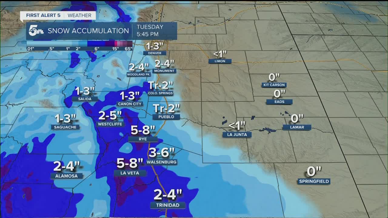
Mountain snow is likely from late Sunday night, and could continue at times through Tuesday afternoon. East of the mountains, snow chances will increase Monday evening and continue into Tuesday morning. A few inches of snow will be possible across the I-25 corridor, but it's a little too soon to pinpoint exact totals region-by-region. This storm will also bring in a colder airmass early next week, with warming highs as the storm departs Wednesday and Thursday.
