

Tonight's Forecast:
Overnight, into early Wednesday morning, it will be partly cloudy with widely scattered light rain showers possible across the region. Temperatures will be above average overnight by 10-15 degrees.
Colorado Springs forecast: Low: 46; High: 77;
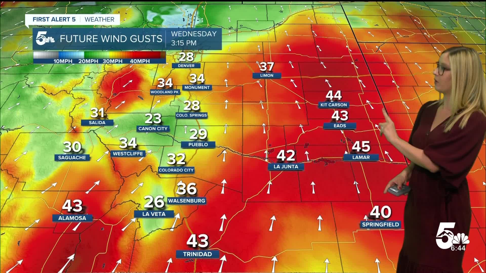
Wednesday will be the warmest day of the week, over 10 degrees above average. Wind will be gusty, out of the SSE at 10-15 mph, with gusts reaching 35 mph. There is a chance of a spotty afternoon rain shower or thunderstorm.
Pueblo forecast: Low: 50; High: 84;
Very warm on Wednesday with partly cloudy conditions. Wind will be out of the S at 10-15 mph, gusting to 35 mph. There is a chance of an evening shower or thunderstorm.
Canon City forecast: Low: 51; High: 79;
Partly cloudy on Wednesday with a low chance of a sprinkle in the morning, and a better chance of rain in the evening. In between, it will be warm and breezy with SW wind at 5-10 mph gusting to 25 mph.
Woodland Park forecast: Low: 41; High: 67;
It will be partly cloudy with a chance of rain and isolated thunderstorms in the late afternoon and evening. Wind will be out of the S at 10-15 mph, gusting to 30 mph.
Tri-Lakes forecast: Low: 46; High: 73;
It will be partly cloudy on Wednesday with mild temperatures and breezy wind out of the SSW at 5-15 mph, gusting to 30 mph.
Plains forecast: Low: 50s; High: 70s-80s;
The plains will be partly cloudy with a low chance of rain in the early morning. Overall, it will be a warm and windy day with S wind at 10-20 mph gusting 30-45 mph.
Walsenburg and Trinidad forecast: Low: 51/54; High: 76/75;
It will be partly cloudy with a low chance of rain in the morning and again in the evening. The afternoon will be warm and windy with S wind at 15-20 mph gusting 30-40 mph.
Mountains forecast: Low: 30s-40s; High: 60s-70s;
It will be partly cloudy with a few rain showers in the San Luis Valley in the morning, with scattered rain and thunderstorms possible for all of our mountain zones in the evening. The daytime will be mild and breezy with SW wind at 10-15 mph gusting 20-30 mph.
Extended outlook forecast:
Thursday will be less windy and a bit cooler, to the 60s and 70s with partly cloudy conditions. There is a low chance of a morning rain shower, but the day will be dry for the most part. Wind will be out of the SSW at 10 mph, gusting to 15 mph.
Friday and Saturday will be cooler in the 50s to 60s with lots of sunshine. Sunday warms back to the 60s, and 70s with sunny conditions prevailing. Temperatures overnight will fall to the mid-30s this weekend in the plains.
____
Curious about the First Alert 5 Weather Storm Impact Scale? Check out our cheatsheet explainer.
Watch KOAA News5 on your time, anytime with our free streaming app available for your Roku, FireTV, AppleTV and Android TV. Just search KOAA News5, download and start watching.
