

Today’s Forecast:
An upper-level ridge of high pressure is on the move east today, as a Pacific weather system swings through Southern California and Arizona as we move through the day. We call this set up the "warm before the storm" as our airflow shifts southwesterly between the departing high, and incoming low. At the same time, a backdoor cold front will try to move in from the northeast. While it will struggle to make it fully into the Pikes Peak Region, it will shift winds back to a southeasterly direction by mid to late afternoon.
We'll see a few mountain wave clouds streaming in from the southern mountains early in the morning with clearing skies by late morning. We'll see mainly sunny skies through the afternoon, with clouds returning in the evening as our storm system approaches. Highs today will be in the low to mid 60s depending on your elevation, which is about 10 degrees above average.
Colorado Springs forecast: High: 62; Low: 34. Temperatures will rebound into the lower 60s on Wednesday as we await our well advertised storm that will bring significant changes to the Pikes Peak Region late this week.
Pueblo forecast: High: 67; Low: 32. Today's high in the upper 60s will be around 10-12 degrees above average for this time of the year. With increasing chances for rain late this week, highs will drop down to the 50s Thursday and Friday.
Canon City forecast: High: 64; Low: 37. Partly cloudy skies and light W/SW winds will bring a beautiful Wednesday to eastern Fremont County, with today's highs climbing into the lower to middle 60s.
Woodland Park forecast: High: 53; Low: 27. Today's weather will be quiet and mild, with light southwest winds and partly cloudy skies.
Tri-Lakes forecast: High: 50s/60s; Low: 30s. Wednesday's forecast will feature light winds, and a mild mix of sun and clouds. Highs today will climb into the upper 50s and lower 60s.
Plains forecast: High: 60s; Low: 30s. Dry skies and mild highs on Wednesday will give way to rain on Thursday and a much cooler forecast late this week. A few spots today could approach the 70s.
Walsenburg and Trinidad forecast: High: 60s; Low: 30s. Partly to mostly cloudy skies on Wednesday, with above average highs this afternoon in the 60s for the southern I-25 corridor.
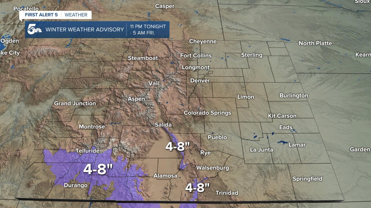
Mountains forecast: High: 30s/40s; Low: 20s/30s. While we could see a few light snow showers today, mainly in the San Juan Mountains, Wednesday's forecast should be a classic case of the "calm before the storm". Snow will increase in the Sangres overnight tonight, with a Winter Weather Advisory in effect on Thursday.
Extended outlook forecast:
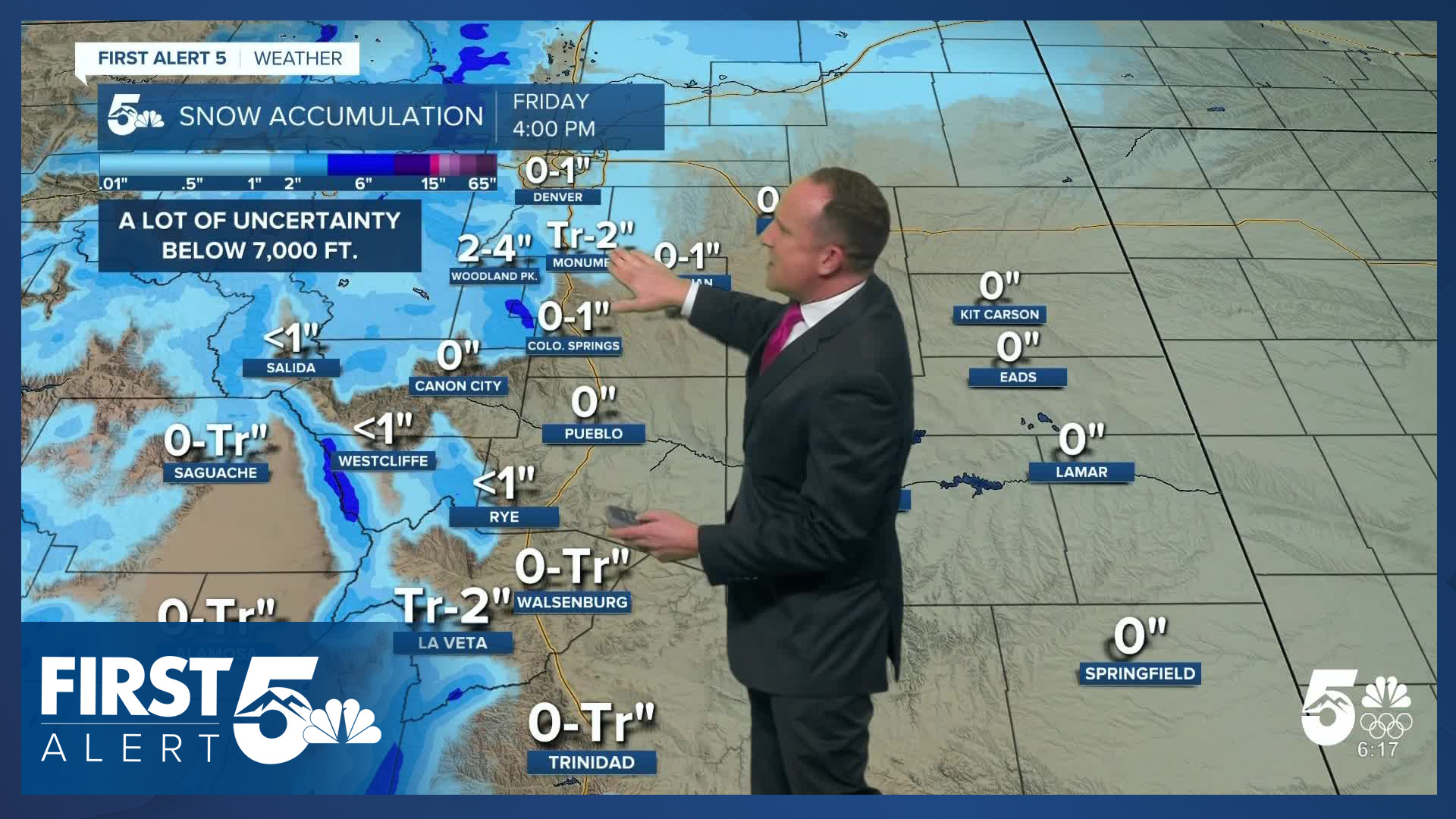
Our well-advertised storm system will arrive Thursday. Rain chances increase through the day - with low chances in the morning, moderate chances by afternoon, and widespread rain by the evening. We'll see morning showers Thursday on the southeastern plains, and scattered snow showers in the morning in the mountains. The snow level with this system stays relatively high due to a lack of cold air - around 7,000-8,000 feet. That line may briefly dip down closer to 6,000-6,500 feet early Friday morning. Showers continue overnight into Friday morning. Travel impacts are likely for the Friday morning commute over the Palmer Divide, and in Teller County, where precipitation will change over to snow.

We're also likely to see low clouds and fog on Friday morning. Showers will wrap up by Friday afternoon as our wind direction swings from upslope, to a northerly flow. Skies will steadily clear heading into the evening.
Saturday returns to calm and relatively clear weather with highs in the 50s. Another Pacific storm system is likely to impact Southern Colorado by Sunday. While there are details to work out with track and timing, the system will bring more unsettled weather: rain and snow showers Sunday night into Monday. Behind that system, Thanksgiving week looks chilly as cold air moves in as a consequence of a disruption to the polar vortex. A cold front passes by on Tuesday - with highs trending into the upper 30s to low 40s in the second half of next week.
____
Curious about the First Alert 5 Weather Storm Impact Scale? Check out our cheatsheet explainer.
Watch KOAA News5 on your time, anytime with our free streaming app available for your Roku, FireTV, AppleTV and Android TV. Just search KOAA News5, download and start watching.
