



Tonight's Forecast:
An Air Quality Alert remains in effect until at least 9 a.m. on Wednesday due to wildfire smoke. It is advised to reduce your time outdoors, especially for sensitive groups.

Weather conditions overnight will be partly cloudy and mild. Wind will be light.
Wednesday Flash Flood Risk:
A FLASH FLOOD WATCH has been issued in the vicinity of the Aspen Acres Fire from noon until 8 p.m. on Wednesday.
- Watch an explainer of why the vicinity of the Aspen Acres Fire has a flash flood risk below:
The risk of dangerous flash flooding and debris flow will be high with even a small amount of rainfall.

Colorado Springs forecast: Low: 59; High: 89;
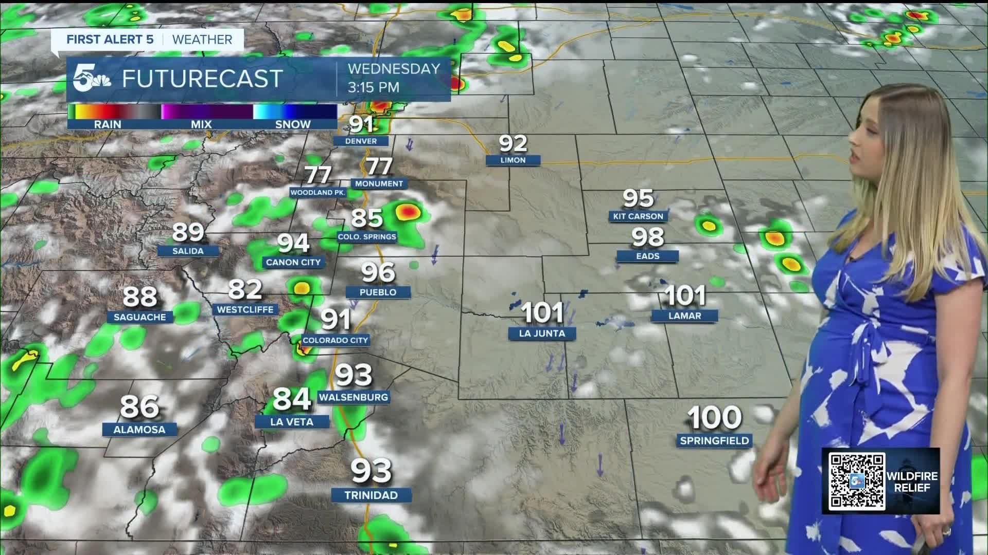
Wednesday will be partly cloudy with a chance of showers and thunderstorms in the afternoon. Wind will be out of the N at 5-10 mph, gusting to 20 mph. Some of the wildfire smoke will clear out due to showers and the wind shift.
Pueblo forecast: Low: 63; High: 98;
A FLASH FLOOD WATCH is in place for the Aspen Acres Fire zone from noon until 8 pm. For the city of Pueblo, it will be partly cloudy on Wednesday with spotty afternoon showers and thunderstorms. Wind will be out of the N at 5-10 mph gusting to 25 mph.
Canon City forecast: Low: 63; High: 95;
It will be partly cloudy with a hazy sky on Wednesday due to wildfire smoke. There is a chance of showers and thunderstorms in the afternoon. Wind will be out of the NNW at 5-10 mph gusting to 25 mph.
Woodland Park forecast: Low: 54; High: 83;
It will be partly cloudy on Wednesday with N wind at 5-10 mph gusting to 20 mph. Showers and thunderstorms are possible in the afternoon.
Tri-Lakes forecast: Low: 57; High: 86;
Wednesday will be partly cloudy with a chance of thunderstorms in the afternoon. Wind will be out of the NNW at 5-10 mph gusting to 25 mph.
Plains forecast: Low: 50s-60s; High: 90s-100s;
Another hot day with mostly sunny to partly cloudy conditions. In the afternoon and evening, spotty thunderstorms are possible. Wind will generally be out of the N at 5-10 mph gusting 20-30 mph.
Walsenburg and Trinidad forecast: Low: 64/60; High: 93/95;
It will be partly cloudy and hazy early on, with spotty thunderstorms forming in the afternoon. Wind will be out of the NNE at 5-10 mph gusting to 20 mph.
Mountains forecast: Low: 40s-50s; High: 80s-90s;
The mountain valleys remain hazy from wildfire smoke. It will be a hot day with spotty early afternoon thunderstorms.
Extended outlook forecast:
Thunderstorms will once again be possible on Thursday, forming in the mountains then spreading east into the plains. A few more spotty storms are possible on Friday. Temperatures will be near average for the last 2 days of the workweek.
Then this weekend becomes sunny and hot. Temperatures will be in the 80s-100s across the region and the sun will be out in full force.
____
Curious about the First Alert 5 Weather Storm Impact Scale? Check out our cheatsheet explainer.
Watch KOAA News5 on your time, anytime with our free streaming app available for your Roku, FireTV, AppleTV and Android TV. Just search KOAA News5, download and start watching.
