


Sunsets are past 8 PM and temperatures are getting warmer. So maybe you're planning to hike this weekend. If so, let's check out your weekend hiking forecast.
First, for those of you who are already hiking at high elevations, here's how conditions looked yesterday on Mount Elbert. Our snowpack is in the eighth percentile for this time of year. But there's still deep snow above 11,000 feet, including patchy deep in the trees.

This snow gets soft within a couple of hours of sunrise. So if you do want to hike up high, you should start your hike very early to avoid post-holing (e.g. slushy snow that won't support your weight).
The height in the sky where the air hits freezing (the freezing level) will jump up Friday and Saturday and drop Sunday. The best freezes will be Thursday night, Friday night, and Sunday night. Meaning above treeline hiking conditions will be best Friday morning, Saturday morning, and Monday morning.
Dry avalanches are a concern in the northern mountains where plenty of new snow fell recently. Wet avalanches are an issue Friday and Saturday afternoons on slopes greater than 30-35 degrees with sufficient snow depth and can be avoided by starting and ending your hike early. If you’re skiing, you’ll mainly encounter sun crusts that soften a bit - you’re not going to be in powder city.
Popular hikes in Cheyenne Cañon, Pike National Forest, the Wet Mountains, and the Ramparts will be great to hit this weekend. Trails should be dry with summer conditions. Friday and Saturday look particularly good; Sunday has chances for afternoon mountain storms.

Let's talk gear. Below treeline, you'll want two layers, hiking boots, and may want trail gaiters because streams are running high due to snowmelt. You should pack insect repellent, sunscreen, and a sun hat as well.
Above treeline, you still need trail crampons, three layers—base, insulating mid, and wind shell, gloves, and for any deep snow, snowshoes. Either way, remember sunglasses, sunscreen, water, and food.

Now to the forecast. For high elevations, let's use Quandary Peak. Friday starts in the 20s at the base.
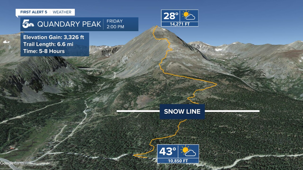
Temps bump to the 40s in the afternoon. Below freezing all day up top.

Saturday's temps are a bit warmer. Post-holing is likely by late morning. Isolated thundershowers in the PM.


Sunday starts a bit cooler. Afternoon thundersnow is likely.

At low elevations, let's look at Mount Muscoco in N. Cheyenne Canon.

Temperatures Friday afternoon range from the 50s to 60s.

On Saturday they start in the 40s and climb to the 50s with a late PM storm chance.

On Sunday, temps start in the low 30s with some fog, climbing to the 40s, windy in the afternoon with another weak shower chance.
____
Have a question or story idea you would like the First Alert 5 Weather team to consider? Email: weather@koaa.com
Watch KOAA News5 on your time, anytime with our free streaming app available for your Roku, FireTV, AppleTV and Android TV. Just search KOAA News5, download and start watching.
