


Colorado's 14ers are one of our biggest summer activities for Colorado residents and visitors alike.
According to the Colorado 14ers Initiative, 260 thousand people hiked one of our 58 tallest peaks in 2023, the most recent year data is available, and that was - low - compared to prior years. If you're someone using the unofficial start of summer to hit the trails, you should still be prepared for winter conditions.

Snowpack is well below average. The Colorado Avalanche Information Center (CAIC) tells me that the snow level is currently sitting at approximately 11,500 feet statewide. It's slightly higher in the southern mountains and slightly lower in the northern mountains.
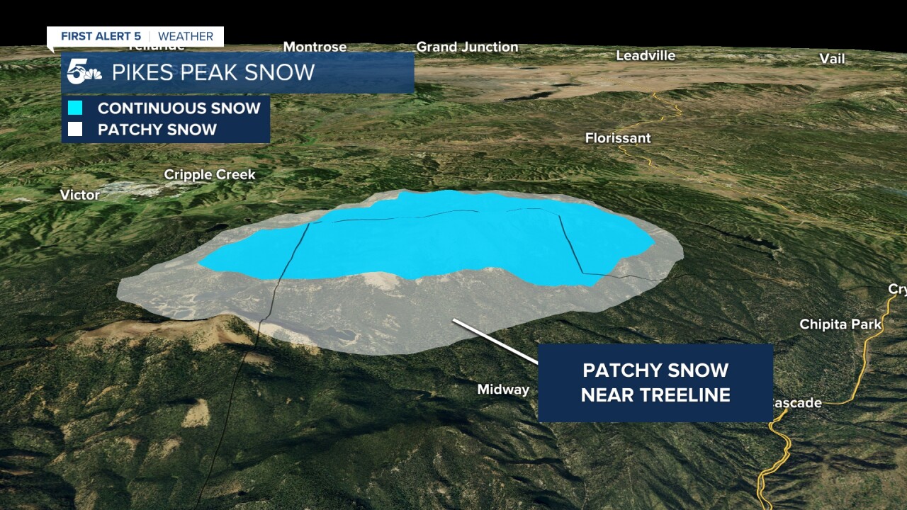
But the snowpack changes a lot depending on which side of the mountain you want to climb. Let's use Pikes Peak as an example. You'll find patchy snow near treeline.

Snow increases above treeline, mostly on west, north, and east facing slopes. You'll find bare patches above treeline on southern slopes and exposed ridgelines.

But some routes are already snow free - generally routes that follow a prominent, exposed ridge with patchy tree cover at lower elevations facing east.
For example, the standard route up Mount Shavano, a peak in our central mountains, is mostly snow free at this point.

But the connecting saddle to Tabeguache still holds patchy deep snow.

Despite the below-average snowpack, you need to be avalanche aware. The CAIC previously had above treeline zones Saturday at a moderate 2-out-of-5 risk. This has been downgraded now to a 1-out-of-5 low risk. However, there remains some level of elevated risk near the snow line where the snow is thin, and in rocky steep areas. This risk is greatest above and near treeline, particularly on northerly facing slopes, and the concern is for wet slab and loose wet avalanches.

But gullies and shaded slopes are also at higher risk. This photo shows a loose wet avalanche on Crestone Peak that occurred on a south-facing gully on the peak's standard route on Thursday. This is the typical ascent route for this peak. Which goes to show - while general avalanche risk is low, steep slopes at very high elevations can still avalanche.

Wet slab and loose wet avalanches occur due to poor freezes leading to water running through the snowpack. You can avoid these risks by starting and ending 14er hikes early. If you start falling through the snow and it won't hold your weight on a steep slope, that's a sign that it is not safe.

For gear this weekend, you should bring snowshoes and spikes for your feet, and a dual-layer system with a breathable base and an insulating mid-layer.
Have fun, and stay safe!
____
Have a question or story idea you would like the First Alert 5 Weather team to consider? Email: weather@koaa.com
Watch KOAA News5 on your time, anytime with our free streaming app available for your Roku, FireTV, AppleTV and Android TV. Just search KOAA News5, download and start watching.
