


The biggest snowstorm of the season for some of us is headed to Colorado from Wednesday to Friday. If you're on social media often, you may have seen a snow map like this circulating around:
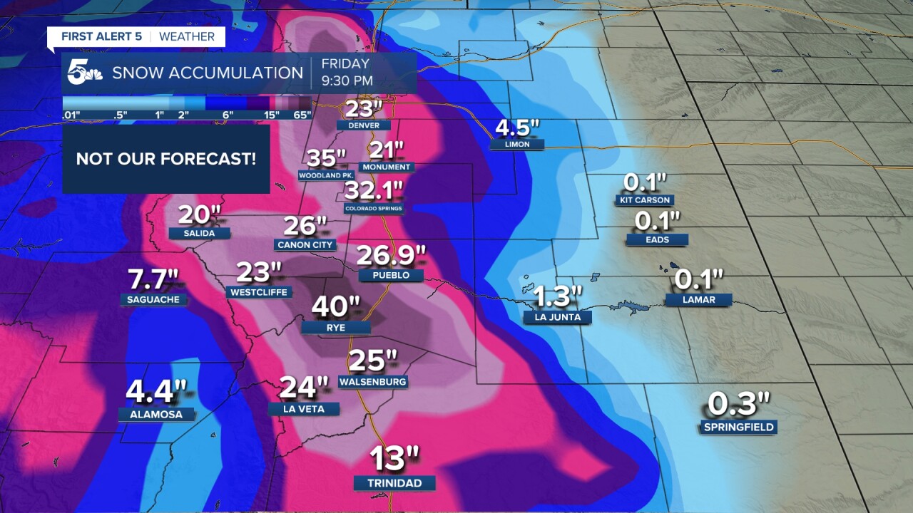
Without our graphics of course - just those numbers and that map. Snowmageddon! That was the "evening run" of the GFS that ran Sunday night - March 9th. The GFS is one of our forecast models, on-air we'll often call it the "American Model" because it's run by the National Weather Service here in the United States. But we did NOT show you that map - because that isn't what's going to happen. This is a big difference in what our meteorology team does, versus an app or social media - both of which may look at one model, or a couple, and show a model total as fact. So let's look at how we forecast.
Here's the GFS again - this is actually the model - with the grid points colored blue.

The GFS runs all around the world - it's a lot of space! Every 8 miles, it has a grid point along the ground. It also has these grid points at different points in the sky - stacked above it, over 100. Think about how many points that is across the whole planet! But the model doesn't have a point everywhere...it can't. It starts by taking in measurements. From surface weather measurement sites, from airplanes, from radar, and from weather balloons the National Weather Service launches. Models run very complicated physics, chemistry, and mathematical equations to model how what's happening now, will evolve in the future. Even with powerful supercomputers, we don't have the computing power - the GFS runs every 6 hours out to 16 days in the future. So, models have to estimate between the points. If it's 72 here and 68 there, it's probably 70 in between.
That's not how the atmosphere works. Take Pikes Peak for example. It's big. But, on the GFS, it's a single grid point, and the entire range is a handful. That creates error - estimates can be wrong. As the model goes out in time...the errors get bigger.

On our end, a week out we're telling you general thoughts on a system. We know we're getting a storm, but things like the track and totals - we don't dive into. They're going to change. If you see snow totals on social media for a storm a week out: ignore it. It's not going to be accurate - ever.
Once we get within 2-3 days of a storm, we can look at higher resolution models. Check out this one:

That model has a grid point every TWO miles. That means better accuracy. That's when we can figure out if we might see, say thundersnow.
The storm has also often formed, or is onshore, by this point, so we're also looking at live observations of it and comparing them against what the models had been thinking to get a sense of which one (or ones) are handling it the best.

We use that data to give you a snowfall map, rain and snow lines, and timing. Throughout this process we're also tweaking our forecast based on our knowledge. Every day, we adjust temperatures and other variables in your 7 day forecasts based on applying our own scientific knowledge, to the data and models we look at.
Within a day - we get really fine tuned. The storm has formed, we're looking at radar and other real time data to pinpoint exactly who gets what, where, and hyper-specific impacts.

None of this is stuff a weather app will tell you, nor will a model snow map on your favorite social media app. Point is - when a major storm is approaching, choose trusted weather sources. No one gets it right all the time - we are predicting the future - but we won't hype up a forecast.
____
Have a question or story idea you would like the First Alert 5 Weather team to consider? Email: weather@koaa.com
Watch KOAA News5 on your time, anytime with our free streaming app available for your Roku, FireTV, AppleTV and Android TV. Just search KOAA News5, download and start watching.
