


After a week of bitter cold on the Plains and heavy snow in the mountains, we have seen a notable improvement to our state's snowpack.
Last week at this time on January 10, 2024, our state's snowpack was at 70%.
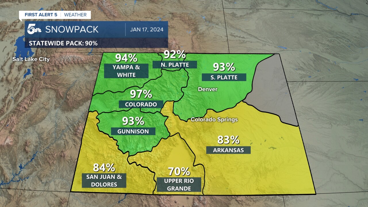
This week, that number has improved to 90%.
Areas in green (see image below) are now reporting snowpack at 90-100%. These basins are in the state's central and northern mountain ranges.
Southern mountain ranges also saw a boost, but didn't quite squeeze out moisture as effectively during this last storm cycle.
An important basin for Southern Colorado residents, the Arkansas River Basin, is now up to 83%.
It's not just good news for our state's snowpack, the recent storm cycle also delivering the goods to our state's ski areas and ski resorts.
Snow being measured in feet in the high country this past week, with great mid-January conditions for skiers and boarders.

And more snow is on the way this week, with another storm expected to hit the Rockies through Thursday evening.
In response to the incoming storm, the National Weather Service has issued a Winter Storm Warning for the Flat Tops, Gore Range, Elk Range and the Front Range, in effect until 5 pm Thursday. Amounts of 10-20" of snow and gusts to 60 mph can be expected in the warned area. Travels to the high country should expect hazardous driving conditions.
Winter Weather Advisories have been issued for areas farther to the south, and includes the Mosquito and Sawatch Ranges. Snow accumulations of 6-12" will be possible, with wind gusts to 70 mph. Widespread blowing snow in these areas could pose significant impacts to travel.

The downside and dangerous side to all of this snow — high avalanche danger.
An Avalanche Warning remains in effect until at least 5 pm Wednesday for the Sawatch and Elk Ranges.
An Warning remains also remains in effect until at least 5 pm Thursday for the Park Range, Flat Tops, Gore Range Front Range and Summit County.
According to the Colorado Avalanche Information Center, there's a level 4 out of 5 risk of large avalanches in these areas.
This warns of strong avalanche potential. Back country skiers and boarders should resist the urge to ride in these areas until the warning has expired, even beyond.
The same would apply to outdoor recreation in these areas.

