


COLORADO (KOAA) — Colorado's snowpack is once again setting records, in the wrong direction.

After recording the warmest winter on record in Colorado Springs — and statewide — March has begun the same way: warm, and dry. February is historically the snowiest month in Colorado's mountains, with March a close second according to data from the USDA. March is the snowiest month of the year on average across portions of the Front Range — Colorado Springs and areas north in particular.
This means we need several significant snowstorms just to keep pace with the climbing average.
Today, Colorado has 8.1" of liquid water contained in the snow (SWE), which is 0.2" below the previous SNOTEL-era record low of 8.3" set in 2002.
Keep in mind SNOTEL data records go back to 1987. Before that system became the standard we did have two years where snowpack appears to be even worse in early March than it is today. First in 1977, and again in 1981. Nonetheless, the current snowpack is in poor shape.

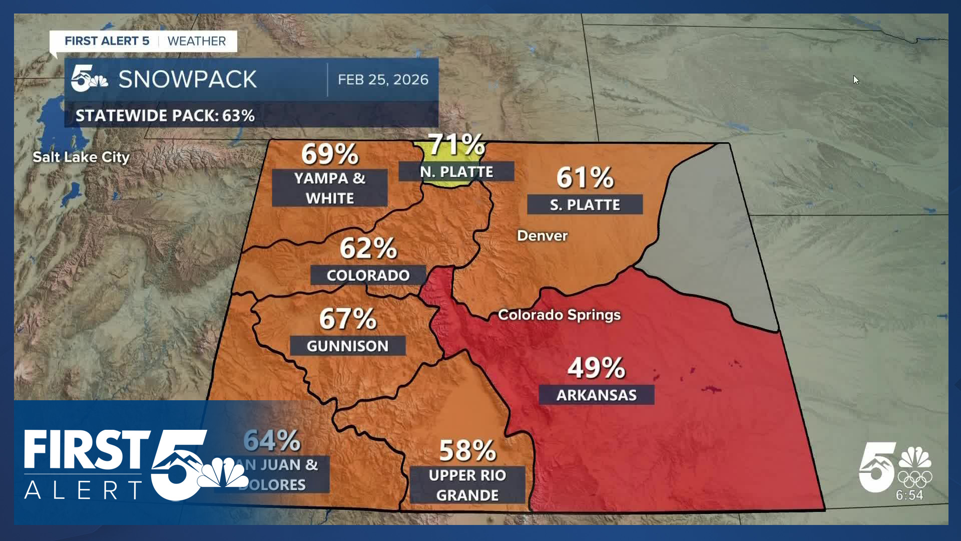
Last week's map had shown some signs of improvement. Most basins statewide were somewhere in the 60% range. The Arkansas Basin — which is the local basin for southern Colorado — stands out at only 49% of average.

This week, we've seen little change in the northern mountains. The snow we have seen in the last 7 days has largely been concentrated in those areas. In the southern tier we've seen declines — relative to average. Particularly in the San Juan, Upper Rio Grande, and Arkansas basins.
In the northern half of the state, these decreases represent a relative lack of new snow, not a drop in what's already on the mountains for the most part. In the southern basins — the actual SWE itself has declined in the past week.
Within the Arkansas basin specifically, not only is the basin at record low levels — the highest observed snowfall in the SNOTEL-era of observations between today, and average peak snowpack, would not be enough to bring the basin to average. In fact, it wouldn't be close. This would represent a best case scenario — as bad is better than "historically bad".

However, the latest climate prediction center outlook favors below average precipitation over the next 3 months in southern Colorado. The outlook also tilts toward above average temperatures.
We are in a bad spot.
We will get snow this weekend, particularly in the northern half of the state. But, it won't be enough to bring us out of record-low territory.
____
Have a question or story idea you would like the First Alert 5 Weather team to consider? Email: weather@koaa.com
Watch KOAA News5 on your time, anytime with our free streaming app available for your Roku, FireTV, AppleTV and Android TV. Just search KOAA News5, download and start watching.
