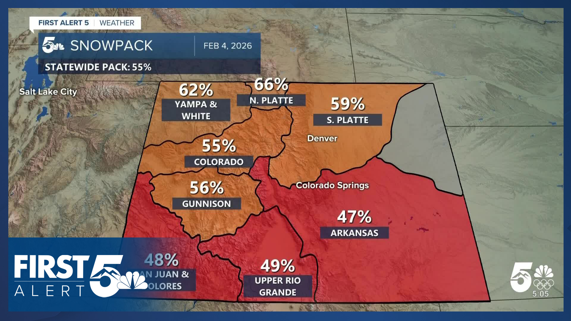


COLORADO (KOAA) — Colorado's snowpack situation continues to worsen despite recent snowfall, with statewide levels dropping from 57% of average last week to 55% of average today.

While snowpack has technically risen from last week - with 5.4" of snow-water equivalent (SWE) versus 5.3" last week, the record low mark moved from 5.9" to 6.2" in the same time span. The average has climbed from 9.1" to 9.8", so by any metric, snowpack has fallen further behind.

The Arkansas Basin is even worse - at just 47% of its average snowpack. While not a record low for the region, this places the basin in the 3rd percentile for snowpack, meaning 97 out of 100 years would on average have more snow.
Statewide conditions remain dire across Colorado's major basins. The North Platte Basin shows the best performance among all regions but still registers at 66% of average snowpack levels.

A persistent ridge of high pressure over the western United States has dominated weather patterns this winter, keeping storm systems away while maintaining unusually warm temperatures across the region. La Niña conditions in the Pacific Ocean are partly responsible, but the upper ridge has been further east than usual as well. That's partly been driven by a persistently "positive" PNA - the Pacific North American Oscillation. The combination of the northerly jet stream changes from La Niña plus the positive PNA - and a couple of other patterns - are why it has been so dry.
PATTERN CHANGE POTENTIAL
The Pacific North American Oscillation is modeled by most of our best performing model guidance to flip negative within the next two weeks.


This shift typically moves low pressure systems into the western United States, creating conditions more favorable for snowfall compared to the current actively unfavorable pattern. This doesn't guarantee snow, but it is a good signal for long-term forecasting.
Additionally, La Niña conditions in the Pacific Ocean are weakening as the region moves toward neutral conditions. While the latest update on the El Niño-Southern Oscillation (ENSO) places the most important forecasting-use measurement area (known as "3.4") within the range that qualifies as La Niña, other data shows the cool water is not deep in the basin - and changes in wind patterns in the low atmosphere above this part of the Pacific. In essence, the conditions suggest a trend toward neutral in the coming month or two. This transition typically alters jet stream patterns, allowing Colorado to experience more frequent and nearer-to-average storm systems.
In the shorter term, the latest Climate Prediction Center forecasts show above-average precipitation for mid-February across the region - which partly reflects the PNA shift.
While these changes won't restore snowpack levels to average, they represent a crucial shift away from the persistently dry conditions that have dominated this winter season.
____
Have a question or story idea you would like the First Alert 5 Weather team to consider? Email: weather@koaa.com
Watch KOAA News5 on your time, anytime with our free streaming app available for your Roku, FireTV, AppleTV and Android TV. Just search KOAA News5, download and start watching.
