


One of the most intense windstorms in southern Colorado history roared through almost four years ago to the day of our current wind event. December 15, 2021 is a day longtime residents likely remember well, and there are similarities to today's setup.
If you arrived in Colorado that morning not knowing where you were, you might have thought you'd entered a hurricane. In the morning, wind gusts above 100 mph were recorded in the Pikes Peak region and across the Front Range. The howling winds were sustained over several hours.
Trees a century old were toppled, and major power outages occurred. Colorado Springs Utilities reported 248 downed wires, and 33 transformers and 5 transmission poles sustained damage. Forty-seven thousand CSU customers lost power, along with 9,000 in Huerfano and Las Animas counties. Power restoration took days for hundreds of residents.

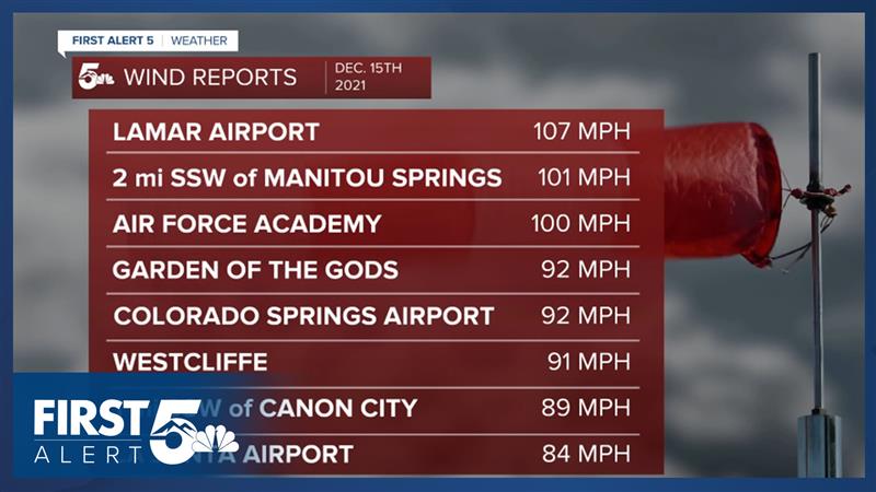
A large swath of Interstate 25 reported damaging wind gusts. Lamar's airport gusted to 107 miles per hour at 8:44 a.m. Colorado Springs' airport reported its second strongest wind gusts ever at 92 miles per hour. A large swath of the upper Arkansas River valleys saw gusts well above hurricane force.
Winds that strong created a headache on the roads. The storm toppled many trucks and trailers, at one point closing Interstate 25. The storm produced widespread power outages, toppled many trucks and trailers, and caused significant property damage as tree branches fell onto people's cars and homes.
WHEN IS IT UNSAFE TO DRIVE IN STRONG WINDS:
High profile trucks are most at risk of tipping over in high winds - and any high profile vehicle such as an SUV can become hard to control when winds exceed a certain threshold.
I investigated various sources: there's no specific wind speed at which every vehicle will tip over. However: the lighter, taller and longer a vehicle is, the easier it is for wind to tip it over.
Once wind gusts are in the 60 mile per hour range though, driving a tall vehicle becomes particularly challenging. The most dangerous setup is a crosswind, when the wind is blowing sideways compared to your vehicle.
In high winds, it's also important to secure loose objects and items like holiday decorations. And it's a good idea to charge your electronic devices, especially if your area has above ground power lines that could be impacted by strong wind.
LESSONS LEARNED AND DIFFERENCES TO TODAY'S STORM:
Following 2021's event, Colorado Springs Utilities made changes to their operations to improve their system's resilience. 2021 was a La Nina year, just like this year. Fifteen days after this wind event, the Marshall Fire broke out in Boulder County.
Unlike 2021, the event today lacks a classic mountain wave. Wave set ups propagate wind father off the mountains and transfer more energy from the upper levels to the surface.
The jet stream in the set up today is actually stronger than the storm in 2021, but less of that jet energy is transferring to the ground compared to that storm.
Looking ahead, we will also be tracking more high fire danger as winds remain gusty in the long range forecast.
This story was written and reported on-air by a journalist and has been case-converted to this platform with the assistance of AI. Our editorial team verifies all reporting on all platforms for fairness and accuracy.
____
Have a question or story idea you would like the First Alert 5 Weather team to consider? Email: weather@koaa.com
Watch KOAA News5 on your time, anytime with our free streaming app available for your Roku, FireTV, AppleTV and Android TV. Just search KOAA News5, download and start watching.
