


A winter storm is affecting southern Colorado on Friday, with conditions deteriorating through the morning and causing travel impacts throughout the day.
LIVE BLOG
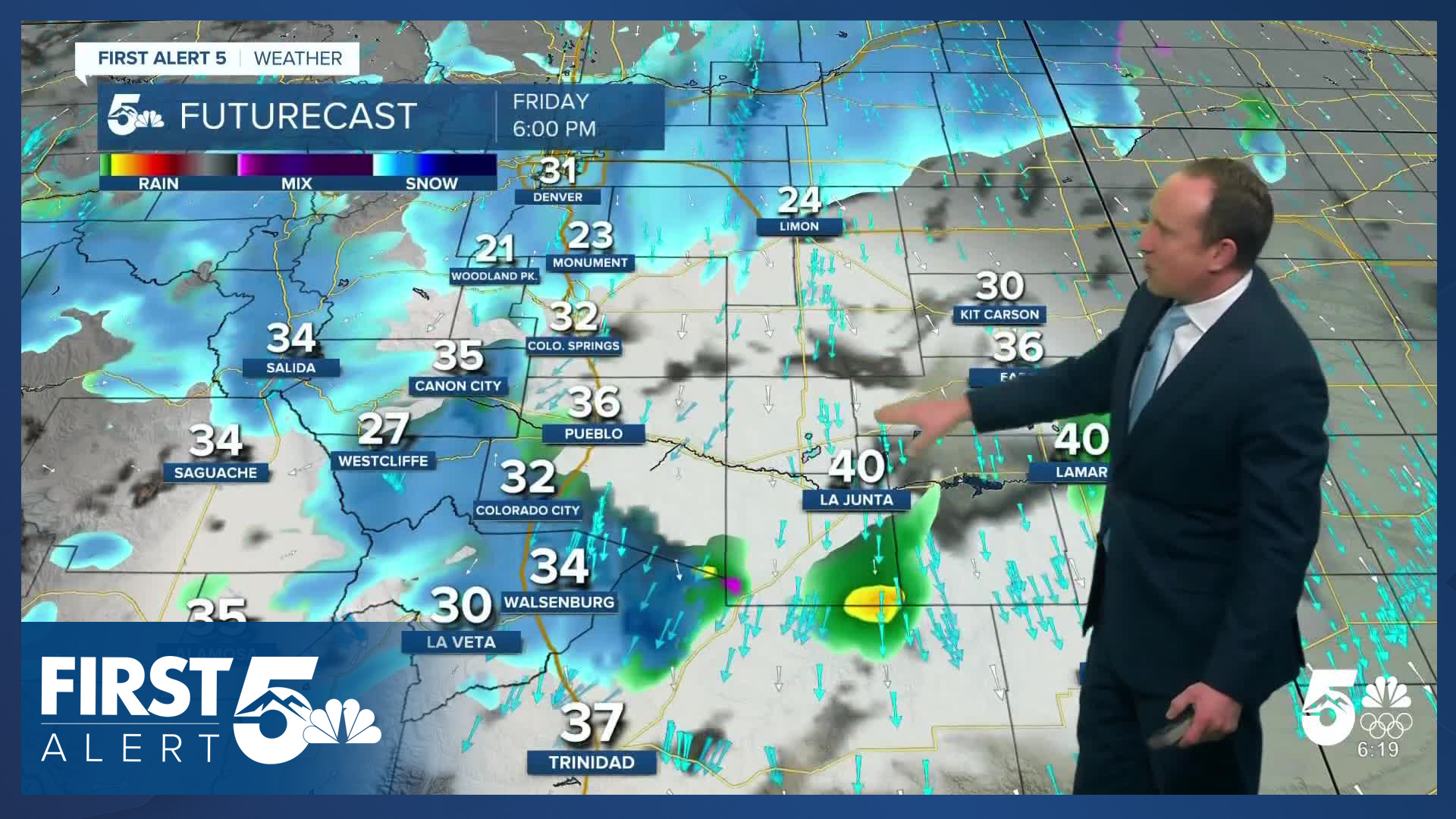
2:00 PM Friday
The City of Colorado Springs says it has updated its plow crew response and has now entered full call out. Crews are primarily targeting the west and south sides of Colorado Springs, while partial crews are working on the north and east sides of the city.
UPDATE: Full crews are out, with 50+ plows working on the west and south sides of the city. The north and east sides currently have partial crews.
— City of Colorado Springs (@CityofCOS) March 6, 2026
This evening, crews will focus on clearing primary and secondary roads. https://t.co/mrXhe59lnG
1:00 PM Friday
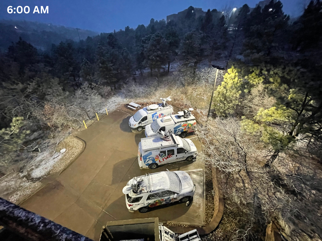
Good snow accumulation is taking place across the market area. Here at our Rockrimmon studio, we are seeing a good 2-3 inches of snowfall over the last few hours.

12:00 PM Friday
The Colorado Springs Police Department has entered cold reporting status. Cold reporting is as follows:
Drivers are reminded if they are involved in a traffic accident with no fatality or injury requiring medical attention, no driver involved is suspected of driving under the influence of alcohol or drugs, all drivers are present with license, registration and insurance information, and no damage to public property such as a street sign or utility pole has occurred, drivers should exchange their information and follow the procedure for completing a counter (cold) report. When damage to any vehicle requires a wrecker, a counter report can still be made providing the previous criteria is met. Drivers can either pick up a traffic accident report form at any of the police department substations or they can go online at coloradosprings.gov/police, click on “Online Reporting” and select “Cold Reporting: Report a Minor Traffic Accident” for instructions. Drivers should also be reminded to take the appropriate steps to avoid being involved in a traffic accident during adverse weather and road conditions. Drivers should check road and travel conditions before heading out and leave more time to get to their destination. Drivers need to travel at a safe speed for the conditions and leave an increased and safe following distance from the vehicle in front of them. Drivers should use streets and roadways less hazardous in winter driving conditions. Drivers also need to remove snow and ice obstructing their vision and have adequate snow tires on their vehicles. Please Drive Safely!
11:30 AM Friday
Snow showers are continuing across much of the Front Range corridor at the moment. The snow level is currently at 5,100 feet with rain south of the El Paso County - Pueblo County line. Rain is also the primary precipitation type along the U.S. 50 corridor. Heavier snow rates are likely to move into southern El Paso County within the next 30 minutes as stronger upper-level energy pivots into the area.
Blowing snow is creating significant visibility reductions over Monument Hill at the moment - use caution if you need to travel, and consider delaying non-essential travel until the snow rates decrease. Roads are snow covered and slippery in Teller County.
9:00 AM Friday
Snow has now filled in across the Pikes Peak Region as the lower atmosphere saturates. Snow is particularly heavy across parts of the lower U.S. 24 corridor between the Springs and Chipita Park with rates approaching 1"/hour. Within the broader shield of snow, heavier bands are rotating northeast and will continue to do so over the next several hours.
Temperatures are marginal — which is typical for spring storm systems. The temperature at the Colorado Springs Airport is 36 degrees. Right at 32 at the Air Force Academy, and below freezing north to the Palmer Divide. When it's snowing heavily, temperatures will locally drop to freezing. This means you'll mainly see road accumulations during snow bands, while it will only accumulate on grass when the snow rate is lighter.
Visibility within bands is dropping to 1-2 miles - and that is independent of temperatures.
Help Us Tell The Story
What's the weather like in your area? Share your photos and videos with us, and we will share them online and on-air!
Road Closures
No major reports of road closures at this time, 9:00 a.m.
Today's Forecast:
Our well-advertised winter storm is here - as a cold front blasts south this morning through Southern Colorado. High temperatures in most areas have already occurred today. That occurred around midnight in Colorado Springs.
Snow will move in through the morning hours, with a favorable lift and instability in the atmosphere today. In fact, we have three mechanisms to lift the air this morning (which is how we get precipitation). First, the upslope northeast flow is driven by the cold front. The second is a bit of atmospheric instability driven by unusually high mid-atmospheric moisture (around the height of Pikes Peak). Finally, we have lift from an area of an incoming low-pressure system.
With this type of setup, we typically see snow banding, which we're already observing early today. We also see a unique type of storm motion - with showers individually moving to the northeast...even though the low-level airflow and cloud direction appears to move southwest.
Temperatures will drop this morning with today's unofficial high at the Colorado Springs airport of 43 degrees, which was the temperature at around midnight.
Scroll down for specific storm timings!
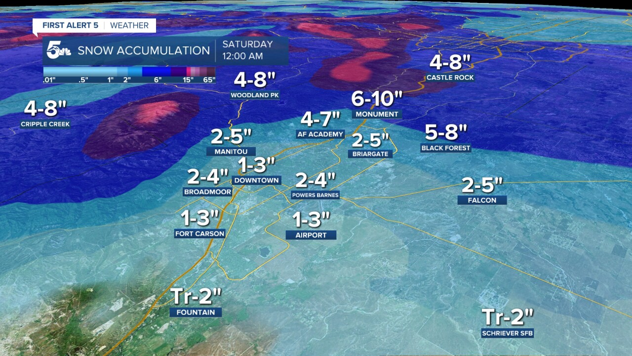
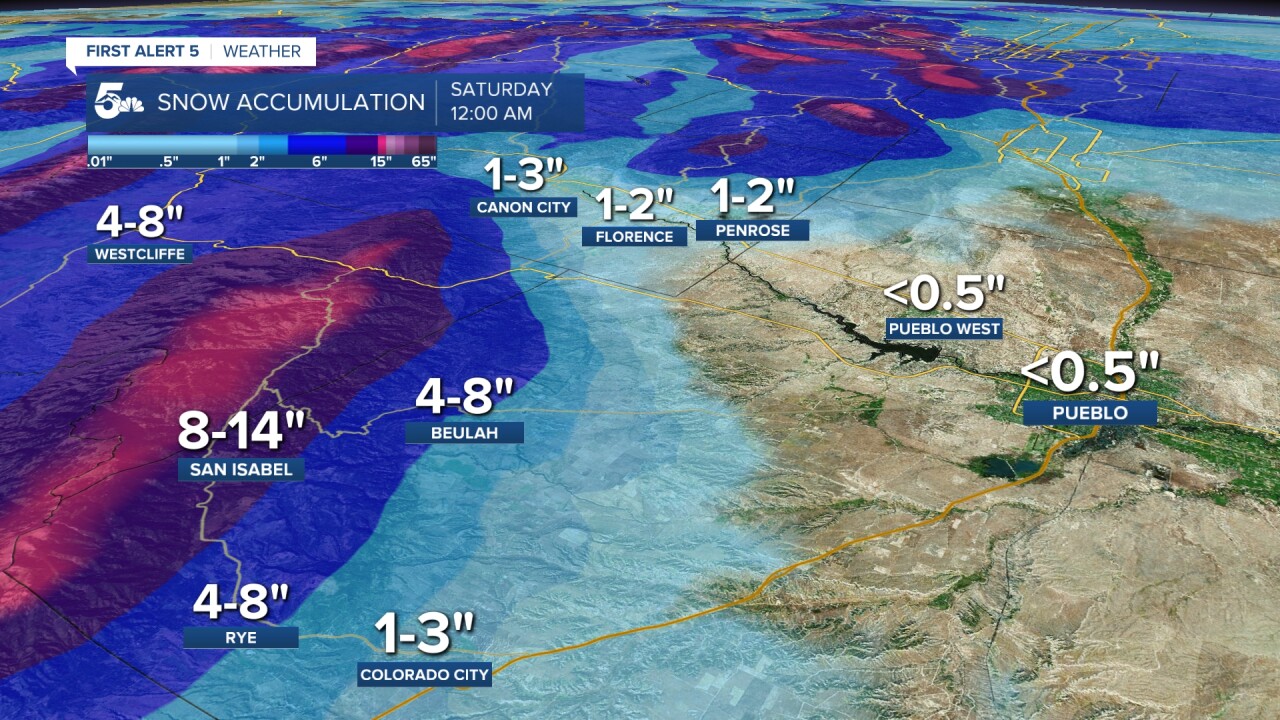
Snowfall Accumulations:
Snowfall will be highest in the mountain zones over the Palmer Divide and Teller County


Timing:
Snow will move in through the morning hours.
Expect patchy snow showers to develop between early this morning mainly in and north of Colorado Springs into the Palmer Divide and Teller County. These early showers will be quick and spotty, and produce little notable accumulation. They'll partly evaporate into drier low-level air which will help with snow later in the morning.
During the morning commute, snow will become steadier and will "fill in". This is when you'll experience more impacts, particularly if you're driving over the Palmer Divide or through Ute Pass. Snow will be moderate to heavy at times in these quick moving bands within a larger shield of lighter snow. Within the bands, expect low visibility with blowing snow.
The heaviest and steadiest snow is likely between 7 AM - 2 PM in the Pikes Peak Region and over Monument Hill and Teller County. As a surface low pivots east, our wind direction will eventually shift from northeasterly to north. This will begin to lighten the snow rate because this is a dry wind direction. You'll continue to see lighter continuous snow through around 2:00/3:00 PM as the surface low remains close by. At the same time, snow will pick up this afternoon across the Wets and Sangres, especially on the eastern slopes.
Snow then becomes patchier and more focused on terrain features through the rest of the afternoon in the Pikes Peak Region - Woodland Park and the Palmer Divide keep snow showers later than Colorado Springs itself. It comes to an end this evening.
Track this storm through the morning, including snow totals and updated forecasts, on the First Alert 5 Weather stream, which can be viewed on the KOAA News5 app for your Roku, FireTV, AppleTV or AndroidTV.
Resources:
- Get your latest First Alert 5 Weather Forecast
- Find the current school closing and delay list
- Keep track of flight delays at Denver International Airport or the Colorado Springs Airport
- Watch KOAA News5 LIVE newscasts and updated content throughout the day in your browser, the News5 App, or your favorite streaming device.
- Download the free News5 App for your iOS or Android device to get the latest headlines and news across Colorado.
- Download the free First Alert 5 Weather App for your iOS or Android device to get the latest headlines and news across Colorado.
- You can find us on social media with KOAA on YouTube, Facebook, Instagram, Twitter, and BlueSky.