


Tonight's Forecast:
Periods of snow are expected to continue tonight across parts of Southern Colorado. The heaviest snowfall will occur over the mountains, but falling snow across the I-25 corridor, middle and upper Arkansas River Valley and high mountain valleys could impact drivers. Additional accumulations along the I-25 corridor are expected to range from a trace to 3" of snow.
The other story will continue to be the COLD! Overnight lows and wind chill temperatures will be frigid. Widespread negative lows and single digits can be expected throughout the region. Dangerous wind chill values down to -25 degrees will also be possible through tomorrow morning.

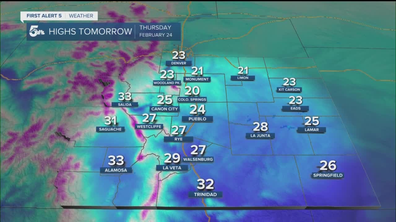
Colorado Springs forecast: Low: -4; High: 20; Other than a few light flurries early Thursday morning, we're expecting a transition during the day to sunshine and blue skies. Even though the snow is expected to come to an end, the cold is not ready to depart. Sub-freezing temperatures will continue during the day across the Pikes Peak Region.
Pueblo forecast: Low: -4; High: 24; Mostly cloudy skies and dangerous cold will give way to a mostly sunny afternoon as temperatures begin to moderate across the area. Afternoon highs are expected to top out in the middle 20s.
Canon City forecast: Low: -3; High: 25; The Arctic attack will continue with a cold and snowy night expected to give way to a mostly sunny and slightly warmer afternoon. Although warmer, temperatures on Thursday will remain below the freezing mark.
Woodland Park forecast: Low: -3; High: 23; Cold and snowy conditions through tomorrow morning from another round of wintry weather before dry skies return to our forecast by Thursday afternoon. Although the sunshine returns, brace for more cold!
Tri-Lakes forecast: Low: -0s/0s; High: 20s; Dangerous overnight wind chills and snow will gradually give way to a less unsettled and brighter day on Thursday as dry skies move back into the region.
Plains forecast: Low: -0s/0s; High: 20s; The potential for more dangerous cold has prompted a new Wind Chill Advisory for the Plains. Wind chill readings through Thursday morning could drop as low as -20 degrees. Skies Thursday will turn partly sunny by the afternoon as the storm finally clears out.
Walsenburg and Trinidad forecast: Low: -0s/0s; High: 20s/30s; Overnight snow showers could be quite heavy, with an additional 2-4" of snow for Walsenburg, and 1-2" for Trinidad. Mostly sunny skies will return on Thursday, but highs will remain below freezing.
Mountains forecast: Low: -0s/0s; High: 10s/20s; Winter Storm Warnings will remain in effect until 5 am Thursday for the mountains. Another 2-6" of snow is expected to fall across the Wet Mountains, with as much as 4-9" in the Sangres. A few lingering snow showers will be possible on Thursday, with only light accumulations expected during the day. Otherwise, it will remain windy and cold across the high country, so make sure to stay bundled up and warm.
Extended outlook forecast:
We're looking at a much quieter extended forecast across Southern Colorado, along with ample time to thaw out. Friday will still be chilly as highs will only warm into the 30s and 40s. For some however, we should finally warm above the freezing mark.
A much more pronounced warming trend will take place this weekend, with highs by Sunday topping out in the 50s.
____
Watch KOAA News5 on your time, anytime with our free streaming app available for your Roku, FireTV, AppleTV and Android TV. Just search KOAA News5, download and start watching.
