


Tonight's Forecast:
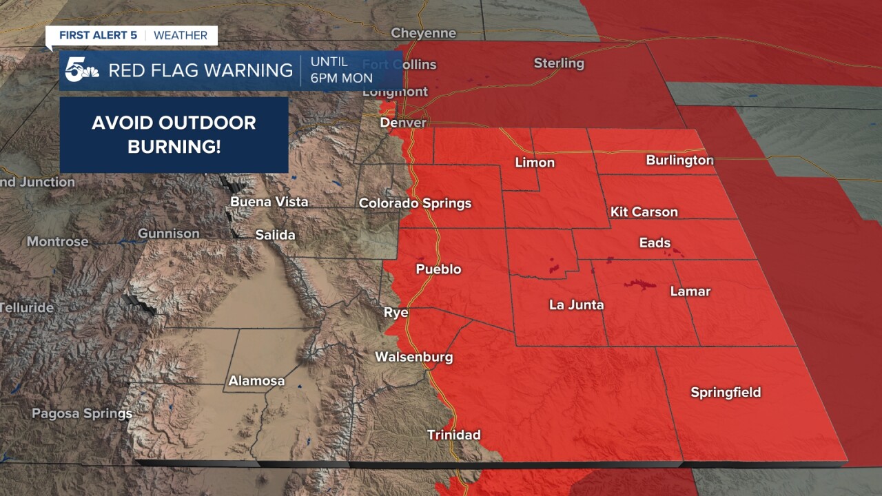
Fire Weather Warnings continue across southern Colorado through 8PM with humidity slowly increasing. Avoid all outdoor burning this evening. Winds will relax for a couple hours this evening before becoming gusty once again late tonight. The strongest winds will be west of I-25, with gusts east of I-25 to 45 mph, and west of I-25 to 60 mph.
Colorado Springs forecast: Low: 40; High: 68;
Partly cloudy with slightly higher relative humidity, remaining breezy to windy. West winds at 10-15 mph increasing to 15-25 mph after 10PM, with gusts to 45 mph after midnight east of I-25 and to 60 mph after midnight west of I-25. Very strong winds continue tomorrow which may result in blowing dust. For more on tomorrow, see the extended forecast below.
Pueblo forecast: Low: 40; High: 74;
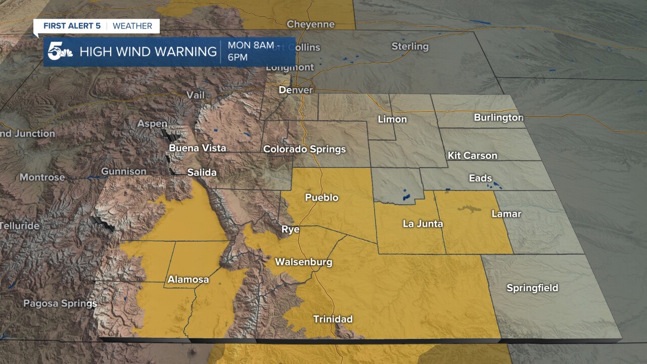
HIGH WIND WARNING from 8AM - 6PM Monday
Partly cloudy with west winds at 20-35 mph, gusting to 45 mph. Blowing dust is possible overnight, continuing tomorrow, with very high fire danger.
Canon City forecast: Low: 42; High: 67;
Partly cloudy with northwest winds at 15-25 mph, decreasing to 10-20 mph after 2AM. Gusts before 2AM may be up to 40 mph. Very windy on Monday!
Woodland Park forecast: Low: 33; High: 52;
Mostly clear with west winds at 15-30 mph gusting to 55 mph. The winds get stronger tomorrow.
Tri-Lakes forecast: Low: Upper 30s; High: 60s;
Partly cloudy with west winds at 15-35 mph gusting to 55 mph. Areas of blowing dust tonight and tomorrow.
Plains forecast: Low: 30s; High: 70s;
HIGH WIND WARNING for the southern plains from 8AM - 6PM Monday
HIGH WIND WATCH in effect for the southern plains from 5AM - 5PM Tuesday
Partly cloudy with varied winds, strongest in the southern tier. Westerly for everyone, generally at 10-25 mph, gusting to 50 mph, with the strongest winds closer to the mountains.
Walsenburg and Trinidad forecast: Low: 45; High: 60/64;
HIGH WIND WARNING from 8AM - 6PM Monday
HIGH WIND WATCH from 5AM - 5PM Tuesday
Mostly clear with west winds at 10-30 mph gusting to 50 mph with areas of blowing dust. Although fire danger will be lower tonight, it remains elevated - avoid outdoor burning.
Mountains forecast: Low: 30s/40s; High: 50s;
HIGH WIND WATCH from 5AM - 5PM Tuesday
Mostly clear with west winds at 10-30 mph gusting to 55 mph. Areas of blowing dust in some zones which will reduce visibility. Very high fire danger - do not start a campfire or do any other outdoor burning!
Extended outlook forecast:
Dangerous weather conditions will impact southern Colorado on Monday. A potent combination of strong winds, and very low humidity, will result in very high fire danger throughout the day - higher than on Sunday. Fire Weather Warnings are in place for ALL of Colorado east of the Front Range mountains on Monday including all of Southern Colorado.
South of Highway 50, High Wind Warnings are in effect tomorrow. Winds will be sustained at 30-40 mph, gusting above 60 mph. This will result in several issues beyond the Fire Threat:
- Strong winds may blow outdoor furniture and trash cans off property and/or into your home. Move these inside or otherwise shelter them from the wind.
- Blowing dust in the southern plains will reduce visibility at times.
- Strong cross winds on N-S roads will make travel difficult.
- Small tree branches may break, particularly on trees that have vegetation right now.
North of highway 50, winds will be a bit weaker, but not by much. Expect 25-40 mph winds, with gusts to 55 mph. Across the entire region, humidity will drop to the single digits. Avoid all outdoor burning tomorrow, and be extra vigilant for smoke. If you do see smoke, call 9-1-1.
Active and concerning weather continues Tuesday. High winds will be ongoing in the morning. High Wind Watches are in place for the southern tier, where winds may be the strongest of the entire Sunday - Tuesday period, with 35-45 mph sustained winds gusting to 70 mph. This will create elevated and potentially high fire risk again for the first part of Tuesday - however humidity may be higher ahead of your next snow maker. In the afternoon, a very strong cold front will blast through the area, leading to strong northerly winds. This will not be a hard cold front to notice...you'll feel the air cool very quickly and the change in wind direction after it passes by. As temperatures cool, skies become cloudy and you'll see rain showers during the afternoon transitioning to snow. This will be a quick snowmaker for us - with an inch or two of accumulation possible in our higher terrain and cooler areas. It'll have trouble sticking to the roads given the recent warmth, however very cold lows in the teens on Tuesday night will result in a flash freezing concern that we'll need to watch. Winds will drop back following this cold front, and temperatures Wednesday morning will be a case of weather whiplash - Tuesday's highs will be in the low 50s, and you'll wake up to wind chills near the 10 degree mark.
Wednesday won't be great for hiking as high terrain will be snow covered - with lower terrain likely muddy. The good news is that quieter weather arrives Wednesday - with cool highs in the 40s, before temperatures rebound with a nice, sunny, and relatively calm pattern by the end of the week as we climb back to the 60s with sunshine.
____
Curious about the First Alert 5 Weather Storm Impact Scale? Check out our cheatsheet explainer.
Watch KOAA News5 on your time, anytime with our free streaming app available for your Roku, FireTV, AppleTV and Android TV. Just search KOAA News5, download and start watching.
