


Today’s Forecast:
A quiet morning will give way to some major changes later today and tonight as the biggest storm of the season rolls into Southern Colorado. Snow showers will begin to build in the mountains and foothills by around the lunch hour, with rain and snow then reaching the I-25 corridor by mid to late afternoon. This storm will be packing a punch, and with plenty of instability in place, thunderstorms will be possible this afternoon on the I-25 corridor and Plains. In the mountains, snow squalls, or brief periods of intense snow and wind will be possible.
Snow levels will start out around 7,000 feet today, but will lower to down to 5,000 to 6,000 feet by Thursday morning. Snow will pick up in intensity and coverage late tonight and into the overnight hours, with as much as 6-12" of accumulation possible by Thursday morning on the Palmer Divide, Teller County and the mountains. Impacts to travel can be expected by Thursday morning in some areas.
This graphic below should help with planning, by giving you an idea of when conditions could start to get bad on the roads where you live.

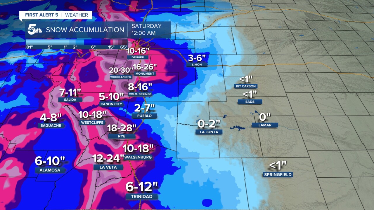
Colorado Springs forecast: High: 50; Low: 30. What begins as a quiet day in Colorado Springs will end on a much different note as rain and snow moves into Southern Colorado. Rain and thunderstorms will be possible this afternoon before turning to snow tonight. Heavy snow will be possible above 6,000 feet during the overnight hours.
Pueblo forecast: High: 60; Low: 32. We'll find ourselves in the warm sector of the storm most of the day, with precipitation this afternoon falling as rain. With quite a bit of instability this afternoon, thunderstorms with lightning and small hail will be possible. Some snow will mix in with rain overnight tonight, with little impacts to roads through Thursday morning.
Canon City forecast: High: 55; Low: 32. Mild and dry this morning, but turning stormy this afternoon as the start of our days long storm arrives. A changeover to snow is likely around midnight, with snow likely to stick overnight and into Thursday morning.
Woodland Park forecast: High: 41; Low: 21. Snow will begin to develop by the afternoon, with deteriorating conditions by this evening. Snow will pile up quickly into the overnight hours, with snow rates around 1-2" per hour. Snow totals by Thursday morning could approach 12" in some areas, with much more on the way tomorrow.
Tri-Lakes forecast: High: 40s; Low: 20s. Today is the day to get ready before conditions start to go downhill by as early as this afternoon. Heavy snow will develop later tonight, with 6-12" of accumulation possible by tomorrow morning.
Plains forecast: High: 60s; Low: 30s. Dry skies and mild highs Wednesday will give way to rain and thunderstorms by late this afternoon and evening. Snow levels will be quite high through this evening, staying above 6,000 feet before falling to near 5,000 feet by Thursday morning.
Walsenburg and Trinidad forecast: High: 50s; Low: 20s/30s. Now is the time to get stuff done before a major winter storm rolls into our area this evening. A few showers and thunderstorms will be possible by late this afternoon before we see a changeover to snow tonight and Thursday morning.
Mountains forecast: High: 30s; Low: 10s/20s. Snow will be developing during the day before becoming heavy this evening and overnight tonight. Snow will continue on Thursday before wrapping up on Friday, with travel not recommended in the high country from late tonight into the day on Thursday.
Extended outlook forecast:
The worst of the storm for the Pikes Peak Region will be on Thursday. On top of snow, which will be persistent, heavy and wet, 30-35 mph wind gusts and cold temperatures will make for a nasty day to be outside or travel. Highs on Thursday and Friday will only warm into the lower to middle 30s in Colorado Springs. Snow levels around 5,000 to 6,000 feet will mean much lower snow totals for areas that fall in this elevation range and below. Below 4,500 feet, I think that we'll mostly be dealing with rain.
Snow showers will continue at times early Friday before drier air shuts down the snow machine Friday evening. Snow totals in Colorado Springs will be the highest of the year, ranging from 8-16", with the highest totals city-wide occurring above 6,500 feet. Monument is expecting as much as 16-26" of snow. Woodland Park I think will see 20-30" snow totals. Travel is not advised on Thursday in these areas. Major delays and/or road closures should be expected during the height of the storm.
____
Curious about the First Alert 5 Weather Storm Impact Scale? Check out our cheatsheet explainer.
Watch KOAA News5 on your time, anytime with our free streaming app available for your Roku, FireTV, AppleTV and Android TV. Just search KOAA News5, download and start watching.
