


Tonight's Forecast:
Another weak front will bring the potential for a few mountain snow showers, and rain or snow showers to the Palmer Divide and Teller County later tonight. Otherwise, it's a dry front that will be long gone by Thursday morning.
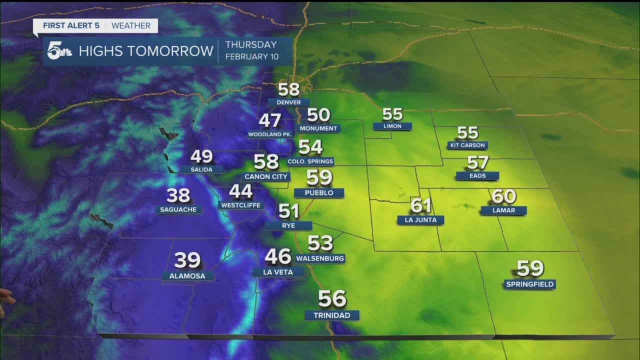
Colorado Springs forecast: Low: 24; High: 54. A mostly sunny and mild Thursday for the Pikes Peak Region. Thanks to light downslope winds, highs should climb well into the 50s.
Pueblo forecast: Low: 20; High: 59. Sunshine and way above average highs for our Thursday. Afternoon temperatures could approach the 60 degree mark in some areas.
Canon City forecast: Low: 28; High: 58. A little on the breezy side tomorrow, but it's that downslope flow that will treat us to well above average highs in the middle Arkansas River Valley.
Woodland Park forecast: Low: 17; High: 47. Warm for this time of the year for Teller County. Even with the high elevation, afternoon highs look to top out in the middle to upper 40s.
Tri-Lakes forecast: Low: 10s/20s; High: 40s/50s. After the potential for a few passing overnight snow showers, we'll see a return to bright, breezy and pleasant weather on Thursday.
Plains forecast: Low: 10s/20s; High: 50s/60s. Absolutely nothing to complain about weather wise on Thursday as we'll be treated to a sunny, mild and breezy day across the Plains.
Walsenburg and Trinidad forecast: Low: 10s/20s; High: 50s. A little breezy at times on Thursday, but our mild and sunny forecast should make up for it by providing us with more great weather.
Mountains forecast: Low: 10s; High: 30s/40s. High pressure over the West Coast will continue to deliver more great weather to the mountains of Southern Colorado on Thursday ahead of a potential snow-maker come Friday and Saturday.
Extended outlook forecast:
The wind will crank even harder by Friday afternoon, with the potential for northerly gusts to reach 30-40 mph across parts of Southern Colorado. The potential for a round of light snow will follow from late Friday afternoon into very early Saturday morning. Up to 1" or so of accumulation will be possible along the I-25 corridor, with 1-3" for the Palmer Divide, Teller County and our local mountains.
We expect to dry out and warm up from Sunday into early next week before a potentially bigger snow-maker drops into the region next Wednesday.
____
Watch KOAA News5 on your time, anytime with our free streaming app available for your Roku, FireTV, AppleTV and Android TV. Just search KOAA News5, download and start watching.
