


Tonight's Forecast:
Scattered mountain showers and thunderstorms will continue for the high country through late this evening, with a few of these storms possibly reaching the I-25 corridor. Along the interstate, storms will favor the northern I-25 corridor from Pueblo to Monument versus areas to the south that should stay dry.
Under mostly clear skies, overnight lows should cool down comfortably to the 40s and 50s.
Colorado Springs forecast: Low: 53; High: 87; Drier air courtesy of a building of high pressure that will bring ample sunshine and above average temperatures to our forecast on Tuesday.
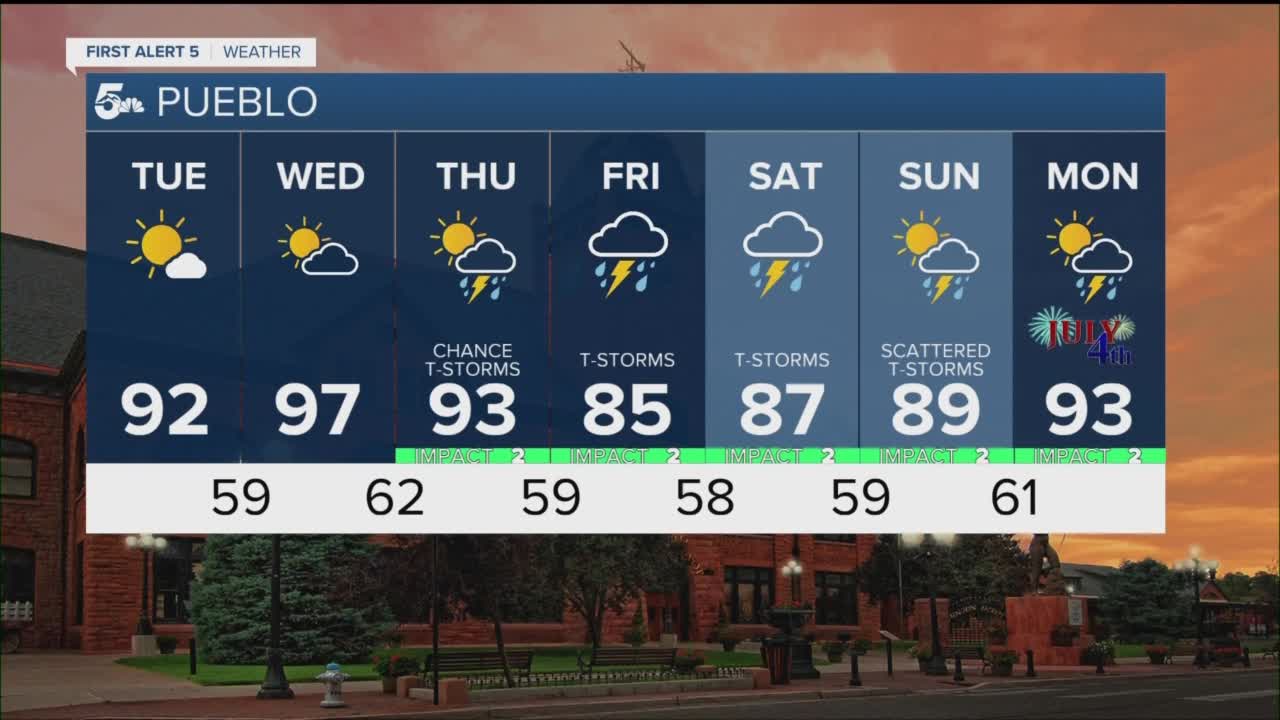
Pueblo forecast: Low: 56; High: 92; After a break from the heat these past few days, lower 90s and sunshine will return to Pueblo on Tuesday, with Wednesday even hotter.
Canon City forecast: Low: 58; High: 88; Heating up on Tuesday under the influence of high pressure. The same high pressure system is likely to dry us out through the middle of the week.
Woodland Park forecast: Low: 46; High: 78; Mostly sunny to partly cloudy and warmer on Tuesday, with a very slight chance of an afternoon shower or thunderstorm.
Tri-Lakes forecast: Low: 40s/50s; High: 80s; A nice warm-up for our Tuesday as highs across the Palmer Divide look to top out in the 80s.
Plains forecast: Low: 50s; High: 80s/90s; After a pleasant morning, we'll see a hot and sunny afternoon across the Plains, with highs topping out in the upper 80s and lower 90s.
Walsenburg and Trinidad forecast: Low: 40s/50s; High: 70s/80s; Warming highs on Tuesday, with just a very small chance of an isolated shower or thunderstorm in Huerfano County.
Mountains forecast: Low: 40s; High: 60s/70s; Less moisture to work with on Tuesday, but still enough that I think we'll generate a few isolated showers and thunderstorms over the mountains. With slow upper level winds, any storms that form could pose a risk of flash flooding across recent burn scars.
Extended outlook forecast:
Tuesday's warm-up will peak on Wednesday, with 90s on tap for the Plains, and another dry day for areas along and east of the interstate. If we do see any rain on Wednesday outside of the mountains, it would be along and near the Palmer Divide. A cold front Thursday will push high pressure east and allow for the monsoon moisture to push back into Colorado. Look for better storm chances Thursday, and even stormier days in our forecast from Friday to Saturday.
____
Curious about the First Alert 5 Weather Storm Impact Scale? Check out our cheatsheet explainer.
Watch KOAA News5 on your time, anytime with our free streaming app available for your Roku, FireTV, AppleTV and Android TV. Just search KOAA News5, download and start watching.
