

Today’s Forecast:
After record heat on Sunday and cooler than average highs on Monday, temperatures will swing back up to above average territory on Tuesday. Afternoon highs on the Plains will mainly warm into the 70s, with a few spots possibly passing the 80 degree mark. Skies will remain dry on Tuesday as November trends looking forward feature very little chances for rain or snow over the next 5-7 days.
It will be moderately breezy today as well, with gusts to around 35 mph near the mountains and for areas south of Highway 50. While Red Flag Warnings are not anticipated today, spotty fire danger will be possible in windy areas.
Colorado Springs forecast: High: 73; Low: 39. We'll be warming back up on Tuesday, with our high this afternoon more than 15 degrees above average. Current record: 78° (1924).
Pueblo forecast: High: 78; Low: 34. We've seen some of the coldest temperatures regionally this morning. By the afternoon, downslope breezes coming off of the Wet Mountains will warm us into the upper 70s, which is around 15 degrees above average. Current record: 78° (1924).
Canon City forecast: High: 75; Low: 40. After Monday's cool down, highs on Tuesday will be uncharacteristically warm for this time of the year. We will be topping out today in the middle 70s.
Woodland Park forecast: High: 64; Low: 34. Well above average highs will continue across Teller County on Tuesday, with moderate wind gusts this afternoon up around 25 mph. The wind will be blowing from west to east on Tuesday.
Tri-Lakes forecast: High: 60s/70s; Low: 30s. Late October was pretty dry in northern El Paso County and November starts out with more of the same. No sign of snow on Tuesday as highs top out in the upper 60s and lower 70s.
Plains forecast: High: 70s; Low: 30s/40s. Breezy to gusty and very warm on Tuesday. Highs in some areas will be more than 20 degrees warmer than what we saw on Monday.
Walsenburg and Trinidad forecast: High: 70s; Low: 30s/40s. It will be gusty and warm along the eastern slopes this afternoon. Peak gusts in Walsenburg this morning have already topped 30 mph, and it will likely remain windy here most of the day.
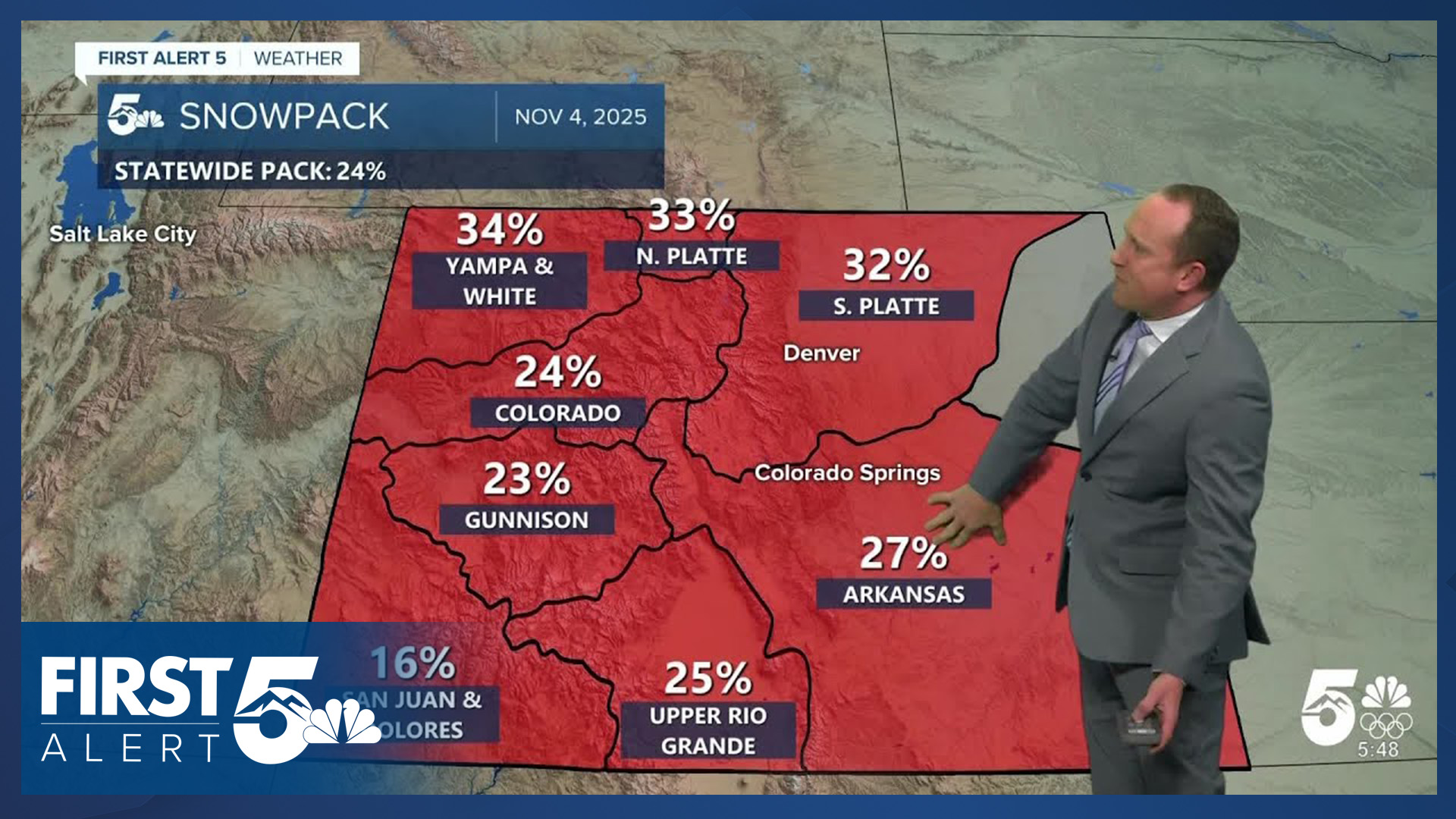
Mountains forecast: High: 50s/60s; Low: 30s. Snowpack in our state sits at just 24% of average and today's forecast will be dry, with windy and mild conditions on tap for the southeastern mountains.
Extended outlook forecast:
An early morning cold front on Wednesday will shave off around 10 degrees to our highs. In Colorado Springs, we'll trade out today's 70s for highs in the lower 60s. Stronger downslope wind gusts to 30 mph on Thursday will allow for highs to return to the 70s on the Plains. These stronger gusts could lead to Red Flag Warnings on Thursday for parts of the state.
Another cold front Friday morning will lead to a more pronounced cooling trend. Highs Friday will warm into the lower 60s in Colorado Springs. Highs Saturday will warm into the upper 50s. By Sunday, our high will only warm into the upper 40s. As for the first snow of the season, I'm not seeing any threats of wintry weather over the next 7-10 days.
____
Curious about the First Alert 5 Weather Storm Impact Scale? Check out our cheatsheet explainer.
Watch KOAA News5 on your time, anytime with our free streaming app available for your Roku, FireTV, AppleTV and Android TV. Just search KOAA News5, download and start watching.
