

Today’s Forecast:
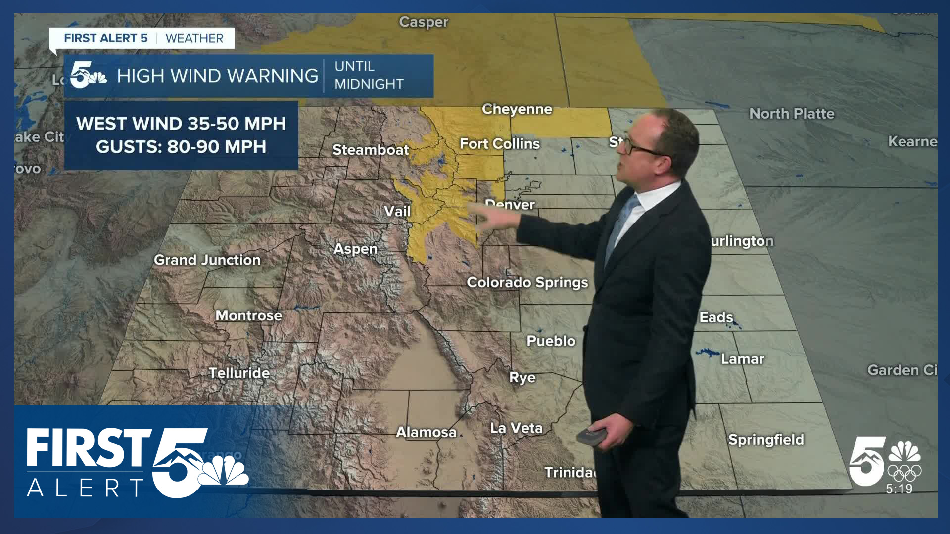
It will be a gusty day in Southern Colorado, and warmer than Monday. A strong northwesterly jet stream is pulling in plenty of energy for a downslope wind event. Damaging wind gusts are in the cards for the northern and central mountains where High Wind Warnings are in effect until midnight.
In the Pikes Peak Region, wind gusts of 25-35 mph will be possible this afternoon. The Ute Pass, Palmer Divide, Tri-Lakes area, Manitou Springs, Broadmoor, and areas just east of the Rampart Mountains tend to be favored in northwest downslope flow setups for the most consistent gusts. Otherwise, expect skies to be partly cloudy as the jet pulls plentiful moisture with clouds increasing through the day. Highs will be in the 50s and 60s today on the Plains.
Colorado Springs forecast: High: 58; Low: 31. Warm and gusty downslope flow will push highs into the upper 50s today in Colorado Springs. That's around 15 degrees above our average high for this time of the year. Today's gusts will be around 25-35 mph, with stronger gusts closer to the mountains.
Pueblo forecast: High: 63; Low: 29. Tuesday's forecast will be warm and windy, with peak gusts today up around 30-35 mph. The wind will gradually weaken this afternoon, with lighter westerly winds this evening ahead of a cold front that looks to reach Pueblo County around midnight.
Canon City forecast: High: 60; Low: 35. While Tuesday will be dry in eastern Fremont County, it will be windy, with gusts today up around 35 mph.
Woodland Park forecast: High: 48; Low: 28. Some of the strongest gusts today in the Pikes Peak Region will be in Teller County, with peak wind gusts this afternoon up around 40 mph.
Tri-Lakes forecast: High: 50s; Low: 20s/30s. Tuesday's forecast will be warmer and gusty in northern El Paso County, with peak gusts this afternoon up around 35 mph.
Plains forecast: High: 60s; Low: 20s/30s. Highs on the Plains will be unseasonably warm for this time of the year, with some areas approaching the 70 degree mark this afternoon.
Walsenburg and Trinidad forecast: High: 50s/60s; Low: 30s. Unseasonably warm on Tuesday, with the warm-up driven by wind gusts in the 35-45 mph range. As usual, the strongest gusts will hit Huerfano County more so than Las Animas County.
Mountains forecast: High: 30s/40s; Low: 10s/20s. High Wind Warnings have been issued for the northern and central mountains on Tuesday, right along the Front Range corridor. Gusts in the higher elevations are expected to range between 70-90, with gusts to 60 mph around Boulder and Loveland. Our local mountains won't see quite the same level of wind as our northern neighbors, with gusts to 50 mph in the Sangres and Wets.
Extended outlook forecast:
A backdoor cold front will arrive late this evening. While it will cool temperatures heading into Wednesday, downslope winds will continue. Lows will be in the 20s and 30s, which is above average since many areas are typically in the 10s this time of the year.
There is the potential for patchy fog on Wednesday morning as temperatures across the region cool to the dew point. Otherwise, northerly morning winds will swing southerly to southeasterly during the afternoon. It will be cooler tomorrow, with highs in the 40s and 50s, which is still a bit above average. The average high Wednesday in Colorado Springs is 45 degrees. Skies will again be partly cloudy.
Temperatures will see-saw up and down through the rest of the week. In the upper levels of the atmosphere, winds stay northwesterly through the rest of the week, but the core of the jet stream will shift north, Thursday will be the warmest day of the week with highs in the 60s on the Plains, driven largely by more downslope breezes, though they don't look that strong.
Another relatively weak backdoor cold front arrives early Friday - dropping temperatures back down to the 50s. Upper level high pressure will nudge in this weekend, which will result in relatively quiet weather conditions through Sunday.
____
Curious about the First Alert 5 Weather Storm Impact Scale? Check out our cheatsheet explainer.
Watch KOAA News5 on your time, anytime with our free streaming app available for your Roku, FireTV, AppleTV and Android TV. Just search KOAA News5, download and start watching.
