


Today’s Forecast:
With only six more days until the Autumnal Equinox and my favorite season fall, our weather today will bring some summer-like vibes to Southern Colorado. Temperatures will warm into the 60s and 70s in the mountain valleys and higher elevations, with 70s, 80s and lower 90s on the Plains.
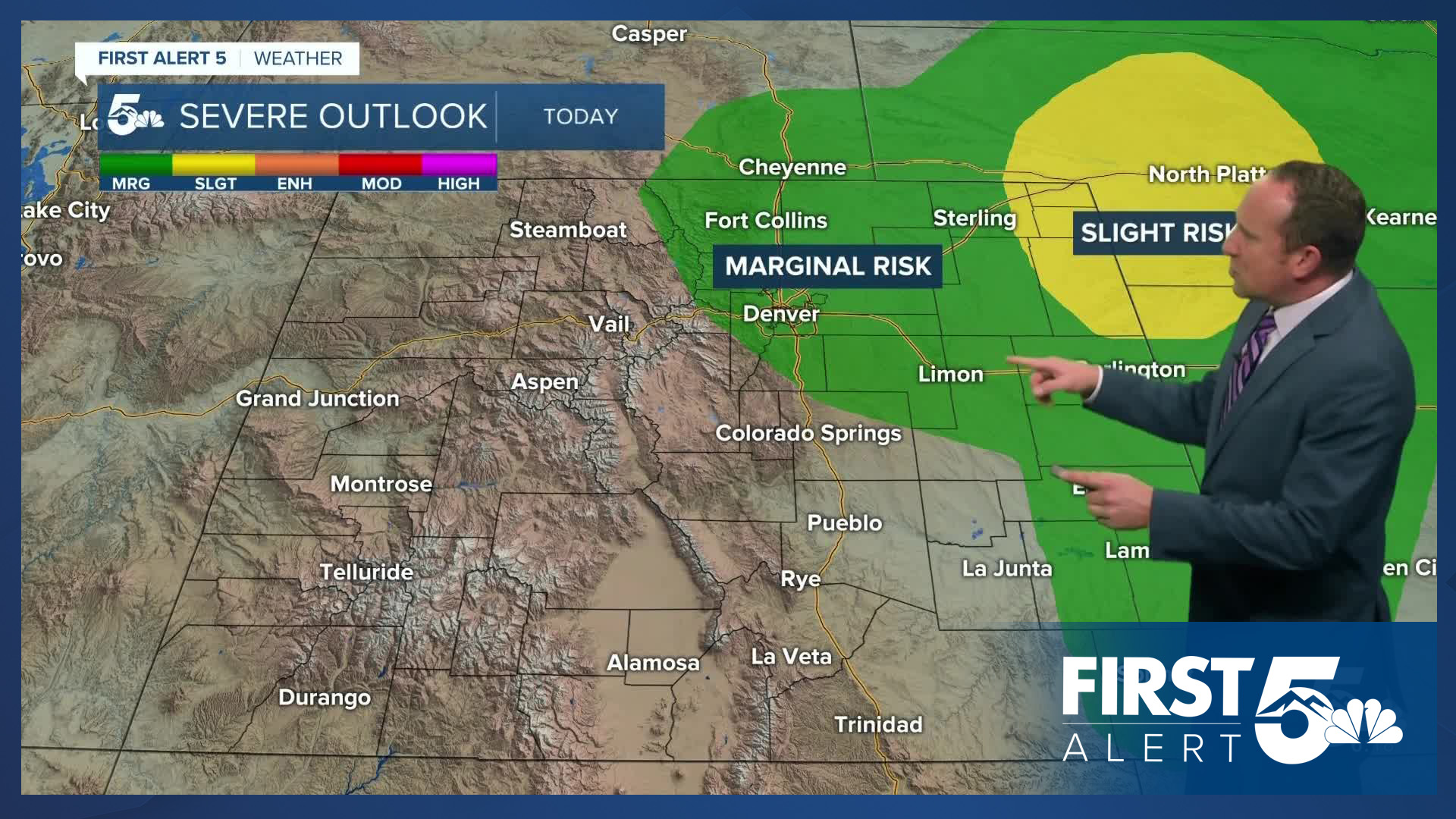
Incoming upper level energy combined with a surface cold front will bring increasing chances for rain to our forecast this afternoon and evening. Storms that initiate over the mountains will push into the I-25 corridor and Plains towards the mid to late afternoon. Due to growing instability and wind shear, storms this afternoon will have the potential to be pretty strong, with low end severe threats on the Palmer Divide and eastern Plains. Risks of severe weather today will include strong outflow wind gusts, hail, and heavy rainfall. Be weather aware!
Colorado Springs forecast: High: 78; Low: 49. Before a cold front arrives later today, temperatures will warm back into the upper 70s. As mentioned above, today is expected to be stormier than the past few days, with some severe weather possible.
Pueblo forecast: High: 86; Low: 51. Very warm temperatures will continue on Tuesday, but with increasing moisture this afternoon across the state, scattered thunderstorms will be possible in our areas.
Canon City forecast: High: 83; Low: 51. Late summer warmth will be served with a course of late summer thunderstorms as some energy moves across the state this afternoon. Keep an eye on the sky this afternoon for any severe weather threats.
Woodland Park forecast: High: 68; Low: 40. Highs today will cool by a few degrees across Teller County. On top of today's slight dip in temperatures, we're also expecting a pretty good chance this afternoon for thunderstorms, some of which could be on the stronger side.
Tri-Lakes forecast: High: 70s; Low: 40s. Skies will turn mostly cloudy this afternoon as a cold front increases our chances for rain across the Palmer Divide, where some storms today will need to be watched for the potential for severe wind gusts and hail.
Plains forecast: High: 80s/90s; Low: 40s/50s. Storms will develop early this afternoon to our east and as they reach a more unstable environment on the Plains, severe threats will be elevated. Today's storms will be capable of 1" hail and 60 mph wind gusts.
Walsenburg and Trinidad forecast: High: 70s/80s; Low: 40s/50s. A quiet morning will give way to increasing chances for rain and thunderstorms this afternoon. If you hear thunder rumbling in your area, take shelter from outdoor activities until storms pass.
Mountains forecast: High: 50s/60s; Low: 30s. West of the Continental Divide, a few storms have already reached the mountains this morning. Closer to home, the Wet Mountains and Sangres will see thunderstorms increase towards the lunch hour. During heavier downpours, snow levels could lower down to 11,000 feet.
Extended outlook forecast:
Today's cold front will cool highs on Wednesday and Thursday by as much as 10-15 degrees across Southern Colorado. Afternoon highs in Colorado Springs during this time will warm into the upper 60s, with middle to upper 50s in Teller County.
Storms will continue across the state on Wednesday, with drying skies by Thursday. Highs will rebound back into the middle 70s by Friday in Colorado Springs, with some warm lower 80s on tap for the final week of summer.
____
Curious about the First Alert 5 Weather Storm Impact Scale? Check out our cheatsheet explainer.
Watch KOAA News5 on your time, anytime with our free streaming app available for your Roku, FireTV, AppleTV and Android TV. Just search KOAA News5, download and start watching.
