

Today’s Forecast:
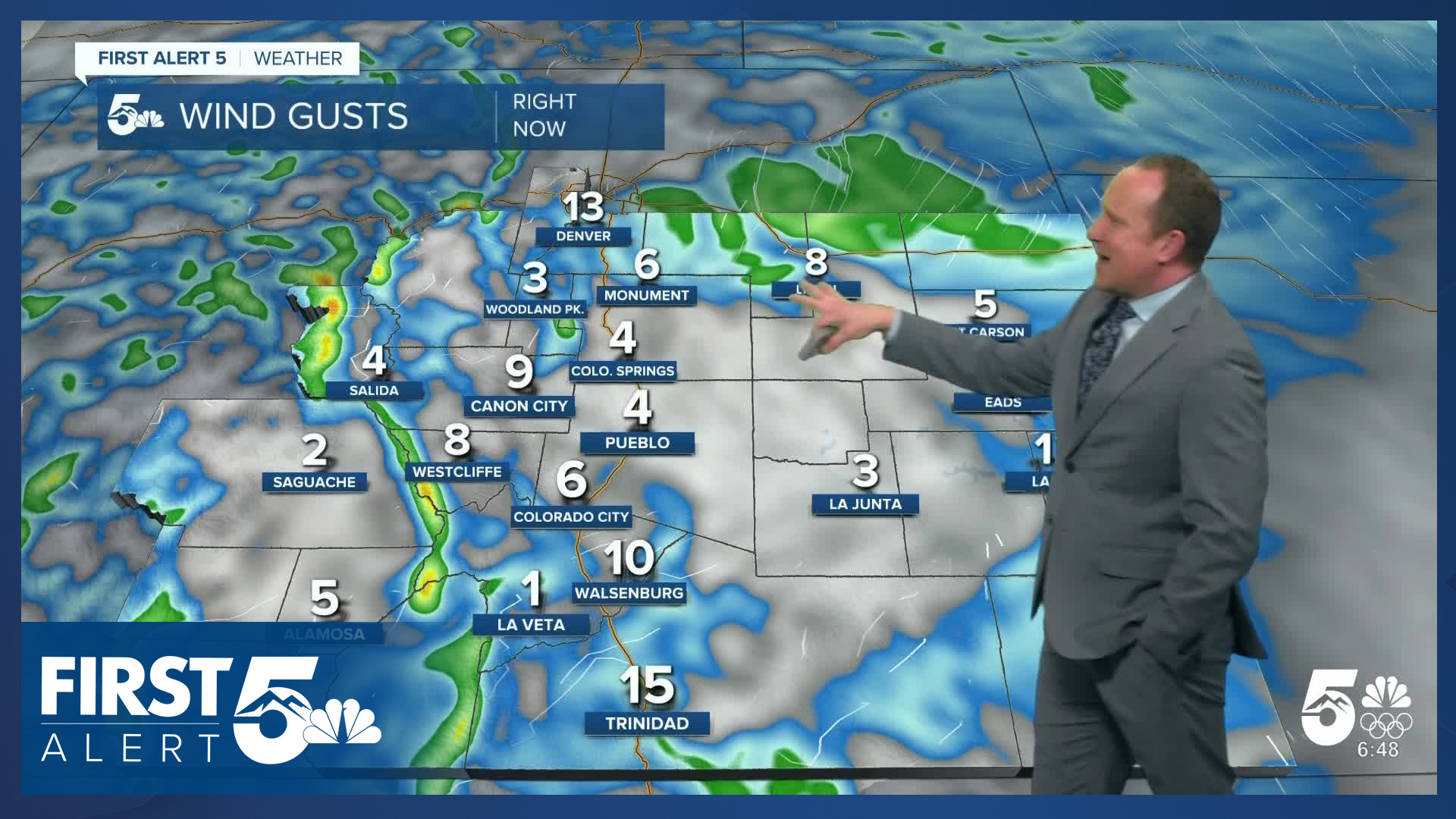
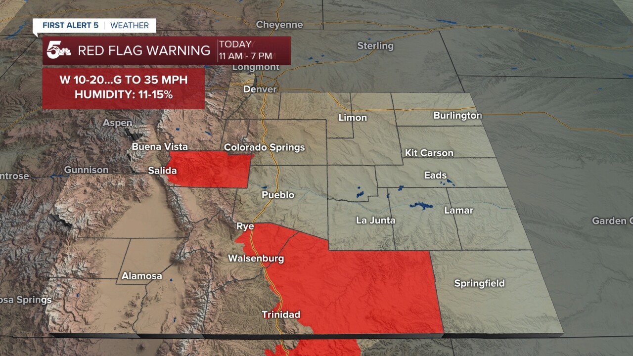
The first week of March will begin on a breezy to gusty and warm note. The wind will be gusting as high as 30-45 mph region-wide today, strongest south of Highway 50 and west of I-25. A Red Flag Warning has been issued today for parts of Huerfano and Las Animas counties, and will remain in place from 11 am to 7 pm. As of 5:15 am, the Red Flag Warning has also been added to Fremont County.
Temperatures today will be around 20 degrees above average for this time of the year, warming into the 60s and 70s. Mountain areas will be mild as well, topping out in the 40s and 50s on Monday.
Colorado Springs forecast: High: 70; Low: 38. After ending February on a warm note, it should come as no surprise that March is set to begin in the same fashion. Driven by 20-30 mph wind gusts, our high of 70 degrees this afternoon is expected to come very close to today's record of 72°F (2022).
Pueblo forecast: High: 75; Low: 36. The wind will be variable and gusty across Pueblo County on Monday, with more of a westerly wind along and west of I-25, and more of a southeasterly wind in eastern parts of the county. Temperatures today will be well above average, topping out in the middle 70s.
Canon City forecast: High: 74; Low: 41. NEW this morning, a Red Flag Warning has been added to Fremont County, in effect from 11 am to 7 pm. Wind gusts to 35 mph, coupled by warm and dry conditions will bring elevated to critical fire danger to some areas today.
Woodland Park forecast: High: 61; Low: 32. The first week of March will start out warm and breezy. Highs today will be around 15-20 degrees above average.
Tri-Lakes forecast: High: 60s; Low: 30s. Warm, dry and breezy on Monday ahead of the first of two storms on Tuesday that will bring us much needed moisture in the week ahead.
Plains forecast: High: 60s/70s; Low: 30s/40s. South and southeasterly winds on the Plains will keep us from high fire danger threats on Monday by keeping enough moisture in the atmosphere to avoid Red Flag Warnings.
Walsenburg and Trinidad forecast: High: 60s/70s; Low: 30s/40s. Warm and windy, with a Red Flag Warning in effect today from 11 am to 7 pm. Gusts in wind prone parts of Huerfano and Las Animas counties could top 45 mph in some areas.
Mountains forecast: High: 40s/50s; Low: 20s/30s. Warm, snowmelt sunshine and wind will make for a gusty day in the mountains. Peak gusts today could top 45 mph in the Wet Mountains and Wet Mountain Valley, with 50-60 mph gusts in the Sangres.
Extended outlook forecast:
Our first cold front of the month arrives on Tuesday, with increasing chances for rain and snow showers towards the afternoon. With highs in the upper 50s in Colorado Springs on Tuesday, this will be a warm storm. Snow levels will start out at or above 8,000 feet, lowering to 7,000 feet by Tuesday evening as the storm winds down.
Wednesday's highs will rebound to near 60 degrees, with a return to the upper 60s on Thursday. Highs in Pueblo on Thursday look to climb into the lower to middle 70s. Additional fire threats will be possible on Thursday, driven by increasing wind ahead of our second storm of the week. That storm will be colder, with lower snow levels and the chance for snow in Colorado Springs on Friday. Right now, it's too soon to talk about snow totals, but it seems reasonable for a few inches of snow in Colorado Springs.
____
Curious about the First Alert 5 Weather Storm Impact Scale? Check out our cheatsheet explainer.
Watch KOAA News5 on your time, anytime with our free streaming app available for your Roku, FireTV, AppleTV and Android TV. Just search KOAA News5, download and start watching.
